When Is Drone Photography Worth It for a New Jersey Listing?
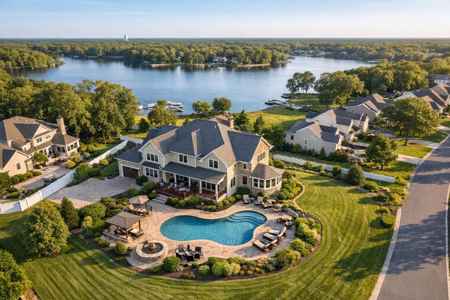
Drone photography in NJ captures a luxurious lakeside neighborhood, showcasing a spacious home with a beautifully landscaped yard and pool, surrounded by lush greenery and calm water.
When Is Drone Photography Worth It for a New Jersey Listing?
Drone photography NJ is often touted as the modern must-have for real estate listings, but the real question isn’t whether it looks impressive or new—the question is: does it show buyers something meaningful that standard photos can’t?
For property professionals across New Jersey and the NYC metro, there’s a simple truth we see again and again: not every listing needs aerial media, but for some, the added perspective is a genuine asset. If you’re evaluating whether real estate drone photography NJ should be part of your next listing, a few practical principles will lead you to the right decision.
Start With the Story: What Does an Aerial View Actually Add?
Every agent or seller knows there are a handful of features that truly sell a property. Sometimes it’s the elegant facade or the sunlit rooms; other times, it’s outdoor amenities, location, or architectural scale. In cities like Hoboken or Jersey City, it might be the rooftop deck or skyline view. Along the Shore, the relationship to the water is often central.
Aerial real estate photography is at its best when it highlights information that simply can’t be seen clearly from the ground. If the lot, setting, or scale plays a crucial role in a property’s appeal—think acreage, a deep yard, a pool oasis, or a waterfront boundary—a drone perspective can make those features understandable at a glance. On the other hand, for a smaller home in a tightly packed neighborhood, a well-composed eye-level photo may tell the story more clearly.
Ask These Key Questions Before Booking Drone Media
- Does the property headline a feature that a ground-level camera can’t capture?
- Would an elevated angle clarify layout, outdoor amenities, relationship to nearby parks, water, or unique land context?
- Does the location’s context (a cul-de-sac, open space, or water) matter for buyers?
- Is aerial access safe and feasible at this address?
When multiple answers are yes, integrating drone media likely adds value. If every answer is no, focus on strengthening standard photography instead.
Where Drone Media Makes the Greatest Impact
Properties with Land, Depth, or Distinct Outdoor Features
Larger New Jersey lots, wooded buffers, backyard retreats, or homes set back from the road benefit the most from aerial coverage. It’s a practical way to reveal the relationship between structures—garages, barns, outbuildings—and show buyers just how a property sits within its landscape. A drone isn’t about making the lot look bigger; it’s about providing a clear visual overview.
- Multiple-acre properties
- Deep, private yards
- Detached garages or accessory structures
- Corner or irregularly shaped lots
Waterfront and Shore Listings
Drone photography is especially valuable along lakes, rivers, and beaches. A coastal home’s value often hinges on its proximity to the water, views, docks, or outdoor living spaces. Aerial images clarify what “waterfront” or “bay view” actually means, honestly showing location, access, and perspective.
- Distance and relationship to bulkheads, marinas, or beach access
- Outdoor decks, rooftop terraces, pools with a water backdrop
- Differentiating direct waterfront from secondary views
It’s important that these perspectives are accurate—never misleading about distance, access, or sightlines.
Outdoor Amenities That Require Context
Pools, tennis courts, multi-level terraces, large decks, and outdoor kitchens gain real impact in context. Ground-level photos focus on design details, but aerial angles reveal how several outdoor spaces connect and work together, which can be especially useful for larger family homes or properties meant for entertaining.
- Multi-feature yards
- Recreational spaces
- Landscaped gardens or firepits
Distinct Architectural Form or Commercial Scale
Aerial media can expose design choices that are missed from a front stoop: rooflines, courtyards, wraparound porches, or multi-wing layouts. For commercial locations—warehouses, apartments, or office parks—drone photos can communicate scope, parking, and site access cleanly.
- Estates and custom homes with notable exterior design
- Commercial buildings with intricate site layouts or access points
How New Jersey Settings Shape the Decision
Each corner of New Jersey and greater NYC presents its own drone media challenges and opportunities.
Dense North Jersey Neighborhoods
Urban neighborhoods in Hudson or Bergen County can benefit from aerials if rooftop decks, building orientation, or city views are integral features. However, airspace restrictions, tight streetscapes, and crowded settings may pose logistical limits. Sometimes roof access expands possibilities, but safety and authorization still come first.
Suburban and Detached Homes
In the suburbs, it’s common for drone photos to clarify backyard scale, lot layout, and the property’s relationship to nearby open space or neighbors. For homes with expansive outdoor spaces, this can make the difference between buyers understanding a backyard retreat or missing it altogether.
For compact suburban properties with limited outdoor features, standard professional photos are usually the most effective—and efficient—approach.
Shore and Waterfront Zones
The New Jersey Shore often demands aerial context: docks, marinas, beach access, or major decks are easiest to understand from above. But conditions change quickly—coastal wind, weather, or event restrictions can affect what’s possible. Each shoot must be planned around these realities.
Commercial and Development Listings
For commercial properties, plot context and parking are often key. Aerial views can clarify building access, neighboring uses, and large-scale site boundaries. Dramatic angles are less valuable than clear, informational overviews that help potential tenants or buyers understand the property at a glance.
When Ground-Level Photography Is the Smarter Choice
Not every listing needs, or benefits from, a drone. There are plenty of situations where standard ground-level exterior photos will present the property more attractively and informatively:
- Condos or apartments without notable exterior amenities
- Heavily built-up neighborhoods that obscure the subject property from above
- Compact lots with no significant yard or roof access
- Listings where the major selling points are interior finishes, views, or staging
- Flight limitations due to weather, airspace, or safety concerns
Aerial images should always supplement, never replace, essential ground-level shots. For many listings, a small set of carefully selected drone images is all that’s required for context—if at all.
What Actually Makes a Drone Flight Possible?
In practice, not every property—even one that seems perfect for an aerial—can be flown on a given day. There are several variables every real estate team and photographer should keep in mind:
- FAA Part 107 compliance (federal rules for commercial drone operation)
- Airspace classification: restricted or controlled airspace may require extra authorization, and not all sites will be eligible
- Local restrictions, such as municipal or private property policies
- Weather, especially wind and precipitation
- Safety for people, property, and potential obstacles
- Physical site access for pilot, takeoff, and landing
- Authorization and permitting: special city, event, or sensitive area permits are the client’s responsibility if required
For urban settings like Manhattan or Hoboken, roof access can sometimes improve feasibility, but it does not guarantee a flight. Ultimately, pilot discretion and legal compliance are the deciding factors .
Professional Workflow: Coordinating Aerials With Other Media
Strong listing presentations balance aerial, eye-level, and interior media. Before booking, it’s helpful to identify your must-have ground-level shots and whether a drone angle will explain anything those photos can’t.
Operationally, professional teams coordinate drone segments alongside the main photography session whenever flight is allowed. Useful steps include confirming exterior priorities, noting special access instructions, and clarifying the features needing emphasis. Sharing this information supports more efficient, effective capture on-site.
A few additional field-tested considerations:
- Weather checks are a must—drone work is vulnerable to changing wind or rain
- Site-specific prep (open gates, tidy up outdoor spaces, coordinate roof access)
- For commercial buildings, double-check permission for drone flights, especially near populated or sensitive areas
See our drone photography and videography page for deeper coverage of what’s included and how it’s scheduled.
Using Drone Media Wisely: Clarity Over Quantity
Effective drone media is rarely about volume. Use aerial images judiciously, with each view serving a clear purpose—showing layout, setting, or amenities not visible otherwise. Compelling real estate media is always focused on helping buyers understand the true space, not overwhelming them with redundant or dramatic angles.
A compact listing may require no more than a few professionally composed exterior photos. A larger estate or a property with multiple outdoor features, water access, or complex site boundaries can justify a broader but still thoughtful mix.
For examples of professional real estate photography and the latest best practices across NYC and NJ, visit our main photography page or learn more on our blog.
Final Thoughts
Drone photography NJ is most valuable when it reveals something a ground-level camera cannot: meaningful context, spatial relationships, and features unique to a specific property. By thinking strategically about when and where to invest in aerial media, agents and sellers can maximize both the information delivered to buyers and the impact of their marketing.
If you’re planning a listing and aren’t sure whether drone coverage is the right fit, or you need to discuss feasibility for a particular location, start with a conversation. Explore more details or book your real estate media directly at www.RealtaSnap.com.
FAQ
Question: How much does drone photography cost for a New Jersey listing?
Answer: RealtaSnap’s drone services currently start at $209 for a set of 10 high-quality HDR aerial photos. Video drone media is available from $229, and a combined photo/video package starts at $299. Full details are available through RealtaSnap’s scheduling platform.
Question: Can drone photos be taken in every North Jersey neighborhood or NYC borough?
Answer: Not always. Drone flights depend on local airspace restrictions, FAA authorization, weather conditions, site safety, and pilot discretion. Roof access can help but does not guarantee feasibility, especially in urban or densely built environments. Each property is evaluated case by case.
Question: Is it better to get a large set of aerials, or just a few for context?
Answer: For most listings, a handful of well-selected drone images is enough—typically just those that explain layout, scale, or unique amenities. More isn’t always better; each image should provide distinct, useful information, not repeat similar angles or overwhelm buyers.
Ready to bring the right perspective to your next NJ or NYC listing? Learn more or get started at www.RealtaSnap.com.