When Is Drone Photography Worth Adding to a Real Estate Listing?
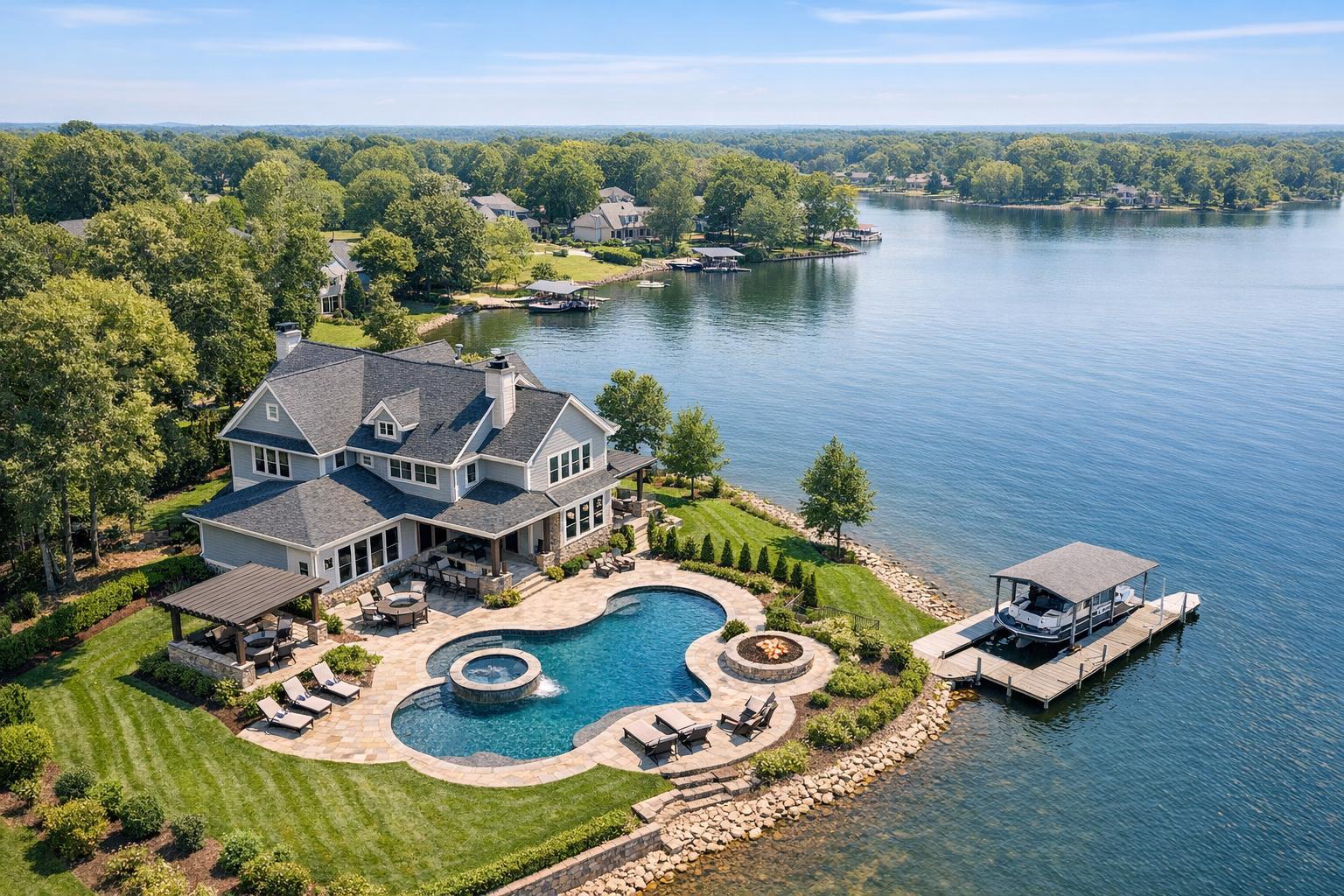
Drone photography captures a luxurious lakeside property featuring a pool, landscaped garden, and private dock with a boat.
When Is Drone Photography Worth Adding to a Real Estate Listing?
Drone photography real estate options have become a staple in modern property marketing, but we’re often asked: when does aerial media actually add value, and when does it simply add to the media package? Agents, brokers, and property marketers working in New York City and New Jersey have unique considerations. The built environment, airspace, weather, and goals for each listing all play a role in making an informed decision. Drawing on years of production for a range of property types, here’s a practical look at how to decide if real estate drone photography services are worth the investment—and what to expect when you book professionally.
Thinking Beyond the Hype: The Real Value of Aerial Media
Not every property needs drone photography, but there are cases where it provides a perspective ground-level cameras simply can’t match. The right aerial photo or video can help buyers, tenants, or investors visualize key details such as:
- The overall footprint or scale of the property compared to neighboring lots
- The boundary, size, and usable portions of exterior space
- Relationship to water, green space, or distinctive local features
- Access to roads, transit, or surrounding amenities
- Placement and approach for multi-building sites or commercial campuses
Drone media, when used intentionally, helps buyers answer location-based questions at a glance: How does the home relate to the backyard, pool, or waterfront? Where is the building in relation to the park? How easily can trucks access a commercial site?
Professional ground photography is still the anchor of almost every listing—it shows detail, layout, flow, and style. Aerial real estate photography complements this by providing context that’s only visible from above.
When Aerial Perspectives Make a Difference
Experienced real estate marketers know that not all listings benefit equally from drone imagery. Here’s where aerial media frequently proves its worth:
Homes With Significant Land or Outdoor Features
Detached homes on larger or irregular lots, properties with multiple structures, or homes showcasing pools, gardens, or defined boundaries are strong candidates. In these cases, a standard front exterior simply doesn’t tell the whole story. A well-planned aerial makes it easy to see how the home sits on the land, how amenities connect, and what makes the property unique.
Common scenarios that justify a drone shoot for residential properties:
- Large, landscaped yards that are hidden at street level
- Distinctive rooflines or architecture with an overhead component
- Bordering parkland, golf courses, or open space
- Outbuildings, detached garages, or guest houses
- Private drives or access points not visible from the street
The aim isn’t to exaggerate, but to represent what physically exists and help potential buyers understand value at a glance.
Waterfront, Lake, or Shore Listings
Homes on or near water nearly always benefit from a thoughtful aerial approach. Proximity to a beach, dock, or marina is a premium selling point—but a ground-level image often fails to communicate the true relationship. Drone photos can show if a property is truly waterfront, how it sits compared to neighbors, and whether there’s useful access to a shoreline or open water. This logic equally applies to listings on rivers, reservoirs, or golf course fringes.
New Construction and Large Developments
For marketing new communities, multifamily buildings, or full-block projects, only an elevated lens reveals the scale. Aerials document the current stage of construction, show roads, amenities, and site layout, and help orient buyers or investors to what’s actually in place. It’s crucial that aerial media aligns with reality: imagery shouldn’t promise amenities, landscaping, or features that aren’t completed at the time of capture.
Commercial and Investment Properties
Drone coverage can efficiently convey the functional aspects of a site—parking, entry, loading docks, access lanes, and the property’s position in relation to traffic and other businesses. For retail listings, showing the storefront, parking, and surrounding retail can help explain the value proposition clearly. In commercial settings, practical clarity often trumps pure visual drama.
When Drone Photography May Not Be Justified
That said, there are plenty of listings where aerial coverage offers little practical value. Among them:
- Apartments, condos, or co-ops where exterior access isn’t a selling feature
- Properties on small, closely packed city lots with minimal visible outdoor space
- Locations boxed-in by neighboring structures, distracting elements, or anything that would confuse the buyer
- Sites with no safe or compliant place to launch or fly a drone
- Dense neighborhoods—particularly in Manhattan and older sections of Brooklyn or Jersey City—where flight paths are restricted and rooftop options may not change the story told by ground images
For typical urban apartments, lobby or amenity areas, and interiors, invest in well-executed listing photography, a floor plan, and a clean video walkthrough. If a listing does include a terrace, rooftop, or rare skyline view and can be photographed legally and safely from above, case-by-case drone capture might be useful. But broad aerial packages for every unit rarely provide ROI.
Still Images, Video, or Both? Matching Delivery to Needs
The right format depends on what you want your listing to communicate.
Drone photos are typically best for providing instant context. One or two clear, thoughtfully composed images can define orientation, show the relationship to nearby points of interest, or highlight a unique amenity. A common mistake is overloading a gallery with redundant angles; a handful of intentional shots almost always has more impact than a dozen variations.
Aerial video is ideal when motion adds clarity. A smooth approach sequence can demonstrate access, or a gentle rise can reveal a hidden view. For larger properties or new developments, a coordinated video can set the stage before transitioning to interior movement. The difference between compelling video and a forgettable flyover is planning—sequences should be mapped in advance and aligned with property features, not captured randomly.
Local Considerations: NYC and New Jersey Drone Feasibility
Airspace, weather, logistics, and property access influence the decision to use drone media far more here than in many other regions. Commercial drone operations require FAA Part 107 compliance, and specific address restrictions, local ordnances, or even last-minute events can make a flight impossible on short notice.
- Manhattan: Consistent high-rise density, bundled airspace, active pedestrian zones, and evolving safety rules mean drone work is almost always a case-by-case call, not a default. Even with roof access, approval isn’t guaranteed.
- Other NYC Boroughs: Brooklyn, Queens, Jersey City, and Hoboken each pose their own mix of airspace and practical barriers, whether limited exterior room for takeoff or complex building patterns.
- New Jersey and Suburbs: While regulatory hurdles are sometimes lower, suburban properties with larger lots or water access offer more consistent opportunities for safe, valuable aerial capture—assuming weather, wind, and access cooperate.
Weather is a real-world issue: wind, rain, fog, or rapidly changing conditions can require a reschedule even on what looks like a straightforward shoot. Standby plans and flexible scheduling are a must for smooth execution.
Any project that needs permits beyond FAA authorization—municipal, NYPD, or event applications—must be handled by the client, as RealtaSnap does not pursue those clearances.
A Simple Decision Framework
Before booking drone photography, look at your property as if you were a first-time shopper seeing it online. Ask a few honest questions:
- Does the listing have outdoor amenities, land, or a feature that’s hard to visualize from the ground?
- Would an aerial truly clarify the layout, approach, or relative position to a local landmark?
- Is the relationship to the park, transit, beach, or commercial district central to your story?
- Can the listing legally and safely be captured from above based on current site conditions?
- Is it a commercial or development property where site context matters just as much as individual room details?
If your answer to most is “no,” strong ground-level photos and video should be the priority. For listings that do benefit from an aerial, the result should be purposeful, showing buyers what they need to see—not just another camera angle to fill out a gallery.
Operational Notes: Planning and Working With RealtaSnap
Every address brings different feasibility factors. RealtaSnap reviews requests for drone real estate photography or video on a case-by-case basis—and operates only when legal, safe, and practical at the site. Providing a full service address up front helps determine what’s possible and whether aerial capture will add genuine value to your media mix.
If you know you want to highlight a feature like a long driveway, water access, parking, or relationship to a neighborhood amenity, share that context when you book. Intentional communication helps us plan efficient flight paths and cover what will matter to buyers. All drone shoots are planned around what physically exists at the property.
For many listings, the most effective media combines exterior shots, interior photography, and targeted drone work to create a complete, accurate, and visually compelling presentation of both the property and its surroundings.
To schedule a drone session or review service options, visit RealtaSnap real estate media services. You can book online and select services, including drone, for properties in NYC, New Jersey, and approved surrounding markets. For listings where aerial content isn’t practical, all of our other ground-based photography, video, and specialty services remain available.
The most impactful listings use drone footage for clarity, not for novelty. Each asset should answer a real question for your audience.
Ready to plan your next listing’s media coverage? Learn more or get started at www.RealtaSnap.com.
FAQ
Question: Is drone photography useful for small homes or condos?
Answer: Drone shots can help if the home features outdoor amenities, a unique lot, water access, or architectural details that are easiest to appreciate from above. For small, interior-focused properties with limited exterior context, standard photos and video may prove more valuable.
Question: How do I know if my property can legally be photographed by a drone in NYC or New Jersey?
Answer: Drone feasibility depends on the exact location, airspace classification, current weather, site access, and safety. In some densely built areas, drone flights aren’t allowed at all. Suburban and waterfront areas are often more feasible. It’s best to provide the address upfront—RealtaSnap reviews each request for compliance and practicality before confirming a shoot.
Question: Should I replace my listing video with a drone video?
Answer: Drone video works best as a complement to ground-level listing video. Aerial footage can introduce the setting and context, while a standard video walkthrough presents flow and detail inside. Both formats have strengths, and combining them often delivers the most complete presentation for buyers.