When Is Drone Photography Worth Adding to a New Jersey Real Estate Listing?
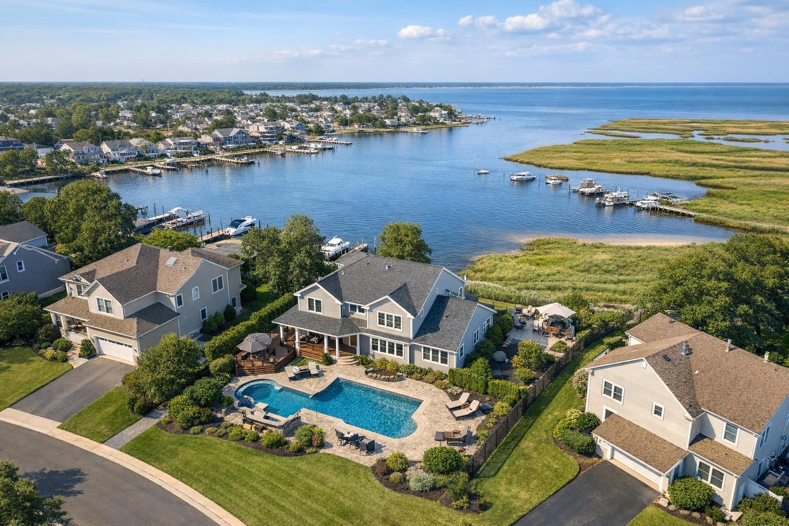
Drone photography in NJ captures a beautiful waterfront neighborhood with spacious houses, swimming pools, and a scenic view of boats on the water.
When Is Drone Photography Worth Adding to a New Jersey Real Estate Listing?
Drone photography in NJ is often searched by real estate professionals who want more than just impressive overhead shots. They’re aiming to answer a crucial question: will aerial media actually add meaningful value to a specific listing, or is ground-level coverage sufficient? As a real estate media team active across New Jersey and the greater NYC metro area, we’re continually weighing when drone imagery truly makes sense—and when it might just be an attractive extra.
This editorial is our practical field guide to understanding when drone photos or video are the right fit, what aerial coverage delivers that ground media cannot, and how experienced providers approach each shoot. Whether you’re marketing a roomy Bergen County backyard, a Jersey Shore retreat, an urban multifamily, or a flexible-use commercial site, here’s what you need to know.
Why (and When) Aerial Real Estate Media Stands Out
Professional ground-level photography remains the foundation for almost any New Jersey listing. Room presentation, curb appeal, and the experience of living in a space are still captured best by a skilled on-site team. But there are many cases where a listing’s strongest selling points are difficult to communicate at eye level. That’s where aerial real estate media—photos, video, or both—become a strategic tool rather than just another visual.
When aerial media adds clarity:
- The size, shape, or placement of a lot isn’t obvious from the ground
- Rooflines, exterior amenities, or landscaped features are important to the story
- Proximity to water, transit, parks, or main roads matters to buyers or tenants
- The relationship between buildings, parking, and outdoor areas could tip a decision
- The scale of a site (especially with commercial, multifamily, or mixed-use properties) is hard to appreciate otherwise
A clear, well-composed drone shot can often answer the big “where?” and “how much?” questions that prospective buyers or renters have before they ever see the property in person.
Properties That Typically Benefit From Drone Coverage
Not every real estate listing justifies the added investment in drone work, but some types of properties are naturally well-served by the extra perspective.
Suburban Homes and Estate-Style Properties
For larger lots, multi-zone yards, or homes with detached structures, drone photography quickly shows relationships that ground shots can’t: the winding driveway, the footprint of a garden or pool, the privacy offered by landscaping, or how accessory structures connect to the main home. A couple of well-angled aerials can instantly communicate what makes a property special—and avoid buyer confusion about scale, separation, or layout.
Shore and Waterfront Real Estate
New Jersey’s shore homes, bayfronts, and marina-located properties are obvious candidates for aerial perspective. Ground-level photography can capture water views from inside, but only a drone can show how close the beach is, how the path winds to the water, or how expansive the view really feels. In these cases, setting isn’t just a backdrop—it’s the main event.
Multifamily Buildings and Condo Complexes
Drone imagery isn’t just for detached residences. For urban and suburban multifamily listings, aerials can reveal the building’s position within the block, the arrangement of parking and common areas, and the proximity to transit, retail, or green space. The more a property’s value is connected to external environment or amenities, the more likely aerial media pays off.
Commercial Sites, Retail Centers, and Mixed-Use Buildings
Drone media excels when site access, lot layout, and street presence matter. Some of the most practical drone assignments involve showing:
- Retail visibility and parking access
- Loading zone configurations
- Office campus layout
- Warehouse or distribution site scale
- The relationship between a commercial property and nearby highways or transit routes
Here, a single photo or a few seconds of video can do more than a detailed description ever could.
When Ground-Level Photography Is Still the Best Storyteller
Drone coverage isn’t automatically useful for every listing. There are plenty of situations where aerial images add little value, and a solid package of interior and exterior photos is the better investment:
- Townhouses or condos without notable exterior space
- Smaller homes where the best features are inside
- Urban infill properties where tight spacing makes lot boundaries unclear
- Properties whose “story” is the interior renovation or thoughtful layout
In these instances, the decision is simple: ground-level media can communicate almost everything a buyer or renter needs to know.
Choosing Still Photos, Video, or Both
One common question is whether still drone photography, aerial video, or a mix of both is the right move.
- Aerial stills: Most effective for properties where a single image can answer the location, lot size, or amenity question. These photos can be studied at a buyer’s own pace and often serve as strong lead visuals in gallery carousels.
- Aerial video: Useful when movement or narrative adds value—think a video that glides from the bay toward a shore home, or circles a commercial complex to show ingress and egress. Video works best when intentionally sequenced in the listing, so viewers aren’t just seeing a fast-moving tour but actually understanding site context.
- Both formats: Some properties (particularly spacious homes, major developments, or commercial listings with multiple features) simply need both. Stills capture the permanent reference points while video offers a wider sense of movement and relationship.
At RealtaSnap, drone photo assignments in New Jersey are available as:
- 10 HDR photos: $209
- 1-minute final 4K drone video: $229
- Combined drone photo and video: $299
These options allow clients to tailor coverage to the needs of each listing.
Practical and Operational Considerations
Adding real estate drone photography isn’t just about booking the service—it’s about ensuring the shoot is actually feasible and will deliver usable results.
Flight Feasibility
- All drone media is subject to FAA Part 107 rules, airspace restrictions, and pilot discretion
- Weather, overhead wires, tall trees, nearby airports or heliports, and site access may affect the ability to fly
- Urban areas sometimes require additional authorization or may limit the safe flight envelope
- Feasibility is determined on a case-by-case basis; some sites may need to be rescheduled or adapted, particularly in denser environments
Preparation Steps
- Move any vehicles if open driveways or parking are important to the shot
- Tidy outdoor spaces, store loose items, and prioritize cleanup of pools, patios, decks, and gardens
- Secure gates, fences, umbrellas, and pool covers as needed
- Notify your media team of any access codes, shared spaces, or property management requirements in advance
Clear communication about what features matter most—whether it’s water access, acreage, a rooftop deck, or site lines to a highway—helps the team compose impactful aerials.
A Simple Guideline: Does the View From Above Add Clarity?
If you’re weighing the value of drone media for a listing, ask yourself: “Will an aerial image make something about this property clearer to a potential buyer or tenant?” If the answer is yes—because of land, water, views, access, amenities, or scale—then aerial coverage is likely justified. If not, focus your investment on strong ground-level coverage that shows the living spaces, finishes, and everyday experience the property offers.
Working With a Professional Provider
Real estate drone photography in New Jersey is a regulated service requiring knowledgeable providers and thoughtful planning. At RealtaSnap, aerial media is offered only for eligible listings and in line with operational, airspace, and safety requirements. We do not conduct architectural or engineering inspections and do not provide legal property boundaries in our photos.
Booking is completed online, and flight feasibility is always reviewed for each address and shoot date. For more information about our drone and other real estate media services, or to schedule coverage for an upcoming listing, visit RealtaSnap’s NJ real estate media page.
FAQ
Question: How many drone images does a real estate listing actually need?
Answer: For most listings, a small set of purposeful aerials is much more useful than a folder of similar overhead shots. The goal is to clearly communicate the lot, relationship to surroundings, and any exterior features that can’t be explained with ground photography.
Question: Will drone photos show property lines or lot boundaries?
Answer: While drone images provide helpful context, they do not legally determine property lines. If an exact boundary is required, always rely on a proper survey or verified documentation—the drone aerials are for marketing perspective only.
Question: Can I add drone video and photo coverage to my standard media package?
Answer: Yes. With RealtaSnap, drone photos, video, or a package including both can be added during the booking process. Each request is evaluated based on property location, access, airspace, and weather. For booking details, see RealtaSnap’s booking information or reach out if you have specific flight feasibility concerns.
For customized guidance or to discuss what will serve your next New Jersey or NYC listing best, visit www.RealtaSnap.com.