When Is Drone Photography Worth Adding to a New Jersey Real Estate Listing?
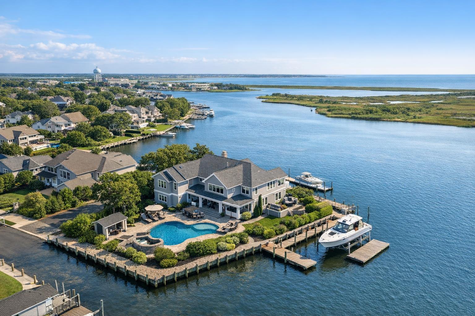
Drone photography in NJ captures a stunning waterfront property with a large house, pool, and private docks along a serene inlet.
When Is Drone Photography Worth Adding to a New Jersey Real Estate Listing?
Drone photography NJ agents consider is rarely just about creating a “wow” effect. More and more, the question comes down to this: when does aerial real estate media deliver practical value for a listing—value that goes beyond the standard ground-level photos?
Real estate professionals working in New Jersey, and by extension, the dense urban fabric of NYC and its surrounding suburbs, often wonder: Does this listing need an aerial perspective? Or is standard professional photography enough? It isn’t always obvious, but the answer can shape not only your media budget, but how clearly your listing communicates to potential buyers.
Aerial View: Context Over Drama
With drone photography, the most meaningful benefit isn’t always spectacle—it’s context. From above, a camera can clarify relationships that are impossible to record from the sidewalk. Aerial real estate media allows you to show:
- How a home is situated on the lot
- Its proximity to community features (parks, beaches, transit, retail)
- Usable land and outdoor amenities like pools, gardens, and patios
- The position of multifamily or commercial buildings in relation to streets and parking
- Waterfront frontage, docks, and skyline or bay views
Aerial images are at their most effective when they answer lingering questions a buyer might have—questions that a curbside shot can’t resolve. If the drone angle doesn’t clarify something unique about the property, it’s often just a pretty extra.
Which Listings Actually Benefit From Drone Coverage?
Not every New Jersey home or commercial property gains value from aerial shots. Here’s how we break down the decision as a real estate media team covering such a varied region.
Larger Lots, Estates, and Suburban Properties
For homes set on significant land—think of the generous lots common in north and central Jersey, or semi-rural estates—aerial perspectives can be a game-changer. They make it easy to show:
- Expansive backyards, gardens, pools, or multiple terraces in a single frame
- Outbuildings like guest houses, barns, or detached garages
- Property boundaries and privacy created by distance or foliage
- Long or scenic driveways, unique approach angles, or estate gates
These features often drive a buyer’s interest but are tough to capture from ground-level. On a more modest lot tightly bordered by neighboring homes, standard exterior photography almost always does the job more succinctly.
Jersey Shore and Waterfront Homes
Throughout the Jersey Shore and along New Jersey’s rivers, lagoons, and bays, buyers often want proof—visual proof—of waterfront access, dockage, walkability to beaches, and sightlines to open water. Aerial images are uniquely suited to:
- Showing exactly what “waterfront” means at that address
- Illustrating the orientation of a home relative to beaches, boardwalks, and marinas
- Revealing roof decks or elevated terraces that open to ocean, bay, or city views
- Displaying the layout of outdoor amenities in context with the shoreline
Intention matters: a distant overhead photo risks getting lost, while a thoughtful sequence—tight to wide—makes the property’s context both clear and inviting.
Distinctive Rooflines, Decks, and Architecture
Some buildings are best understood with a view from above or at elevation. These often include:
- Modern homes and innovative architecture with complex geometric rooflines
- Properties built into hillsides or bluff-top sites where approach and levels matter
- Rooftop spaces and decks that define the property’s appeal
- Architectural features (dormers, skylights, solar panels, or green roofs) otherwise hidden from the curb
That said, not every architecturally unique home calls for a drone. If the primary selling point is its street presence or high-end interiors, a strong traditional photo set may be just as effective.
North Jersey Multifamily and Urban Developments
Dense multifamily buildings, particularly in places like Jersey City, Hoboken, or the suburbs closest to Manhattan, occasionally justify drone media. Aerials can help establish:
- The placement of a building within its block or neighborhood
- Access to transit and main roads
- Shared amenities like rooftop lounges, parking, or courtyards
However, urban flights bring practical hurdles: tight airspace, crowded surroundings, heavy pedestrian or vehicle traffic, and sometimes limited or no launch areas. Detailed feasibility reviews are mandatory for these projects.
Commercial Sites
For commercial properties—especially office parks, warehouses, shopping centers, and land parcels—aerial images can convey information almost impossible to get from the street, such as:
- The scale and footprint of the property
- Parking lot size, access points, loading docks, and adjacent roadways
- Proximity to major highways, train lines, or business districts
Again, aerials should be purposeful: a high vantage point that demonstrates road access or property scale often delivers more value than a generic “cinematic” overhead.
When Is Ground-Level Photography Enough?
The temptation to add drone coverage to every listing is strong, but it’s not always practical or necessary. Ground-level exterior photography might be all you need when:
- The lot is standard-sized, with few distinctive exterior features
- The home is tightly nestled among its neighbors, making aerial isolation difficult
- Selling points are primarily indoors (e.g., renovations, kitchen upgrades, or master suite improvements)
- There’s no remarkable view, significant land, or water relationship
- An aerial would only show rows of rooftops or uninspiring streetscape
Professional exterior photos, well-lit and carefully composed, can tell a much stronger visual story for condos, apartments, townhomes, and smaller single-family homes than an obligatory drone shot.
Deciding on the Right Aerial Coverage
Drone media is about more than clicking “add-on” when scheduling a shoot. Before booking, take a few minutes to think through your listing’s actual needs.
What to Ask Before Booking Aerials
- Does the property have outdoor features, land, or views that ground-level photography cannot adequately capture?
- Would a buyer benefit from an overhead or elevated perspective to understand the setting, scale, or amenities?
- Is the property’s location, access, or airspace likely to support a safe, legal drone flight?
If the answer to any of these is “yes,” it may be worth considering aerial coverage for your next shoot.
Practical Realities: Regulations, Safety, and Feasibility
Aerial work is always subject to very real constraints. Even with agent interest and the right property, several factors dictate whether a drone launch is possible:
- Airspace: Some areas—especially urban cores near airports—require specific FAA authorization, or may be restricted entirely.
- Weather: High winds, rain, haze, or low visibility call flights off for safety and quality reasons.
- Launch/Landing Space: A drone operator needs safe clearance for takeoff and landing; small yards, busy sidewalks, or crowded developments limit options.
- Access: Roof or private area access can sometimes create special opportunities for capture in dense settings.
- Local Rules: Permits may sometimes be required for commercial drone work, especially at public events or municipal properties. RealtaSnap does not obtain local, NYPD, or special event permits; clients are responsible for securing these if necessary.
- Pilot Discretion: Final call always rests with an experienced, FAA-certified pilot working in compliance with law and safety.
For every scheduled shoot that includes drone media, RealtaSnap conducts a property-by-property feasibility review. We only proceed when conditions are right for a safe, listing-focused flight.
Maximizing the Value of Your Aerial Coverage
To ensure aerial photos and video provide clear value, careful preparation is key:
- Remove vehicles from driveways and tidy up yards, patios, and pool areas
- Put away trash bins, hoses, or visible clutter that stands out from above
- Ensure access to gates, docks, or rooftop spaces if they are central to the listing
- Share notes about features that matter, such as rear acreage, deck orientation, or critical view corridors, before the shoot
In practice, aerials work best when integrated: a ground-level front photo might showcase curb appeal, while the aerial locates the home within its lot, land, or waterfront. Each media type should reinforce—not duplicate—the listing’s core story.
RealtaSnap’s Approach for NJ and NYC Listings
Every property is different, and every drone shoot is carefully considered by our team—never promised by default. RealtaSnap provides professional aerial media for listings across New Jersey and all five boroughs of New York City, always according to FAA rules, local ordinances, safety, access, and actual conditions at the property.
Aerial photo packages (10 HDR images, with sky replacement if needed) start at $209. A one-minute final 4K aerial video is available for $229, or you can choose both for $299. If you have a property where aerial views could clarify the layout, scale, amenities, land, or views, learn more or schedule a shoot.
Call to Action
If you’re planning a New Jersey or NYC listing and want focused, professional aerial media when conditions allow, RealtaSnap can review what’s possible for your address. See all service options and book directly at www.RealtaSnap.com.
FAQ
Question: Do I need to schedule drone photography separately from my standard shoot?
Answer: For most properties, it’s easiest to add aerial coverage at the time of booking. When scheduling with RealtaSnap, include the property details and note any essential features—our team will review drone feasibility as part of the appointment.
Question: Is aerial media guaranteed for every listing?
Answer: No. Drone flights are approved on a case-by-case basis, factoring in airspace restrictions, weather, safety, and access on the day of the shoot. A safe, legal, and effective capture is always the priority.
Question: What kinds of New Jersey properties see the most benefit from aerial photos or video?
Answer: Larger lots, homes with significant outdoor amenities, waterfront and shore homes, commercial sites, and multifamily properties with extensive outdoor, rooftop, or parking areas are typically the strongest candidates for aerial media. Condos, standard-sized lots, or spaces where exterior elements aren’t a focus may not need drone coverage.