The Role of Drone Photography in Enhancing NYC Property Listings for Agents
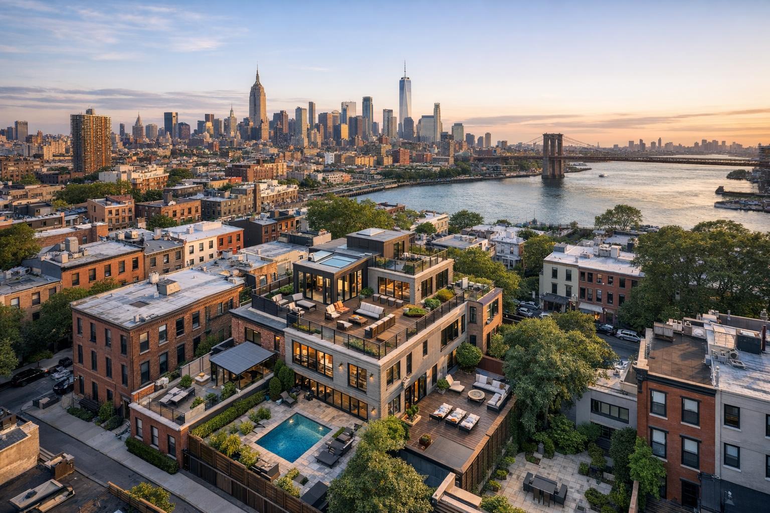
Drone photography captures the stunning NYC skyline at sunset, overlooking a charming residential neighborhood and the Brooklyn Bridge.
Drone Photography NYC: Transforming Real Estate Listings with Professional Aerial Imagery
In today’s real estate market, drone photography in NYC has become a must-have for ambitious agents, hosts, and property managers. As search platforms grow more visual and competitive, high-quality aerial real estate photography is essential for showcasing properties in ways that stand out from the crowd. In this article, you’ll learn why aerial imagery matters, practical hurdles real estate professionals face, the value of working with an experienced in-house drone team, and how RealtaSnap turns technical expertise into real marketing results for your listings .
The Real-World Problem: Why Conventional Photography Falls Short
For many New York City and New Jersey agents trying to boost listing views, the limitations of standard ground-level photography are immediate and painfully familiar.
Typical challenges include:
- Crowded urban environments that make it tough to capture building context or surrounding amenities
- Listings that blend in, with front façade shots indistinguishable from dozens of neighboring properties
- Dim, uneven lighting—especially in deep brownstone units or high-rises—leading to uninspired photos
- Unflattering angles that make even beautiful spaces feel cramped or lackluster
- Digital platforms where buyers quickly scroll past unimpressive or noisy thumbnails
- Leasing clients and new development teams needing to sell a lifestyle as much as a floor plan
Agents often find that even a well-composed interior photo gallery can’t convey proximity to the park, a sweeping rooftop view, the privacy of a backyard, or the drama of a newly renovated penthouse. Straightforward ground shots struggle to reveal skyline perspectives or give buyers the scale and setting that drive excitement. Worse, weak imagery results in lower click-through rates, sluggish inquiry volume, and inconsistent branding across portfolios.
What Experienced Media Teams Know: The Realities of Listing Photography
After years photographing everything from pre-war co-ops to Jersey City duplexes and Manhattan mid-rises, we’ve seen firsthand how the right visual strategy can change not just engagement numbers, but agent workflow and client satisfaction.
Here’s what industry insiders understand:
- Timing is everything: The difference between mundane and magical light in an aerial shot can be just a 20-minute window—especially with east- or west-facing rooftops.
- Preparation counts: Cluttered rooftops, unfinished terraces, or construction bins can ruin the value of a bird’s-eye view. Seasoned teams alert agents days beforehand to clear these up.
- FAA compliance isn’t optional: In NYC, complex airspace and city restrictions mean only certified pilots can operate legally and safely. Anyone skipping real licensing is risking steep fines, legal issues, and liabilities.
- Post-production is decisive: Urban drone photos require careful balancing of vertical lines, exposure through windows, and sky detail correction to avoid washed-out or underexposed images.
- Workflow matters: Busy agents depend on predictable, fast delivery. Aerials are often needed urgently—delays can mean missing critical live dates or the first wave of buyer interest.
Professionals know an aerial session is more than a quick flyover. It’s a blend of compliance, coordination, art direction, technical mastery, and client service—especially in an environment as demanding as NYC.
How RealtaSnap Solves It: Professional Drone Media That Delivers
At RealtaSnap, we’re deeply familiar with the challenges agents face in making their listings command attention. Our in-house drone photography team works daily in New York City and New Jersey, bringing technical rigor and creative vision to each project. Here’s how our approach addresses your needs:
- Tech and Certification: Every shoot is conducted by an FAA-certified pilot with deep knowledge of both federal and local NYC airspace requirements. We handle all permitting and safety compliance, so you’re never at risk.
- Easy Booking, Clear Pricing: Book your drone photography online in under five minutes. Packages start at $199 per property, with transparent, up-front pricing—no surprises or added licensing fees. All prices and information are subject to change. Information is deemed reliable but not guaranteed .
- Pro-Grade, Next-Day Turnaround: We guarantee professionally edited drone photos for real estate back to you within 24 hours, including retouching for vertical alignment, optimal sky replacement, and detail preservation.
- Workflow-Driven Prep: Our team sends pre-visit checklists so agents can prep rooftops, terraces, and exteriors for optimal results. After the shoot, a dedicated editor ensures every image meets MLS and branding standards.
- Media That Sells: Our photographers know how to highlight property proximity (parks, subways, business hubs), amenities (shared roof decks, pools, private gardens), and features that grab online browsers—whether it’s a historic Brooklyn brownstone or a sleek Hoboken tower.
No matter the project, we’re built for speed, quality, and reliability—delivering drone photos for real estate that don’t just look good, but drive measurable listing engagement.
Benefits of RealtaSnap Drone Photography
- FAA-certified pilots ensure legal and safe operations in tough NYC airspace
- 24-hour turnaround means listings go live faster
- Images highlight property location, amenities, and unique angles
- Online booking takes less than five minutes
- No hidden fees—package pricing is up front
- Consistent, high-level editing on every deliverable
- Prep and shoot checklists included for agent peace of mind
- MLS-compliant files ready for upload
- Stunning aerials boost click-through and inquiries
- Local expertise in NYC, New Jersey, and the region
Why This Matters in the NYC / NJ Market
The New York/New Jersey market is fiercely competitive—not just for buyers, but for the attention of online shoppers and platform algorithms. In Manhattan, Brooklyn, and Jersey City, listings can vanish into a tidal wave of new uploads. Brownstones, prewar buildings, and tight-lot developments need context: Where’s the green space? What’s the skyline view? Does this roof deck offer real privacy or a view straight into a neighbor’s apartment?
Aerial real estate photography answers these questions instantly, helping buyers imagine themselves in a space—and, crucially, motivating them to click for more details. In suburban New Jersey or along the Gold Coast, drone imagery highlights proximity to commuter trains, parks, and school districts—points often missed in interior galleries.
Comparison with Traditional or Lower-Quality Alternatives
- Phone Photos: Ground-level phone shots typically lack the dynamic range, color accuracy, or wide perspective needed to show off full property scale. Most can’t correct lens distortion, and lighting is rarely balanced for exteriors.
- Rushed or Inconsistent Media: Aerial work done without flight prep or proper permits can result in images that are off-kilter, overexposed, or missing crucial selling features entirely. We’ve seen “drone” photos with garbage bins in full view because the agent wasn’t briefed ahead of time.
- Delayed or Incomplete Delivery: Photography providers who outsource editing or juggle too many projects often can’t promise reliable delivery times. Even a 48-hour delay can mean lost momentum—and disappointed waiting sellers.
- Generic Providers: Those unfamiliar with local property types might miss key amenities (like shared gardens, bike storage, or unique roof elements), delivering images that feel cookie-cutter and fail to tell the property’s story.
RealtaSnap counters each of these pitfalls with a dedicated, local team, hands-on prep, custom editing, and a workflow designed for the realities of selling or leasing in NYC and NJ.
Conclusion & Call to Action
Aerial imagery is no longer optional in New York and New Jersey’s hyper-competitive real estate space—it’s essential for making properties perform online. Whether you’re listing a Park Slope brownstone, Jersey City multi-family, or SoHo penthouse, RealtaSnap’s in-house drone media team delivers the detail, speed, and reliability today’s market demands.
Ready to elevate your listings above the rest? Explore our aerial real estate photography services and book online today{:target="_blank"} for transparent pricing and jaw-dropping visuals. See why so many NYC-area agents trust RealtaSnap to make their listings shine .
Frequently Asked Questions
1. Are drone photos for real estate legal in NYC and NJ?
Absolutely, as long as the flights are performed by FAA-certified pilots and all city, federal, and property-specific regulations are followed. RealtaSnap’s drone operators are fully licensed and handle all compliance and permitting—giving you total peace of mind that your imagery is safe and legal.
2. How fast will I receive my edited aerial images after the shoot?
You’ll get your professionally edited aerial gallery within 24 hours of the shoot. Our in-house team expedites every step, so your listing never waits on media delivery—letting you move fast and hit critical market windows with confidence.
3. What makes RealtaSnap’s process different from generic drone or media vendors?
Unlike one-size-fits-all providers, RealtaSnap combines local NYC/NJ expertise with an in-house editorial process and advance prep. You get not just great drone shots, but images tailored to your listing, your brand, and your timeline—all with the support of an experienced team who’s been there.
Learn more about RealtaSnap’s full photography and video offerings here{:target="_blank"}. All prices and information are subject to change. Information is deemed reliable but not guaranteed.