The Impact of Drone Photography on Real Estate Marketing Strategies in NYC
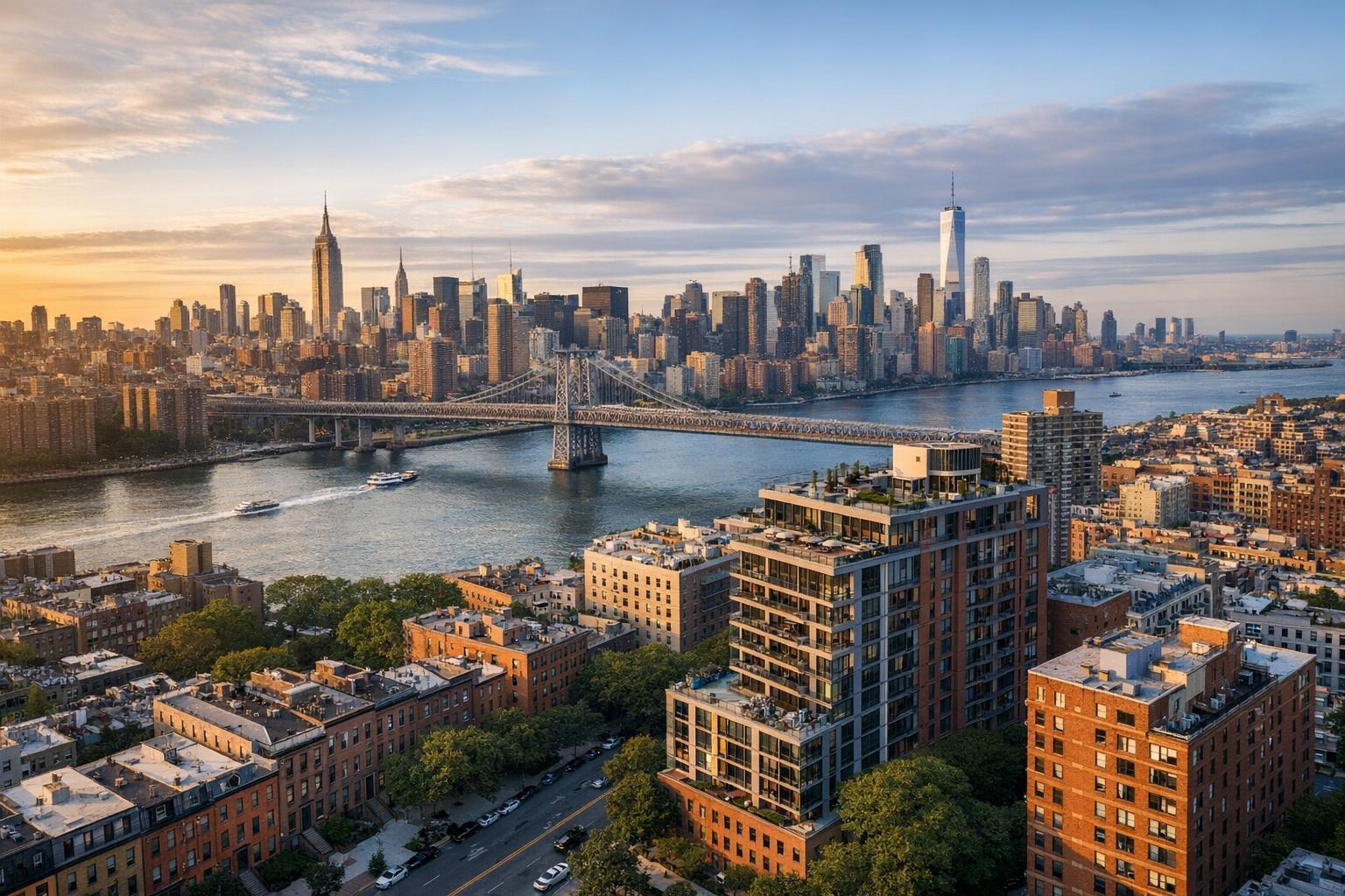
Drone photography captures a stunning view of urban real estate with iconic skyscrapers and a bridge spanning the river.
Why Drone Photography is Revolutionizing Real Estate Marketing in NYC
Drone photography real estate services have ushered in a new era for property marketing, especially in dense, visually complex markets like New York City and New Jersey. Aerial imaging reveals context and scale in ways that traditional ground-level photographs and videos rarely can, providing a clear sense of where a property sits within its neighborhood, its proximity to parks or skyline vistas, and the relationship between exterior features like backyards or rooftops.
This context matters because buyers and renters increasingly expect more than a series of attractive interior images. For listings where location, outdoor space, building scale, or unique setting play a significant role, drone imagery fills critical informational gaps, helping agents and property owners present a full story—one that moves beyond the front door.
Context is Everything: What Aerial Imagery Adds
Standard real estate photography excels at showcasing interiors, finishes, and the living experience inside a property. But it is often limited when exterior features or neighborhood context are key selling points. For example, a set of ground-level images might hint at a terrace or garden, yet fail to capture its scale, placement, or how private the space feels in relation to neighboring lots.
With drone photography, it’s possible to step back—sometimes literally hundreds of feet—and provide:
- A clear overhead or oblique view of a home’s full lot, outdoor areas, and outbuildings
- Visual proof of expansive yard space, a pool area, driveway access, or a rooftop terrace
- The property’s relationship to city parks, waterfronts, green belts, or local landmarks
- The character and scale of building exteriors in architectural settings as varied as Brooklyn brownstones, Staten Island waterfronts, or suburban-style houses in New Jersey
- A true sense of a property’s position within its block or neighborhood
The most effective aerial photos and videos are not simply high-altitude snapshots—they are planned, property-specific, and answer the most significant questions a buyer might have about scale, location, and surroundings.
Why Drone Visuals Matter in NYC, New Jersey, and Surrounding Markets
No two properties in the NYC or NJ region are exactly alike—and neither are their marketing needs. Drone photography is particularly useful when a property has features or context that standard photography can’t sufficiently communicate.
Distinctive Advantages for Townhouses and Detached Homes
Properties with private outdoor features, such as backyards, terraces, driveways, or corner lots, benefit from drone capture. Aerial photos and videos make it easy to present:
- How outdoor and landscaped spaces flow together
- The accessibility of garage or driveway entryways
- Architectural features only visible from above or at height
On the New Jersey side, where single-family homes and broader lots are common, this large-scale perspective is often crucial. Viewers can quickly grasp the amount of usable land and external amenities.
Elevation for High-Rises and Rooftop Properties
For penthouses, high-rise condos, and buildings with rooftop amenities, aerial content highlights skyline views, roof decks, pools, and terraces in the context of surrounding streets or city features. This is especially valuable when an outdoor amenity is a selling focal point. Rather than isolated close-ups, drone images tie these amenities into the overall living experience by showing their connection to views, parks, or the river.
Supporting New Developments and Multifamily Marketing
When developers or leasing teams launch a new building or residential community, they need to demonstrate not just units and amenities, but also how those assets sit within a wider neighborhood, open space, or transit network. Drone video and photography can anchor these narratives, helping prospects understand everything from nearby parks to the relationship between several buildings on one parcel.
Commercial Listings and Mixed-Use Properties
Aerial viewpoints are valuable for showing parking, site access, building presence, and neighboring infrastructure—key factors for prospective commercial tenants or investors who need to understand foot traffic, logistics, or future development sites.
Drone Video: Adding Motion and Sequence
While still aerial photographs function as essential visual references, drone video adds kinetic energy—helping audiences experience an “arrival” sequence or transition from cityscape to property. For instance, a video might start broad, with a flyover of the neighborhood, then hone in on the roof deck, exterior facade, or entryway.
The impact is especially strong for listings featuring:
- Expansive land or outdoor settings
- Prominent exteriors or architectural details
- Scenic sites near parks, water, or unique streetscapes
- Large campuses or multifamily complexes
Thoughtful drone video does not require exhaustive footage from every angle. Instead, a handful of purposeful aerial sequences can establish key information—location, approach, notable exterior amenities—without distracting from the interiors.
Answering Key Buyer and Renter Questions With Aerial Media
Effective drone photography starts well before the drone leaves the ground. It requires identifying which aspects of a property will actually benefit from a bird’s-eye perspective, and which questions need to be answered visually. Some common considerations include:
- How does the entirety of the property appear in context?
- Is the backyard, terrace, or deck truly private?
- What can be seen from outdoor areas?
- How close is the property to parks, open space, or waterfront?
- How does the building sit on its lot or block?
- Are there distinctive exterior features that need a wider visual frame?
The best aerial shot addresses a question likely to matter to a motivated buyer or renter, and sets realistic expectations. For example, a property next to a city park may warrant drone capture showing proximity to green space—but only if that relationship is clear and direct from the sky.
Integrating Drone Media With Other Listing Content
Aerial real estate photography is rarely a complete solution in isolation. Instead, it should fit into a coordinated media approach that lets buyers visualize the entire property experience. In practice, most effective real estate media packages combine:
- HDR interior and exterior photos for clarity and detail
- Targeted drone photos and/or drone videos for context and site narrative
- 3D virtual tours or property videos for interior flow and movement
- Floor plans for spatial reference
Compact units or apartments where outdoor space or views are not selling priorities may not benefit from drone media. However, for townhouses, larger lots, properties with meaningful exterior assets, or listings requiring geographic context, aerials can turn a static catalog of images into a holistic story.
RealtaSnap offers a range of services to ensure media coverage is tailored to each property’s unique strengths. Agents and property owners can coordinate all media—photography, 3D tours, floor plans, and drone photography and video—to maximize relevance and visual impact.
Operational Realities: How Drone Services Work in NYC and NJ
The decision to use drone media comes with logistical and regulatory considerations unique to this region. In New York City and New Jersey, every drone flight is subject to airspace restrictions, weather conditions, safe launch/landing zones, and building or property access.
- All RealtaSnap drone operations comply with FAA Part 107 rules.
- Some locations are not suitable for drone flight, especially in dense or controlled airspace.
- Roof access can improve feasibility, but cannot guarantee a flight will be possible.
- Clients are responsible for any additional permits if required; RealtaSnap does not secure municipal, NYPD, or special-event flight authorizations.
- Each project is assessed for safety and may be declined if conditions are unsuitable.
Drone services are strictly for marketing purposes—they are not substitutes for architectural surveys or engineering inspections.
Preparing for a Successful Aerial Shoot
A bit of on-the-ground preparation can make a significant difference in the outcome:
- Ensure driveways, patios, decks, and rooftops are clear of clutter and maintenance items
- Stage outdoor furniture as it is intended for use
- Mow lawns and address visible landscaping when applicable
- Confirm access for roofs, yards, or gated entries in advance
- Alert any building staff who need to grant access or coordinate on the day of the shoot
- Identify which exterior features and angles deserve priority coverage
Sharing relevant access notes and property information during booking can help teams make practical decisions about flight paths, especially for rooftops, courtyards, or unique site logistics.
Is Aerial Coverage Right for Your Listing?
Drone photography is most useful when it helps a prospective buyer or renter see the big picture—literally and figuratively. Consider adding aerial coverage if your property features:
- Substantial outdoor space or land
- Roof decks, terraces, or distinctive exteriors
- Waterfront or park-side settings
- Multifamily or development sites
- Locations where external context is part of the narrative
If these factors apply, well-executed drone media can clarify a property’s physical reality and give audiences a fuller, more memorable impression of its setting.
RealtaSnap serves all five boroughs of NYC, the entire state of New Jersey, and select markets nearby. To explore which drone options fit your listing or to schedule, visit the RealtaSnap scheduling page or explore current drone photography packages.
Current Drone Photography Rates
- Drone Photography (10 HDR Photos, 1 hour): $209
- Drone Video (1 minute, 1 hour): $229
- Drone Photo & Video (10 HDR Photos + 1 minute video, 1 hour): $299
Pricing and package details are always available on the official drone services page.
Ready to Book?
Drone photography real estate services can transform the way your listings communicate value and context to buyers and renters. If you’re interested in seeing how aerial imagery could fit in your marketing strategy—or have questions about feasibility in your area—learn more at www.RealtaSnap.com.
FAQ
Question: Can drone photography be used for every NYC or NJ property?
Answer: Not always. Feasibility depends on factors like airspace regulations, launch zones, weather, and property access. Roof access can increase options, but pilot and site safety remain the final word on whether a flight can proceed.
Question: What types of real estate benefit most from aerial imagery?
Answer: Listings with notable land, outdoor amenities, terraces, roof decks, or unique settings—such as development sites or waterfront properties—see the greatest impact from aerial photos and videos, especially when context helps a buyer understand scale or location.
Question: What is the process for booking drone services with RealtaSnap?
Answer: Booking starts by entering the property address, choosing services, and adding any access instructions on the RealtaSnap scheduling page. Booking is subject to 24-hour advance notice and may require additional steps for special site access or permits.