The Impact of Drone Photography on Real Estate Marketing in NYC and NJ
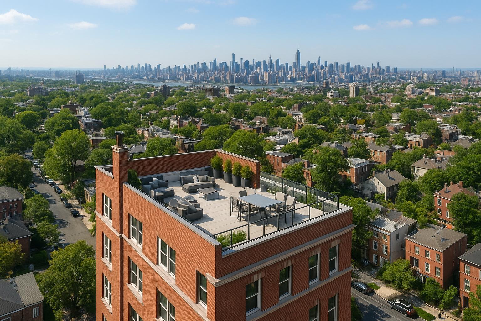
Drone photography captures a vibrant urban landscape featuring a prominent building with an inviting rooftop terrace, set against a sprawling city skyline.
How Drone Photography Real Estate Is Transforming Marketing in NYC and New Jersey
Drone photography real estate is redefining how properties are seen, marketed, and sold in NYC and New Jersey’s fiercely competitive landscape, especially as more buyers begin their search online using terms like “best real estate photographers NYC” and “drone photography NYC.” In this article, we draw on our hands-on experience as a real estate media company to share how aerial real estate photography is changing the game — from buyer engagement and property value perception to practical, operational truths every agent or seller needs to know. You'll learn why drone services matter, what regulations come into play, and how RealtaSnap delivers reliable, compliant, standout results that help listings shine above the rest.
The Real-World Problem
Real estate marketing in NYC and New Jersey isn’t just about getting your listing online — it’s about making sure your property is the one that stops a thumb or starts a conversation. Agents, property managers, and sellers know the pain points:
- Listings with standard ground-level photos often blend into endless search results, leading to low click-through rates and missed opportunities.
- First impressions are lost in dark, cramped, or awkwardly angled photos, especially for urban condos, multifamily buildings, or homes on tight lots.
- Buyers scroll past images that fail to capture scale, curb appeal, or unique features — especially rooftops, outdoor amenities, or dramatic views.
- Commercial properties and high-end homes look unremarkable from the ground, weakening their branding and failing to inspire buyer imagination.
- Inconsistent or amateur media (using smartphones or outdated techniques) introduces risk, fails to reflect the property accurately, and costs agents in reputation and time.
- Subpar visuals delay buyer inquiries, increase time on market, and – in busy urban markets – can mean the difference between multiple offers and a listing that lingers.
In dense environments like Manhattan or Jersey City, showcasing lot lines, air rights, proximity to landmarks, and building amenities is nearly impossible without aerial visuals. Without drone photography, key features (such as a private garden, rooftop terrace, or total property size) are left unseen or misunderstood.
What Experienced Media Teams Know
After photographing and filming hundreds of NYC and New Jersey listings, we’ve seen the difference drone work makes:
- The right aerial angle can instantly communicate a property's context — revealing where it sits in relation to parks, transit, skyline, and more.
- Golden hour drone shoots, timed for soft evening light, add emotional impact and highlight outdoor spaces (a must for premium city views or large suburban lots).
- Framing matters: Too wide, and you lose detail; too tight, and you miss context. Experienced operators understand how to balance these for each property type.
- Window glare, shadow length, and reflective surfaces change dramatically from above; advanced editing ensures skies look vibrant and structures true-to-life.
- In urban markets, roof access, airspace restrictions, and building management cooperation all affect feasibility. Sometimes, even a few feet in takeoff location mean the difference between an iconic shot and wasted time.
- Fast data transfer and same-day or next-day delivery are essential: agents need to update their MLS, social, or rental platforms quickly to seize market momentum.
- For both residential and commercial drone projects, a tight workflow prevents errors— ensuring images are delivered organized, with proper vertical corrections, horizon leveling, and visually compelling sequencing.
At RealtaSnap, our drone teams plan routes in advance, assess airspace, and often collaborate onsite with agents or building managers — not just flying, but solving real-world issues that impact each assignment.
How RealtaSnap Solves It
RealtaSnap addresses these challenges with a process honed for the realities of NYC and NJ real estate:
- Every drone shoot is run by a professional operator certified under FAA Part 107, ensuring compliance, safety, and reliability for both standard and complex listings.
- We evaluate every location for flyability, checking airspace and local restrictions. In dense areas, we coordinate with property access teams to maximize perspective and minimize disruption — all before takeoff【20:3†RealtaSnap_Service_Execution_Policy_MASTER.docx】.
- Our photo and video drone packages deliver sharp, HDR-corrected images and cinematic 4K video, with adaptive editing for blue sky replacement if needed. This means no matter the weather, your property will look its best.
- Turnaround is built for the real estate rhythm. Most clients receive finished aerials within 24–48 hours — ready to update listings, launch marketing, or send press releases quickly.
- RealtaSnap offers transparent pricing (for example, 10 drone photos for $209, video for $229, or both for $299), and a seamless, step-by-step online booking process that keeps things simple for agents and sellers alike【20:0†RealtaSnap_Rate_Sheet_MASTER.docx】【20:4†RealtaSnap_Booking_Process_MASTER.docx】.
- Our imagery is organized for immediate MLS, social media, or brochure use — with custom file structures and select alt cuts for Instagram, Facebook, or TikTok to drive buyer engagement. When it counts, every image and video is delivered fully ready for marketing.
For the full rundown, see RealtaSnap Drone Photography & Videography NYC.
Benefits of Choosing RealtaSnap
- Certified, experienced drone pilots for every shoot.
- Turnkey compliance with FAA and local regulations.
- HDR, true-color editing and blue sky replacement included.
- Clear, upfront pricing — no surprises.
- Reliable 24–48 hour delivery for most aerial shoots.
- Custom deliverables for MLS, print, and social media.
- Service in NYC, New Jersey, and select surrounding markets.
- Streamlined online booking and payment for agent convenience.
- Practical advice on site access and shoot preparation.
- Trusted by local brokers, property managers, and hosts.
All prices and information are subject to change. Information is deemed reliable but not guaranteed.
Why This Matters in the NYC / NJ Market
NYC and New Jersey are two of the nation’s most competitive real estate environments, where standout visuals are more than a luxury — they’re the norm. In Manhattan or Brooklyn, a single aerial image can showcase a building’s proximity to subways, Central Park, or newly developed amenities. In places like Hoboken, Jersey City, or private suburbs, drone footage reveals backyard scale, lot proportions, and neighboring features that simple ground photography cannot.
- Urban condos, co-ops, or mixed-use buildings use drone visuals to clarify roof deck access, highlight building amenities, and show relationship to skyline views.
- Townhomes and brownstones appear larger and more walkable from above — critical for buyers who need accurate context.
- Commercial spaces rely on aerials to display signage visibility, parking, foot traffic exposure, and adjacency to neighborhood anchors.
- High-rise inventory, new developments, and rental communities use drone video to differentiate on rental and sales platforms flooded with options.
Simply put, in this region, “good enough” visuals rarely are — drone photography is now the standard for competitive listings.
Comparison with Traditional or Lower-Quality Alternatives
Phone photos, rushed or amateur drone work, and generic media providers can cost much more than they save:
- Inexperienced drone operators may skip essential pre-flight checks, risking law violations, poor results, or lost footage.
- Non-compliant flights may result in fines, angry neighbors, or even shoot cancellations — all which damage reputation and cause delays.
- Rushed shoots often produce warped lines, blown-out windows, or poorly composed exteriors that undermine confidence in both agent and property.
- Delayed delivery means listings go live stale or are missed entirely during high-traffic periods.
- Companies offering bargain-bin pricing may cut corners, lack insurance, or simply fail to show up — leaving agents scrambling before deadlines.
RealtaSnap’s process avoids these pitfalls, trading flash-in-the-pan tactics for reliability, technical quality, and responsive service grounded in real NYC and NJ experience.
Conclusion & Call to Action
Aerial real estate photography with drones isn’t a “nice to have” in NYC and New Jersey — it’s a competitive necessity. If your goal is to make your listing stand out, communicate true value, and engage buyers visually in an overwhelmed digital landscape, it’s time to elevate your marketing with a partner who knows the local terrain and the realities of real estate media production.
See the difference professional drone photography makes: Explore RealtaSnap’s drone photography services or visit the main RealtaSnap homepage to discover the full suite of solutions for your next listing.
Frequently Asked Questions
1. Are drone shoots legal in every part of NYC or New Jersey?
Not every location supports legal and safe drone flights. RealtaSnap’s pilots are FAA Part 107 certified and always assess airspace, local rules, and building access before scheduling a shoot. We coordinate with building management and property owners to maximize safety and compliance. If your site falls within restricted airspace or requires unique city permits, we’ll advise you on options or recommend alternatives so your marketing remains smooth and penalty-free.
2. How fast can I get my finished aerial photos or drone video?
Most RealtaSnap drone shoots are delivered within 24–48 hours, organized for MLS or marketing use immediately after editing. Quick turnaround is built into our workflow, but large or highly complicated projects may take longer — we’ll always set clear expectations and have your back on tight deadlines.
3. What do I need to do to prepare a property for a drone shoot?
Preparation matters! Before your shoot, ensure roof or yard access (if required) is arranged, outdoor spaces are neat, and any pets or unauthorized occupants are accounted for. If a specific aerial perspective is crucial (such as showcasing a rooftop or terrace), let us know in advance so we can plan accordingly. RealtaSnap’s team will guide you step-by-step so every angle is covered and no details are missed.