The Impact of Drone Photography on NYC Real Estate Marketing
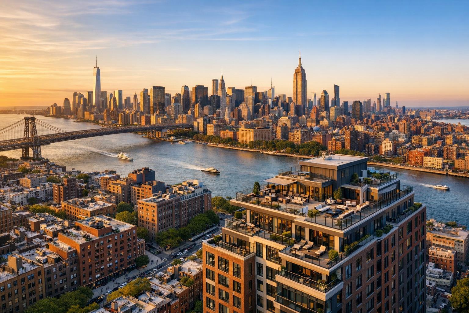
Drone photography captures a stunning view of NYC's skyline and waterfront at sunset, showcasing iconic skyscrapers and the bustling cityscape.
Drone Photography NYC: How Aerial Imagery Is Transforming Real Estate Marketing in NY & NJ
Introduction
Drone photography NYC isn’t just a trend—it’s fundamentally transforming real estate marketing NYC and beyond. In the fast-paced property markets of New York City and New Jersey, standing out means going beyond traditional visuals. In this article, you’ll learn how aerial real estate photography provides unique, compelling perspectives for listings, why professional compliance matters in urban airspace, and what it takes to capture the kind of media that drives results. Drawing from our extensive boots-on-the-ground experience photographing and filming everything from Brooklyn walk-ups to Jersey City condos, we’ll unpack the true impact of drone imagery—and guide you through best practices to maximize your property’s visual potential.
The Real-World Problem
Ask any agent, property manager, or host: consistent listing performance is tough to achieve in NYC and NJ’s oversaturated markets. Weak first impressions, flat low-angle phone shots, or dim, cluttered photography result in low click-through rates, poor engagement, and media that simply doesn’t reflect a space’s true potential.
The reality is, most listings—whether luxury penthouse or backyard rental—struggle with one (or more) of the following:
- No sense of place: Ground-level photos can’t show how a property relates to the block, skyline, water, or nearby amenities.
- Overlooked selling points: Even dramatic rooftop decks or private gardens get buried when photographed from the ground.
- Ill-defined scale: Without aerial context, buyers often can’t appreciate lot size, building prominence, or unique architectural features.
- Buyer hesitation: Basic or repetitive images fail to capture imagination—leaving buyers scrolling to the next option, especially in competitive rental or luxury segments.
- Inconsistent branding: Choppy, low-quality, or mismatched listing visuals erode trust and lower perceived value.
Clients regularly share how even well-staged interiors are let down by “cookie-cutter” exterior shots that fail to communicate value—especially with properties nestled among dense city blocks or in new developments. And skyline views or proximity to parks? Those are rarely conveyed well from street level alone.
What Experienced Media Teams Know
Great aerial real estate photography is never a matter of “just sending up a drone.” In urban environments like NYC and NJ, every shoot is a technical and creative challenge. Here’s what we’ve learned from years of shooting hundreds of buildings, homes, and complexes:
- Timing is everything: Golden hour shots can soften hard shadows cast by tall buildings and help exteriors pop, but scheduling must account for unpredictable weather, shifting light, and airspace limitations.
- Site logistics shape everything: Securing rooftop or terrace access in NYC often makes the difference between a breathtaking hero shot and a boring façade image. No two buildings are alike—each requires custom planning and coordination with property management.
- FAA compliance isn’t optional: All aerial shoots in NYC and NJ must be carried out by licensed pilots familiar with FAA Part 107 regulations. Urban airspace is layered with restrictions—professional teams pre-clear each project and secure the right permissions.
- Staging still matters: Aerials benefit from tidy outdoor spaces—vehicles cleared from driveways, debris removed from rooftops, and terrace furniture neatly arranged. These preparation steps are integral to our workflow.
- Framing for impact: We use high dynamic range (HDR) imaging and blue sky replacement when needed, ensuring listing visuals shine even on gray days. Every aerial angle is selected to enhance spatial context, highlight nearby amenities, and balance architectural lines for both accuracy and emotional pull.
- Turnaround is key: Delays kill listing momentum. Our production workflow is designed for rapid delivery—often within 24 hours—so agents and hosts can refresh their media and relaunch fast.
We’ve seen firsthand how buyers gravitate to listings with cinematic overviews—a dramatic sweep over the building, a sense of connection to the skyline, or a clear view of a property’s proximity to parks, rivers, or transport. Urban buyers in particular demand both detail and context, making quality drone imagery a must.
How RealtaSnap Solves It
At RealtaSnap, we built our aerial real estate photography program specifically for the unique challenges of NYC, New Jersey, and surrounding areas. Here’s how our approach sets listings apart:
- Process-driven Planning: Every shoot starts with a custom logistical assessment—evaluating building access, airspace restrictions, and the best windows for natural light.
- Expert, Licensed Pilots: Our drone operators are fully certified under FAA Part 107 and have deep experience navigating New York and NJ’s densely regulated skies. We always prioritize safety, compliance, and client peace of mind.
- Professional Coordination: We coordinate directly with building management and site stakeholders to secure the best possible vantage points. In dense areas, we always recommend securing rooftop access for the optimal shot.
- High-Quality Editing: We deliver fully retouched, color-balanced, and HDR-optimized aerials. Blue sky replacements, object removal, and custom branding are available according to your listing needs.
- Consistent Speed & Delivery: Most aerial media is delivered within 24-48 hours, with rush options available as market demands. No uncertainty, no waiting for a freelance vendor to get back to you.
- Easy Booking, Reliable Service: Everything from booking to file delivery happens through our streamlined online process. Agents, managers, and hosts control every detail—from adding special entry instructions to ordering last-minute add-ons right from their client portal.
Explore our dedicated drone photography and videography page for more details on how we serve NYC, NJ, and nearby markets.
Benefits of Choosing RealtaSnap
- Fully licensed, insured aerial operations for peace of mind
- Rapid delivery—media typically ready within 24–48 hours
- HDR and blue sky retouching included as needed
- Photos and video offered as stand-alone or bundled packages
- Strict compliance with urban drone regulations
- Real-world staging advice and prep checklists
- Custom access coordination for hard-to-reach sites
- Seamless online ordering and client dashboard
- Consistent visual branding across all your listings
- Pricing transparency with no hidden fees (see our service rates below)
Why This Matters in the NYC / NJ Market
NYC and New Jersey aren’t typical real estate markets; complexity and competition define them. Multi-family walk-ups, skyscrapers, historic brownstones, and new high-rise condos all share crowded online space. Buyers expect a premium experience, whether they’re searching for a Chelsea penthouse or a Hoboken duplex.
- Urban density: Aerials reveal what street-level shots can’t—showcasing open spaces, nearby transit, and distinct skyline views vital for positioning value.
- Buyers crave specificity: In markets flooded with similar listings, seeing a home’s connections to community features or green space can be a decision-maker.
- Platforms prioritize quality visuals: Sites like Zillow, StreetEasy, and Realtor.com boost listings with high-impact imagery, directly influencing visibility and engagement.
- Many listings compete on amenities: Pools, courtyards, gyms, and parks are often difficult to distinguish from interior angles alone—aerials bring these features to the foreground.
NYC and NJ buyers—whether investors, families, or first-timers—are visually driven and expect accuracy. Delivering this means partnering with professionals who understand local realities, restrictions, and what actually appeals to an urban audience.
Comparison with Traditional or Lower-Quality Alternatives
Choosing low-cost, rushed, or DIY media often leads to:
- Flat, uninspiring phone shots that “shrink” exteriors and neglect outdoor potential
- Missed compliance issues—risking fines or canceled shoots in restricted areas
- Inaccurate representation of scale and context (hard for buyers to visualize “sense of place”)
- Delayed delivery timelines, stalling listing momentum
- Inconsistent editing or lack of branding cohesion across platforms
- Poorly staged or untidy outdoor spaces highlighted—hurting, not helping, first impressions
- No backup plan if weather delays a shoot or roof access falls through
In contrast, a service like RealtaSnap delivers planned, inspected, edited, and consistent results—focusing on the logistical, visual, and regulatory details often missed by generic or part-time providers.
Operational Tips & Best Practices for Maximum Impact
1. Plan for Access
If possible, arrange rooftop or terrace access ahead of time. These vantage points can be the difference between a dramatic hero shot and a limited ground-level image, especially for multi-unit or high-rise listings.
2. Schedule for Ideal Light
Golden hour (just after sunrise or before sunset) delivers softer shadows and richer color but requires careful timing—especially with dense city buildings casting unpredictable shadows.
3. Declutter Scene and Surroundings
Remove roof debris, clear cars from driveways, and tidy up patios before the shoot. For urban lots, removing signage, trash bins, or seasonal clutter helps drone images pop.
4. Know Airspace Rules
Not all locations are flyable without advance clearance. Trust experienced teams to handle FAA rules, but be proactive about sharing location details early—permits or permissions can add lead time.
5. Bundle Services for Cohesion
Ordering aerial, interior, and video together ensures consistency in lighting, style, and visual story—something buyers notice subconsciously.
Transparent Pricing for Drone Photography
- Drone Photo (10 HDR images, 1-hour shoot): $209
- Drone Video (1-min professionally edited 4K video): $229
- Drone Photo + Video Package: $299
All prices and information are subject to change. Information is deemed reliable but not guaranteed.
To see the full menu of options—including bundled packages and add-ons—visit our drone photography page.
Conclusion & Call to Action
Aerial real estate photography isn’t just about pretty views—it’s about connecting buyers with your property’s true value, context, and emotional impact. In New York City and New Jersey, a well-executed drone shoot is the visual differentiator that sets your listing apart.
Our experience shows: properties presented with compelling, compliant, and high-quality aerial imagery engage more viewers, drive higher inquiry rates, and build long-term trust with buyers. Don’t risk your reputation or momentum—partner with professionals who treat every listing like a flagship project.
Get the visual edge your NYC or NJ property deserves. Learn more or schedule your next shoot at www.realtasnap.com.
Frequently Asked Questions
1. What if my property is in a restricted or controlled airspace area in NYC?
Many NYC locations are under strict airspace regulations. RealtaSnap’s experienced, licensed drone pilots assess feasibility on a case-by-case basis, always ensuring full legal compliance. If extra clearance or specific permits are needed, we’ll provide guidance. You’ll only proceed if compliant aerials are possible—no last-minute surprises.
2. How fast can I get drone photos and video after the shoot?
Most drone media is delivered in 24–48 hours after the shoot, depending on weather and site complexity. If your project is time-sensitive, let us know—we offer expedited editing and rapid turnaround when needed. Your listing never waits on delayed or inconsistent vendors.
3. Do I need to clear outdoor spaces before aerial photography?
It’s highly recommended. Removing vehicles, debris, and small items helps ensure the aerials make your property shine. Our team will advise on prep, and we can handle light retouching if last-minute cleanup isn't possible. Your property’s first impression matters—and RealtaSnap ensures it’s the right one.