The Impact of Drone Photography on NYC Real Estate Marketing and Presentation
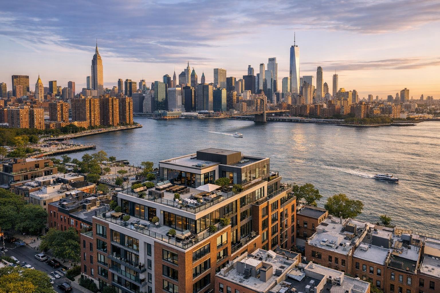
Drone photography showcases a stunning view of modern real estate with a city skyline and river in the background during sunset.
Drone Photography Real Estate: Transforming NYC Property Marketing with RealtaSnap
If you're trying to stand out in the New York City or New Jersey property market, drone photography real estate is no longer optional—it's essential. With more buyers starting their search online and platforms emphasizing striking visuals, real estate pros who harness aerial property photos and innovative tools like drone photography NYC are raising the bar for what a listing can accomplish. Below, you'll learn why drone photos make such a difference, how logistical challenges in these markets get managed, and how a real media team approaches property marketing for both residential and commercial spaces with practical, boots-on-the-ground savvy.
The Real-World Problem: Weak Listings Fall Flat in the NYC/NJ Market
Most agents, brokers, hosts, and sellers know the pain of listings that underperform online. Maybe you’ve experienced:
- Empty-feeling spaces that look smaller in photos than in person.
- Low click-through rates because the main image just isn’t compelling.
- Washed-out lighting, window glare, or crooked framing that plays down what’s great about your property.
- Indoor photos that fail to show a building’s scale, its relationship to the neighborhood, nearby parks, or a stunning skyline view.
- Lack of consistency across your portfolio, making branding and recognition a challenge for teams and high-volume agents.
This is especially true if your property is on a high floor, has a rooftop, or sits on a larger footprint—locations where traditional ground-based photography just can’t do the scenery justice. With so many listings vying for attention, those first few gallery thumbnails have to grab and hold the buyer’s eye, or you risk being overlooked.
What Experienced Media Teams Know
Real estate media professionals who specialize in drone photography real estate approach each shoot with lessons learned on dozens—sometimes hundreds—of rooftops, city blocks, and suburban lots:
- Lighting and Timing Matter: Drone shoots are often scheduled near sunrise or sunset (“golden hour”) to capture NYC’s iconic skyline bathed in warm, golden light, or to avoid harsh midday glare reflecting off glass towers. Knowing when building shadows will encroach on a lot line can make or break a shot.
- Preparation is Key: For aerial property photos to look clean and composed, a team will do a thorough pre-flight survey. We’re looking for clutter on rooftops, open construction, or nearby cranes that could be safety or aesthetic obstacles.
- Framing and Consistency: Framing the property to include views of Central Park, bridges, neighboring architectural highlights, or even river frontage takes knowledge of both drone piloting and visual storytelling. Professionals carefully adjust angles to present vertical lines straight (avoiding the common pitfall of slanted facades), and they blend aerials seamlessly with ground photography for a cohesive story.
- Turnaround and Workflow: Buyers move fast. Media teams have efficient workflows for capturing, editing, and delivering drone content (usually within 24-48 hours), so agents never miss a hot listing’s window of opportunity.
Teams who do this work in NYC and NJ also bring specific knowledge of airspace restrictions, roof access challenges, local permit requirements, and the real-world hassle of coordinating with doormen, supers, and condo boards. This is not a one-size-fits-all market.
How RealtaSnap Solves It
At RealtaSnap, we’ve built our entire approach around providing seamless, production-proof drone photography real estate services tailored for the unique demands of the NYC and New Jersey markets. Here’s how:
- Custom Flight Planning: Each mission starts with a review of local airspace, building access, and logistical constraints. We determine the feasibility—such as restricted FAA Part 107 zones or high-rise roof access—before confirming a booking, saving everyone time and avoiding last-minute disappointments.
- FAA-Compliant Crews: Our drone pilots operate fully within FAA guidelines and adapt to the city’s intricate airspace requirements—if a special permit is needed, we advise you up front rather than risking a cancellation or fine.
- Editorial-Grade Visuals: Using 4K and high-dynamic-range (HDR) cameras, RealtaSnap delivers aerial property photos and videos that show each listing’s true scale, highlight its position within the neighborhood, and capture dramatic skyline or waterfront views.
- Fast, Consistent Delivery: Thanks to efficient pre-production and in-house editing, we deliver finished files in as little as 24-48 hours. Our consistent color grading and vertical correction ensure your branding and property “feel” remains uniform across all listing media.
- Easy Booking, Transparent Pricing: Through our real-time online scheduling, you can select your services, see available slots, and confirm your shoot in minutes. Payment is taken up front, eliminating paperwork headaches and confirming your spot.
For more details or to schedule, visit www.realtasnap.com/drone-photography-videography-nyc.
Benefits of Choosing RealtaSnap
- FAA-compliant drone pilots with hands-on NYC/NJ expertise
- Same-day or next-day turnaround on drone media files
- HDR images with blue sky replacement for perfect conditions
- Cohesive aerial and ground photo packages
- Transparent, flat-rate pricing with no hidden fees
- Real-time online booking and instant scheduling confirmation
- Workflow designed for both single listings and teams/agencies
- Consistent editing for recognizable, professional branding
- Support for both residential and commercial marketing needs
- No municipal permit hassle—guidance on every project’s feasibility
Why This Matters in the NYC / NJ Market
In New York City and New Jersey, every listing is competing against not just others on the block, but architectural icons, luxury towers, and inventive new developments. Buyers (and renters) in these markets expect media that speaks to the city’s energy, scale, and aspirations.
- Diverse Property Types: Co-ops, condos, townhouses, rentals, commercial spaces, and mixed-use buildings all present different aerial challenges. RealtaSnap tailors each shoot for the property’s unique architecture and use-case.
- Crowded Skies, Tight Spaces: NYC is famous for its restrictive airspace, busy skylines, and patchwork of permit requirements. Navigating these smoothly takes local experience.
- Platform Behavior: Listings syndicated on Zillow, StreetEasy, Realtor.com, and Redfin get only one or two shots at a buyer’s glance—first images are critical for engagement. Unique drone images from an accurate perspective set your listing apart right away.
Comparison with Traditional or Lower-Quality Alternatives
- Smartphone or Amateur Drone Shots: These often result in overexposed skies, unbalanced windows, and awkward angles. Some lower-end service providers don’t correct for lens distortion, making buildings look warped or “tumbling.”
- Rushed Media Companies: Without deep experience, teams may miss the best times for lighting, overlook access issues, or deliver images that feel generic and misrepresent the property’s scale or setting.
- Delayed Turnaround: Waiting multiple days for drone edits means missed showings and slower e-mail responses from buyers.
- One-Off Providers: Inconsistent editing and delivery make it hard for teams to maintain recognizable branding and a professional online presence.
In contrast, RealtaSnap provides cohesive, fast, and visually striking content delivered by local pros who know the territory and genuinely care about your results.
Conclusion & Call to Action
Whether you’re marketing a Tribeca penthouse, a Jersey City high-rise, or a set of Brooklyn lofts, your listing deserves the impact that only drone photography real estate can deliver. RealtaSnap's veteran NYC/NJ media team brings local knowledge, regulatory savvy, and an obsessive commitment to visual quality—giving your property its moment to shine. Let your next listing make a powerful first impression.
See how easy it is to transform your listing with aerial imagery—explore our drone services and book instantly on our site, or find more about our full media offerings at www.realtasnap.com.
Frequently Asked Questions
1. What if my property is in a restricted or controlled airspace in NYC?
It’s a common concern—NYC’s airspace is among the most tightly regulated in the nation. RealtaSnap’s team evaluates every project for FAA compliance and always checks local restrictions before confirming a shoot. If extra municipal permits are needed, we’ll let you know upfront and help you explore alternatives or reschedule. You won’t encounter last-minute surprises or risk an unapproved flight.
2. How long does it take to receive my finished drone photos and videos?
Agents and property managers often worry about delays costing them valuable listing time. At RealtaSnap, drone content is usually delivered within 24–48 hours after the shoot, making sure you hit the market at just the right moment. Fast turnaround is built into our workflow, so your property never gets stuck in editing limbo.
3. Is drone photography only worth it for high-end or luxury listings?
This is a common misconception. While drone photography adds undeniable impact to luxury marketing, it’s just as valuable for rentals, condos, new developments, and commercial listings—any property that benefits from conveying scale, surroundings, and neighborhood context. RealtaSnap’s pricing is transparent and accessible, helping every listing stand out competitively.
All prices and information are subject to change. Information is deemed reliable but not guaranteed.