The Evolving Role of Drone Photography in NYC Real Estate Marketing
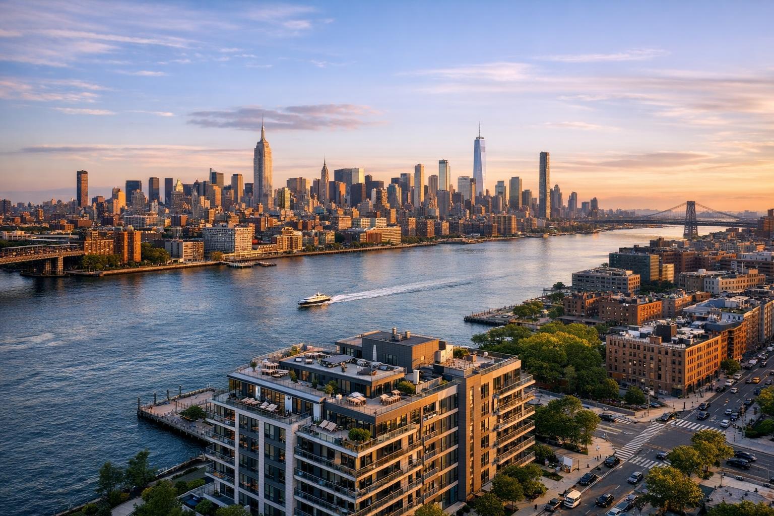
Drone photography captures a stunning aerial view of NYC's skyline at sunset, highlighting the waterways and iconic buildings.
Unlocking the Power of Drone Photography NYC for Real Estate Marketing
Drone photography NYC is redefining how real estate listings capture attention in today’s market, leveraging high-impact aerial real estate photography to help agents elevate property value, engage buyers faster, and stand out amid relentless urban competition. If you’re navigating the complexity of selling, leasing, or managing property in New York City or New Jersey, understanding how expert aerial visuals influence results—and choosing the right partner—can make all the difference. In this post, you’ll learn why drone photography for real estate is so effective, what sets a seasoned media team apart, how RealtaSnap delivers reliability and quality, and how strategic visuals change outcomes for local listings.
The Real-World Problem: Why Average Media Fails in NYC Real Estate
Agents, hosts, brokers, and sellers in NYC face a crowded, discerning marketplace where every listing is one click away from being skipped. Poorly lit, unevenly framed, or uninspired listing photos result in:
- Low click-through rates as listings blend into the endless scroll
- Weak first impressions due to flat, mundane imagery that fails to create emotional pull
- Media that doesn’t capture the property’s surroundings, context, or lifestyle value
- Underutilized roof decks, terraces, or shared amenities that never get their own moment
- Empty, lifeless interiors that strain buyer imagination—especially in vacant or staged condos
- Inconsistent branding or photography style across listings, creating a lack of trust
- Delayed buyer engagement, since generic or dated visuals seldom spark instant interest
In our experience, the hardest listings are often those with unique layouts, unusual orientations, or prime location bonuses unseen from street level. Without tailored visual solutions, even luxury properties can underperform—wasting days on market and missing their peak audience window.
What Experienced Media Teams Know
Having photographed hundreds of NYC, Jersey City, and Hoboken listings, our team knows that great property media is as much about process as equipment. For aerial real estate photography, here’s what seasoned professionals address:
- Timing and Lighting: Golden-hour flights create richer shadows and dramatic exteriors, but you also need flexibility for midday clarity if the listing’s orientation demands it. Pilots coordinate with on-site staff and weather to hit the right window.
- Preparation: A successful shoot involves clearing balconies, straightening patio furniture, and prepping rooftops so exteriors look inviting from every angle—a step too often skipped by vendors focused only on interiors.
- Framing and Context: Aerial shots should show not just the property, but also its proximity to parks, skyline views, transit, or local hotspots. We use precise altitudes and angles to avoid distortion and emphasize vertical lines for a clean, editorial finish.
- Workflow: Media pros know buyers decide quickly online; that’s why our typical workflow gets edited aerials into your inbox, ready for MLS and content schedules, sometimes within 24–48 hours.
- Visual Consistency: Our editing process includes sky swaps, vertical correction, and color balancing to ensure every shot—ground or aerial—fits your branding and meets buyer expectations on any major listing platform.
The difference isn’t just camera gear or drones—it’s attention to detail, real-time decision making on site, and a relentless focus on visuals that drive engagement.
How RealtaSnap Solves It: Reliable Drone Photography Real Estate Services
At RealtaSnap, we make drone photography for real estate seamless for NYC and New Jersey agents. Our in-house FAA-certified pilots manage every aspect of the aerial shoot, from creative planning to compliance—eliminating the “will they show up?” guesswork.
Operational details that make our workflow stand out:
- Direct-to-pro platform: Schedule your NYC or NJ drone shoot easily online, with instant confirmation and support.
- Pre-flight consults: We connect with you or your team ahead of time to review your shot list, identify space prep needs, and clarify local restrictions (NYC drone zones are tricky—we handle the paperwork).
- On-site efficiency: Pilots and photographers work together to capture all requested exteriors, roof decks, amenity spaces, and neighborhood context with both wide and detail shots, ensuring you have options for listing, marketing, and social media.
- Fast, consistent delivery: Most finished aerial real estate photography is delivered within 48 hours, professionally edited—ready for MLS, StreetEasy, or your marketing team.
Pricing is straightforward and transparent. Drone photography for real estate in NYC or NJ starts at $275 per property, which includes flight time, creative direction, expert editing, and a full set of high-resolution MLS-ready images.
All prices and information are subject to change. Information is deemed reliable but not guaranteed .
Ready to preview a typical booking, package, or area served? Visit the RealtaSnap services page to see current rates and media packages.
Key Client Benefits
- FAA-certified pilots ensure maximum legal compliance and safety
- Strategic aerial composition highlights property features and location
- MLS-ready images turned around within 48 hours
- No hidden fees—transparent, all-inclusive drone package pricing
- Fast online booking with dedicated team support
- Fully edited images to match your brand
- Includes wide, detail, and context-driven shots
- Pre-flight consults customized to each listing and site
- Serves all major NYC boroughs, as well as New Jersey Gold Coast
Why This Matters in the NYC / NJ Market
New York’s real estate is unlike any other. Buyers expect a full, immersive sense of place—knowing not just the inside, but what’s on the block, which way the rooftop faces, and where those Hudson sunsets land. In Manhattan and Brooklyn, views and location can translate to six-figure swings in perceived value. For rental listings in Jersey City or Edgewater, showing proximity to transit or waterfront or recreating the “skyline effect” can move your listing to the top tier.
Urban markets demand aerial real estate photography that captures density, vibrancy, and space—communicating qualities a ground-level phone snap can’t. In New Jersey’s suburbs, context is just as vital, revealing yard sizes, neighborhood charm, or privacy from a bird’s-eye perspective. Listing platforms and luxury buyers alike now treat professional media as table stakes—the right visual can make your offering stand out, even for highly competitive mid-tier rentals or sales.
Comparison With Traditional or Lower-Quality Alternatives
Choosing average or inconsistent real estate media means risking:
- Phone photos: Limited angles, poor consistency, and lighting issues—especially for exteriors and high floors.
- Rushed sessions: Inadequate room prep, unbalanced exposures, or missed amenities like roof decks.
- Slow media delivery: Lost momentum as your listings wait for edited photos, leaving buyers and sellers frustrated.
- Inconsistent editing: Disjointed gallery style, color mismatches, or visible distortion, all of which signal unprofessionalism to viewers.
- Generic visual providers: Mass-market solutions who may not understand NYC drone restrictions or the demands of co-op/condo boards.
With RealtaSnap, every step—from booking to delivery—is tailored to the realities of New York and New Jersey real estate. We manage prep, compliance, timing, and editing so your property stands out visually and meets listing requirements every time.
Conclusion & Call to Action
Innovative agents and property pros recognize that drone photography NYC isn’t just a trend—it’s a proven way to create standout listings, draw buyers in, and market every unique aspect of your property. RealtaSnap brings years of experience creating media that works for this market—combining qualified pilots, creative direction, and rapid, reliable delivery to help you put your property’s best face forward.
To learn more about our aerial real estate photography packages, or to schedule your next NYC or New Jersey shoot, visit our RealtaSnap homepage or explore our current services and pricing. If you’re ready for elevated media and a smoother process, we’re ready to help.
Frequently Asked Questions
1. Is drone photography allowed everywhere in NYC and New Jersey?
Due to strict airspace regulations, certain NYC locations (especially in Manhattan) may have permit or flight zone restrictions. RealtaSnap’s FAA-certified pilots assess every address, handle compliance, and work with local authorities when needed, so you never have to worry about legal or safety risks.
2. How quickly will I receive my drone images after the shoot?
Most drone photography for real estate is edited and delivered within 48 hours of the session. Our workflow emphasizes speed without sacrificing quality, so you can launch your listing or marketing campaign right on schedule.
3. What’s included in the RealtaSnap drone photography package price?
Our base price covers all drone flight logistics, location scouting, on-site creative guidance, expert editing, and a set of MLS-ready, high-resolution images. There are no surprise charges—just transparent service that fits busy NYC and NJ listing needs.