How to Choose Drone Photography Near You for a Real Estate Listing
Drone photography showcases a luxurious lakeside home with a large pool surrounded by lush greenery and a serene waterway.
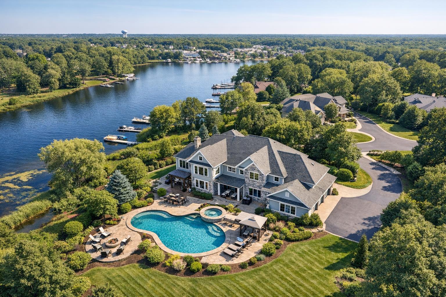
How to Choose Drone Photography Near You for a Real Estate Listing
Searching for drone photography near me means you’re looking for more than a close-by provider—you want to know whether aerial real estate photography can actually help market your listing, and whether a local team is prepared to handle the specific needs, challenges, and nuances of your property. The choice isn’t just about who’s closest; it’s about who can make sense of your location, visibility, airspace, and what will actually benefit your presentation.
Aerial photo and video are increasingly important tools for real estate professionals in places like NYC, New Jersey, and their unique neighborhoods. But not every property—or every provider—is a good match for drone media. We see this every week in our work at RealtaSnap, and over time certain selection patterns and practical factors stand out.
Why Use Aerial Real Estate Photography for Your Listing?
Drone imagery is valuable when it reveals something about the property that ground-level photography simply can’t. The goal isn’t to get a camera up high for the sake of it, but to answer visual questions that buyers, tenants, or investors might have:
- What’s the true size or shape of the lot?
- How does the home or building sit relative to surrounding features—water, parks, roads, amenities?
- Can viewers see driveways, access points, parking, or relationship to the street?
- Where does a commercial property begin or end—and how is it accessed or positioned?
For a Manhattan condo, you might want to highlight roof access, nearby green space, or rooftop amenities. In suburban New Jersey, it could be about showing a well-landscaped yard, pool, or extra buildings. Waterfront homes often need aerial angles to capture the proximity and access to the water—details that might not be obvious from ground shots alone.
Ask yourself: What will someone understand from this drone image that they can’t get from ordinary listing photos?
When Does Drone Coverage Make Sense?
Drone photography for real estate is not a routine add-on for every listing. In fact, it’s most effective—and worth the investment—when specific exterior qualities or site context matter.
Good candidates often include:
- Detached homes with spacious or unique outdoor areas: Pools, patios, gardens, decks, or a winding driveway can look much more appealing and clear from above.
- Waterfront and shore properties: The value is in the setting. Aerial images show how the property relates to docks, beaches, bulkheads, or scenic views.
- NYC brownstones and city buildings (with caveats): Details like roof terraces, rear gardens, or proximity to a park sometimes benefit from drone coverage, but dense buildings, limited space, and restricted airspace make feasibility uncertain. Local context, building rules, and safety always come first.
- Commercial properties and development sites: Aerial context helps clarify parking, loading areas, neighboring infrastructure, and the scale of the site. It’s also useful for showing a property’s role in a larger commercial area or as documentation before development.
Drone isn’t automatically helpful for every space. It’s less likely to add substantial value for apartments with no exterior features, single-family homes on small lots, or sites where dense surroundings obscure useful views.
Drone Photo, Video, or Both?
The format you choose should reflect how you plan to use your aerial media.
- Photo only: Ideal for listing galleries, brochures, websites, or detailed offering packages. Still photos are easy to review and often all that’s needed for clarity. At RealtaSnap, our standard drone photo service delivers 10 HDR images with blue-sky replacement if the weather doesn’t cooperate.
- Video only: Best when movement helps, such as showing approach routes, flyovers, or gradual reveals of scale—especially effective for commercial, waterfront, or high-end listings. Our drone video service provides a final 1-minute 4K edit.
- Photo and video: The most flexible approach if you want images for the listing and video for property reels, teasers, or to add context to a full on-site listing video. The combined package includes 10 HDR photos and a 1-minute 4K video.
As of this writing, you can expect $209 for photos, $229 for video, or $299 for both. Always confirm current pricing before booking.
Not All Nearby Providers Are Equal: Practical Evaluation Matters
Just finding a provider “near me” doesn’t mean a flight is a guarantee. Drone operations are subject to strict FAA Part 107 rules, local and federal airspace restrictions, safety considerations, and weather. What looks easy from a satellite map can become unworkable in the field.
A professional will evaluate each listing address individually—never promise flights without:
- Assessing for controlled, restricted, or sensitive airspace (especially in NYC)
- Determining if FAA authorization is required and, if so, handling the request properly
- Confirming takeoff/landing options, roof access (for urban sites)
- Reviewing the presence of airports, heliports, major infrastructure, or pop-up event restrictions
- Checking on vehicle/pedestrian activity and the safety of people and property nearby
- Reviewing weather, precipitation, and wind for safety and quality
- Explaining rescheduling or no-go policies for any unsafe or non-compliant conditions
- Clarifying building management or owner permissions (for roof or restricted access)
Occasionally, the most compelling and compliant aerial angle starts from an available roof rather than a crowded sidewalk or street. While this may unlock unique views, it’s still subject to regulatory limits and practical realities.
What to Look for in a Drone Photography Provider
Choosing the right drone media partner goes beyond picking the closest name on a map. Realtors, brokers, and property owners should review a provider’s actual experience with real estate, not just pretty aerial shots.
What matters most:
- Relevant real estate work: A quality portfolio should include detached homes, city brownstones, commercial blocks, and unique sites—not just rural land or generic scenery.
- Clear compliance and safety approach: They should explain that each property is evaluated individually and provide a transparent workflow for approvals and risk. Be wary of “guaranteed coverage” providers who don’t ask about airspace or access.
- Deliverables that match your plan: Confirm the exact number of images, HDR status, video length and delivery, blue-sky replacement, and usage rights.
When possible, coordinate interior and drone capture—visual consistency improves the overall listing story. Ground-level images show rooms and finishes, but drone images clarify site and context.
How to Prepare the Property for a Drone Shoot
Aerial photos don’t hide much from overhead, so a little exterior prep goes a long way. Before the shoot:
- Move vehicles from driveways and visible parking areas
- Store away trash bins, hoses, tools, or loose outdoor gear
- Arrange patio furniture and pool areas thoughtfully
- Confirm necessary gates, roof access, or outdoor access are unlocked or available
- Notify occupants or managers about timing if required
- Identify critical features or amenities you want shown
- Share any unique access instructions or restrictions before booking
For commercial listings, be mindful of high-traffic times or large deliveries. For waterfront homes, prepare docks, boats, and landscaping as you would for any high-quality listing photo shoot.
Working With RealtaSnap for NYC and New Jersey Aerial Media
RealtaSnap provides on-site drone photography and video services throughout New York City and New Jersey. Every drone project is evaluated case by case, using the precise address, airspace classification, weather forecasts, access options, and—importantly—the pilot’s discretion for safety and appropriateness. We never guarantee flights in dense areas or restricted airspace, and won’t promise what conditions or regulations won’t allow.
Bookings happen online. Select your service, enter the property address, add any access notes or special priorities, and choose the available appointment time that suits your schedule. Our system allows for bookings with 24 hours' notice, and all payment is handled at checkout. See all RealtaSnap services, online booking, and other info at www.RealtaSnap.com.
Bringing Exterior Context Into Your Listing Story
Aerial media should offer clarity—not just a new angle. The best drone photos and video highlight what makes a listing special from the outside, whether that’s land, views, architecture, amenities, or site placement. Picking a thoughtful local provider and preparing for operational realities will help you capture and communicate those strengths with confidence.
If you’re deciding whether aerial real estate photography is the right fit for your next NYC or New Jersey listing, RealtaSnap can help you evaluate the options. Read more or schedule your next shoot at www.RealtaSnap.com.
FAQ
Question: Can I always add drone photos to my Manhattan or Brooklyn listing?
Answer: Not always. Dense urban areas require case-by-case evaluation for airspace, roof access, access permissions, and safety. The property address must be reviewed to see if a legal and safe flight is possible.
Question: What if my property doesn’t have a big yard or open space?
Answer: Drone imagery can still be useful if you want to highlight roof decks, terraces, park proximity, notable architecture, or the building’s context within a block or neighborhood. If exterior context isn’t a selling point, professionally captured ground-level images are usually enough.
Question: How much notice do I need to schedule a drone shoot with RealtaSnap?
Answer: RealtaSnap’s online system allows scheduling with at least 24 hours’ notice. Make sure to include all access details and any priorities during booking to help us review and plan your aerial capture appropriately.