How to Choose Drone Photography Near Me for a Real Estate Listing
Drone photography near me captures an upscale suburban neighborhood with a lake, luxurious homes, and a variety of lush landscapes.
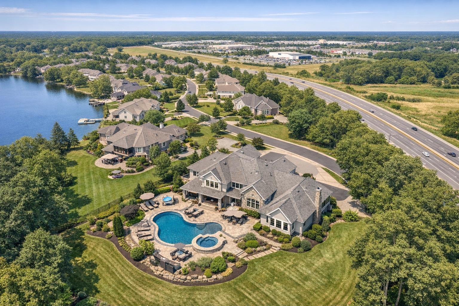
How to Choose Drone Photography Near Me for Your Real Estate Listing
Searching for drone photography near me often signals you have a listing that could truly benefit from an aerial view, but you’re wondering: Is drone media really the right call this time—and what do you need to know before booking? If you’re a real estate agent, owner, or property professional in NYC, New Jersey, or nearby areas, navigating that decision means blending visual practicality with local know-how.
What an Aerial Perspective Really Offers
The best reason to consider aerial real estate photography is to show buyers something they can’t see from the ground. A well-planned aerial image can orient viewers—helping them understand if that backyard is actually deep, how the home relates to its lot lines, where the closest park sits, or just how private the driveway feels. On larger lots or properties with outdoor features worth highlighting, the value is even greater.
Aerial photography is most useful for:
- Demonstrating the size, shape, and boundaries of land that can’t be captured from a sidewalk.
- Showing the relationship between a structure (home, building, commercial site) and its surroundings.
- Highlighting rooflines, architectural layouts, and outdoor amenities like pools, patios, or gardens.
- Revealing waterfront position, access to walking trails or beaches, or proximity to parks and golf courses.
- Providing location context—such as how an apartment complex sits among other neighborhood features or nearby business districts.
It’s not just about getting a higher shot. The key is making the aerial imagery answer real buyer questions: Where is this property? What’s next door? How do the exterior spaces connect?
For example, suburban New Jersey homes with big yards often shine in an overhead photo revealing both green space and useful structures, while a waterfront house might benefit from a lower, angled aerial showing both the house and the shoreline. In denser urban areas like Manhattan or Hoboken, practical flight and visibility options can shift, and creative framing becomes essential.
Where Drone Coverage Delivers the Most Value
Not every listing justifies aerial media. If you’re marketing a condo with no exterior highlights or minimal context, strong interiors, building amenities, or a detailed floor plan may be more valuable. But certain property types nearly always see a benefit:
- Larger residential homes: Aerials clarify the full footprint and let buyers understand usable yard, detached garages, or privacy features.
- Waterfront, shore, and creek- or lake-adjacent properties: Aerials provide essential context you can’t replicate from the curb or a map screenshot.
- Visually or architecturally interesting homes: Unique rooflines, estate grounds, or multi-level layouts are easier to appreciate from above.
- Multifamily, development, and commercial properties: Site layout, parking areas, and building placement are best explained visually from the sky.
In all cases, aerials should supplement—not replace—good ground-level photography. Eye-level images still provide critical details on approach, façade materials, and entry experience.
Photos, Video, or Both? Matching the Right Format to the Job
Deciding between aerial photos and video comes down to how you intend to present the property:
- Aerial Photos: Clean, high-resolution stills fit seamlessly into listing galleries, brochures, property websites, and social posts. Photos are ideal if you want to highlight exterior angles or supplement an already-strong suite of ground shots.
- Aerial Video: Video provides movement and flow—a gentle reveal of the home, a showcase of how exterior spaces connect, or a transition from the street to the property. Most effective when planned as part of a listing video, rather than as disconnected aerial-only clips.
- Both: Listings with substantial exterior appeal—think estate homes, waterfront properties, or commercial sites—often benefit from integrating both stills and video, giving maximum flexibility for presentation.
If you work with RealtaSnap, the options are straightforward: drone photo (10 professionally edited HDR images), drone video (one-minute 4K final video), or a combined package (both photo and video). Feasibility, however, always depends on the property location and local flight conditions.
Local Constraints: Airspace, Urban Blocks, and Real-World Feasibility
The most overlooked step in searching for real estate drone photography is simply confirming if a drone can actually be flown at your address. In New Jersey, many residential homes offer open airspace and easy outdoor access, but that’s not a universal rule. Controlled airspace, proximity to airports, or temporary safety restrictions may affect what’s possible at a given time.
In NYC, particularly in Manhattan, Brooklyn, and other dense areas, local buildings, crowded streets, and highly regulated airspace add extra layers. Sometimes rooftop access helps, but it never overrides FAA rules, building permits, weather, or the pilot’s professional assessment. Not every Manhattan, Queens, or Jersey City address will be flyable.
For any service provider—including RealtaSnap—all drone operations must follow FAA Part 107 rules and local safety standards. Weather, access, and authorization are non-negotiable, and special municipal or event permits (such as NYPD signoff) fall outside standard real estate coverage and are the client’s responsibility.
Core Questions to Ask Before Booking Aerial Media
Too often, proximity is weighed above capability. Before you book, focus your questions on the provider’s experience with real estate—especially listings like yours—and their grasp of what makes a property photograph well from above.
- Portfolio relevance: Review real examples that mirror your listing type—suburban homes, waterfront, multifamily, or commercial spaces. Do their aerials genuinely clarify the property, not just land or sky?
- Deliverables and use case: Be clear about what coverage you need and how you plan to use it. Are you adding stills to a listing gallery, creating a video trailer, or both? Providers should explain the differences in planning, composition, and post-production for each.
- Access and logistics: Share entry instructions early—rooftop access, building check-ins, yard prep, adjacent construction, or active areas all factor into what's possible on site. For homes, prepare exteriors just as thoroughly as interiors: move vehicles, tidy up, and remove distractions.
- Weather flexibility: Since aerial work is weather-dependent, ask about rescheduling procedures and buffer your timeline accordingly. Wind, rain, or poor visibility can easily shift a drone shoot.
RealtaSnap’s Approach to Aerial Real Estate Media
At RealtaSnap, drone photo and video services are available for listings in New York City, New Jersey, and select locations in Westchester or Upstate New York (case by case). Each property address and access situation is reviewed before confirming a drone shoot. The goal is always to create images with clear market value—presenting the property’s setting, scale, or unique layout in ways that ground photos alone can’t match.
Drone coverage can be booked directly online. Simply enter the property address, include relevant entry and access notes, select your preferred aerial package, and choose from available appointment dates. At least 24 hours’ notice is necessary, with payment handled at checkout. If you need to review option details, you can find more information about aerial and other services on the RealtaSnap homepage.
Making Drone Media Work for Your Listing
Aerial images are most effective when chosen on purpose: to visualize setting, disclose lot details, or reveal exterior features buyers actually care about, not just because the technology exists. If the listing’s key selling points are about view, scale, or neighborhood context, high-quality drone media will stand out. Otherwise, focus on media that communicates what’s truly important for your property.
To get the best results, identify the most compelling exterior elements, prep the site in advance, and communicate your intentions clearly when booking. Making aerial media serve the property—not the other way around—will yield the most useful, market-ready assets.
If you have a new listing in NYC, New Jersey, or the nearby service area, RealtaSnap is happy to review the address, discuss feasibility, and recommend the best media mix for your needs. Learn more or start your booking at www.RealtaSnap.com.
FAQ
Question: How much does RealtaSnap drone photography cost?
Answer: Drone photo packages are $209 for 10 professionally edited HDR images (with blue sky replacement if needed). Drone video is $229 for a one-minute final 4K video. The combined package, which includes both, is $299. All drone sessions remain subject to location-specific flight feasibility and safety review.
Question: Can you fly a drone for a Manhattan or Brooklyn real estate listing?
Answer: Sometimes—but it depends entirely on the address, airspace, site access, weather, and applicable restrictions. Some city properties may not be flyable due to FAA airspace rules or practical limitations. Always confirm feasibility before assuming drone coverage is available.
Question: Should every real estate listing use drone photography?
Answer: Not necessarily. Drone media is most effective for listings with notable exterior features, land size, waterfront location, or unique setting/context. For typical small apartments or condos without meaningful exterior context, it’s often better to focus on great interior photography, building features, and well-presented listing details.