How to Choose Drone Photography Near Me for a Real Estate Listing
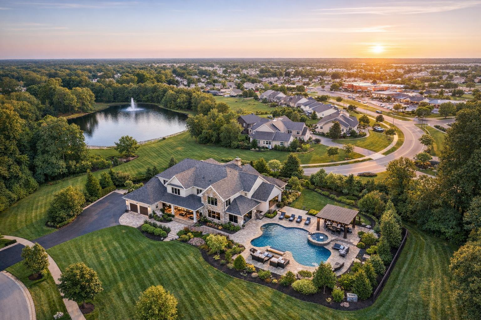
Drone photography captures an aerial view of a luxurious house with a landscaped backyard, pool, and nearby lake at sunset.
How to Choose Drone Photography Near Me for a Real Estate Listing
Searching for drone photography near me usually means your listing has a story to tell from above—and you want to know if aerial media will truly help you tell it. We see this question often from agents and marketers who want to make smart decisions, rather than just adding drone shots for the sake of novelty. The right aerial perspective can reveal a property’s context, show off land, water, outdoor amenities, architecture, or location features that ground-level images struggle to capture. It’s a powerful tool, but not always the right one for every listing.
In this edition, our RealtaSnap team shares what actually matters when deciding if real estate drone photography services are worth considering for your NYC or New Jersey listing. We’ll cover practical decision points, operational realities, and the questions professionals ask themselves before booking.
When Does Aerial Real Estate Photography Actually Make Sense?
It’s tempting to think of drone photos as a default visual upgrade, but real estate media benefits from purpose-driven choices. Aerial shots work best when they help the next viewer—whether that’s a buyer, tenant, or investor—see something they wouldn’t otherwise understand.
Drone photography is most useful when:
- The property sits on a larger or unusually shaped lot, or has clear boundaries.
- There is waterfront access, sweeping views, or proximity to water (shorelines, marinas, rivers, lakes).
- Outdoor amenities like a pool, sports courts, extensive landscaping, gardens, or outdoor kitchens play a major role.
- Architecture is dramatic from above: modern rooflines, enclosed courtyards, unique terraces.
- Nearby parks, green spaces, trails, or golf courses are key selling points.
- Access to main roads, transportation, or commercial hubs shapes the property’s appeal.
- The property is a commercial site, multifamily building, or warehouse campus where scale and configuration matter.
- Rooftop areas or upper terraces offer meaningful views or setting context.
Contrast that with a compact townhouse or condo with minimal outdoor space: unless there’s an exceptional setting, aerial imagery often adds little and can even dilute the listing’s narrative. Not every listing earns its moment in the sky.
What Aerial Media Can Capture That Ground Photos Can’t
Ground-level images are foundational for any listing—front façades, walkways, landscaping, and curb appeal are best told from eye level. Drones add dimension and context, not just drama. Here’s how aerial real estate photography adds value when it’s thoughtfully aligned with property strengths:
- Lot Layout and Boundaries: Overhead views clarify how a house is positioned on its land, showing driveways, detached structures, or unique lot shapes that are hard to explain from the ground.
- Outdoor Flow and Amenities: An aerial angle can connect the dots between patios, pools, lawns, and gardens, showing how these spaces integrate into actual living or entertaining areas.
- Waterfront and View Proximity: For shore homes or properties near water, the way a property relates to beach, bay, or marina is visually clear from above. The view isn’t just a feature; it’s context.
- Architectural Form and Rooflines: Contemporary designs, building footprints, and larger structures sometimes look their best from above, especially when roof decks or terraces are core features.
- Surroundings That Shape Value: In neighborhoods where proximity to parks, business districts, or transportation matters, an aerial image can clarify location far better than a simple street-level shot.
Not every aerial is valuable by default. Experienced teams ask: does this angle clarify a real feature, or is it just decorative?
NYC vs. New Jersey: Local Realities Matter
Drone media decisions are highly local, especially in the NYC and North Jersey region. In New Jersey, drone flights are often feasible where properties have larger lots, outdoor amenities, and fewer overhead constraints. Suburban or shore properties provide ample space for safe flying and creative coverage.
NYC, on the other hand, comes with its own set of complications. Manhattan and Brooklyn listings are tightly packed, with overhead obstacles, pedestrian activity, controlled airspace, and unpredictable construction zones. Safe takeoff and landing areas are limited. In many situations, roof access is needed just to attempt a flight—but having a roof doesn’t guarantee a drone operation will be allowed, safe, or productive. Each address needs fresh review.
That means every request for aerial coverage in NYC starts with negotiation: is it flyable, permitted, and safe? Sometimes, traditional photography, video, or even a well-composed window view is the more practical way to present the property.
Smart Questions to Ask Before Booking Drone Coverage
A professional approach always begins with understanding what the client hopes to accomplish with drone media. Before booking, we recommend working through a few essential questions:
- What’s the goal of the drone shots? Do you want to show lot size, a pool area, unique setting, distance to water, building scale, or just add “wow” factor? Be concrete.
- Is the property likely flyable? This comes down to location, room for drone flight, and airspace rules. Tightly built areas, no outdoor space, dense street traffic, or critical airspace can make flights impossible or impractical.
- Where will the drone take off and land? Safe operation is non-negotiable. Suburban yards usually offer room; city rooftops may require coordination with building management. Busy public areas, overhead wires, or high-foot-traffic streets can quickly rule out an aerial plan.
- What if weather changes? Wind, rain, or poor visibility ground all but the best drones. Flexibility in scheduling gives you the best chance at capturing both property and light at their peak.
- Are permits or special permissions required? FAA rules determine where drones can legally fly, and some locations require additional municipal or building approvals. RealtaSnap does not obtain special event or municipal permits; clients are responsible for checking whether their address requires these permissions.
Still Images, Aerial Video, or Both?
Both can be effective for different reasons:
- Drone stills are perfect for online galleries and highlight reels, giving a crisp sense of setting or layout.
- Aerial video adds a sense of motion and reveals how a property relates dynamically to its surroundings. For example, a slow flyover from water to pool to rooftop can clarify flow in a way still images can’t.
For most listings, a handful of focused, meaningful aerials is better than a large folder of redundant overheads. The best drone media contextually supports interior and exterior photography, not replaces it. And when it comes to video: listing videos require on-site capture; simply stringing together photo slideshows isn’t the same as real flyover video.
Preparing a Property for a Drone Session
Prepping for drone work extends beyond decluttering a living room. Given the focus is on exteriors, here are some practical prep steps:
- Move cars from driveways and clear parking areas.
- Put away trash cans, hoses, and other yard clutter.
- Tidy up patios, pool decks, and outdoor furniture.
- Uncover pools and neatly arrange outdoor seating (if relevant).
- Freshen landscaping if possible: trim grass, tidy beds, remove fallen branches.
- Confirm all outdoor areas, rooftops, or gates are accessible.
- Inform on-site contacts or residents about the scheduled aerial work.
The aim isn’t to present the property as flawless or artificially perfect, but to remove distractions so the land, architecture, and features can be captured cleanly.
Choosing a Local Provider for Real Estate Drone Photography Services
Not every company offering drone services is the right fit for real estate marketing. Some may focus on events, inspections, or construction. For optimal listing results, look for a local provider who:
- Understands the value of context and when it supports (or distracts from) the main story.
- Can explain how aerials complement, not overwhelm, the rest of your property media.
- Follows all relevant FAA, safety, and site-specific rules—including knowing when a property simply isn't realistically flyable.
- Has experience working in the complex environments of NYC and New Jersey—whether that’s a Jersey Shore home or a Brooklyn brownstone.
- Frames each property honestly, without distorting its relationship to amenities or presenting an unrealistic sense of privacy.
At RealtaSnap, aerial projects are evaluated on a per-listing, per-location basis. We handle drone work based on actual address, access, safety, airspace, weather, and pilot judgment. And if a location isn’t right for flight, we’ll say so upfront.
If you’re considering aerial coverage, you can learn more about our drone media options for NYC and New Jersey at our drone photography and video page, or explore recent work examples on our website.
Let the Property Lead the Plan
At the end of the day, drone photography is a strong tool when it adds real value to your property’s presentation—whether that means showing off a backyard oasis, mapping out a commercial site, or placing a waterfront home in context. But for many listings, strong ground-level photography remains the most effective (and often budget-wise) visual story.
If you’d like an honest assessment about whether aerial media is right for your NYC or New Jersey listing, or want to explore booking, you can schedule online at www.RealtaSnap.com. We handle each property as a unique case and are happy to provide guidance, not just generic options.
FAQ
Question: When is drone photography NOT necessary for a real estate listing?
Answer: Drone photography typically isn’t necessary for smaller urban apartments, condos without meaningful outdoor space, or any property where the aerial view would add clutter rather than clarity. Standard ground-level photography tells a better story in these cases.
Question: Can I book a drone session online, or do I need to call?
Answer: You can book drone coverage online at www.RealtaSnap.com/schedule. Just enter your property address, select your services, and choose an appointment. All drone sessions are confirmed on a case-by-case basis depending on location and feasibility.
Question: What makes drone flights in Manhattan or Brooklyn more complicated?
Answer: Dense city environments come with extra considerations: restricted airspace, buildings and overhead obstacles, tight lot lines, unpredictable foot traffic, and sometimes the need for building-specific access or special permits. Each property is reviewed for safety, legality, and practicality before confirming any drone media project.