How Drone Photography Elevates NYC Real Estate Listings
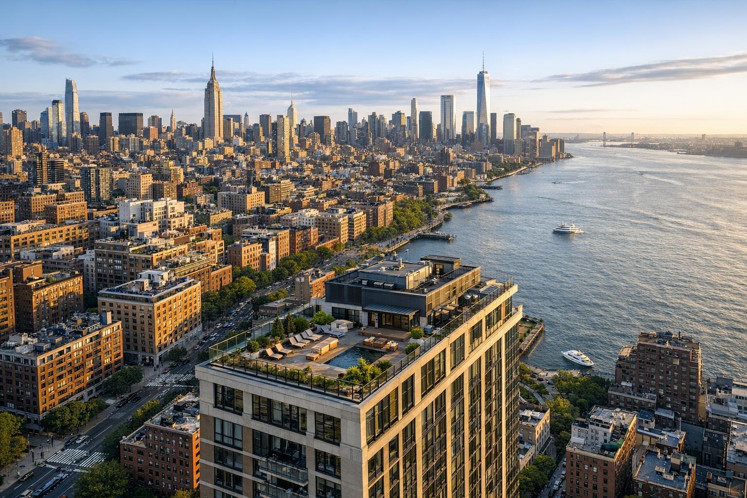
Drone photography NYC captures a stunning skyline view at sunset, featuring the Hudson River and iconic skyscrapers.
How Drone Photography NYC Changes Real Estate Listings
Drone photography in NYC gives real estate professionals and property owners a way to show listings that just isn’t possible from ground level. We see time after time that aerial images accomplish something different, putting the property’s position, exterior features, and neighborhood in clear context. For agents and owners who want more than an interior tour, aerial real estate photography can often tell the property’s story with a single shot.
If you manage listings in Manhattan, Brooklyn, Queens, or across the Hudson in New Jersey, you know how tough it can be to “explain” curb appeal, outdoor amenities, or location in a crowded urban environment. A carefully chosen aerial angle can bridge that gap, making features visible that would otherwise get lost in a tight photo gallery.
Let’s dig into what makes drone photography for real estate special, which properties tend to benefit, and what agents, brokers, and sellers should know about making the most of this tool.
What You See from Above: The Value of an Aerial Perspective
Interior photography is about finishes, flow, and light. Good exterior photography captures curb appeal and entry, but both can hit their limits—especially when the property’s main selling points are its location, usable outdoor space, or setting.
Aerial real estate photography answers spatial questions that ground shots can’t, such as:
- Does the property have a private terrace, backyard, roof deck, or courtyard?
- Where does the building sit on its block—corner, mid-block, set back, or waterfront?
- How does the property relate to parks, bridges, greenways, or commercial corridors nearby?
- Is there a meaningful view, walkable amenity, or expansive lot that is part of the listing’s appeal?
- Do exterior amenities like pools, patios, parking, or gardens deserve a visual highlight?
Aerials don’t replace interiors or regular exteriors. They show context: how a building fits with its surroundings, where outdoor spaces actually sit, and sometimes even “hidden” features like rooftop amenities that don’t show up well from the street. The best drone photos directly respond to a real question a buyer or renter might have: “Where is the terrace in relation to the skyline?” “How private is the backyard?” “What’s across the street?” If the image delivers that answer, it’s doing its job.
The NYC Reality: Not Every Listing or Every Address Is Drone-Ready
New York City is perhaps the most compelling—and challenging—market for drone photography real estate work. Dense development, close airports, no-fly zones, local restrictions, and safety requirements mean that launching a drone is never automatic. Even across the river in New Jersey, you’ll find fewer restrictions but similar considerations for airspace, proximity to busy areas, and site access.
Access to a rooftop or terrace can mean the difference between a feasible flight and a non-starter, especially in high-rise settings. FAA Part 107 compliance is a must; airspace and local permission need to be confirmed before anybody plans a shot. Sometimes, weather or a simple lack of exterior space makes a drone session impractical.
A key takeaway from working in and around NYC: talk about aerial options early, especially for buildings near airports, busy event venues, or in dense parts of Manhattan and Brooklyn. Be realistic with feasibility. Roof or terrace access often unlocks the most useful views and allows for safer operations.
Which Listings Benefit Most from Aerial Real Estate Photography?
Drone media is a strong fit for listings where location and exterior space are more than “nice to have.” Some property types that often warrant a drone session:
- Townhouses, Brownstones, and Detached Homes
These buildings can have deep, private gardens, unique rear additions, or detached structures that simply don’t show up from street-level. An aerial image connects facade, footprints, and outdoor living areas. - Penthouses or Apartments with Private Outdoor Space
Drone photos place terraces and roof decks within the setting of the skyline or a waterfront view, rather than isolating them as a blank rectangle. This can help buyers get a sense of how the private area relates to both the unit and the larger city. - Waterfront or View-Oriented Properties
Listings along the East River, Hudson, or bayfront areas depend heavily on location. A drone can capture both the property and its relationship to water, parks, or greenways—which is difficult (or impossible) to communicate clearly from the ground. - Residential and Commercial Properties with Scale
Large sites, multifamily buildings, retail complexes, warehouses, or mixed-use structures benefit from aerial images that show overall scale, boundaries, and access points. These visuals help orient viewers far more comprehensively than maps or floor plans alone. - New Jersey Homes on Larger Parcels or With Amenities
Compared to NYC, New Jersey listings may have wider lots, larger yards, pool areas, or detached garages—all of which are better understood with a higher vantage point. The same aerial approach applies across the five boroughs and statewide in New Jersey, with limited coverage also available in Westchester and parts of Upstate New York.
Preparing for an Effective Aerial Session: What Real Estate Pros Should Know
A successful drone session comes down to planning and practicality. Here’s what experience has shown makes a difference:
- Coordinate Site Access Beforehand
If using a rooftop, private yard, or gated courtyard is essential for useful shots, arrange permissions in advance. Factor in building management rules, access to elevators, keys or lockboxes, and requirements for on-site escorts. - Clean Up Exterior Spaces
Photos work best when clutter is cleared from the frame. Garbage bins, hoses, temporary equipment, and parked cars can distract from the qualities that actually matter. For occupied properties, authenticity is more important than creating an artificially “perfect” scene, but a little practical tidying always pays off. - Consider Natural Light and Shadows
The time of day affects the final look. Morning and afternoon light can reveal or obscure facades and outdoor areas, and tall buildings often cast deep shadows. While an experienced operator will evaluate conditions, it’s helpful to identify the most important angles and spaces ahead of time. - Let the Property’s Story Guide the Coverage
Rather than “just getting some drone shots,” focus on the features that matter most to the listing. Maybe it’s a top-floor terrace, a deep rear garden, or a site boundary that only makes sense from above. More images aren’t always better—one well-composed view can have more impact than a half-dozen repetitive ones.
Photos, Video, or Both? Matching Media to Your Needs
Aerial media can be still, moving, or a combination. Each serves a specific role:
- Drone Photos
Ideal for listing galleries, marketing brochures, email blasts, and property websites. Still images let viewers study details—garden layouts, rooflines, nearby streets—at their own pace. - Drone Video
Adds motion and a sense of flow or approach. Video can help set a listing video’s opening scene or highlight a dramatic movement from street to front door for listings with signature exteriors or larger grounds.
At RealtaSnap, drone packages are straightforward. The 10-photo HDR package is $209, a one-minute 4K drone video is $229, or you can opt for both photo and video for $299. Standard editing includes blue-sky replacement where appropriate. You can see current options on the RealtaSnap drone services page.
Selecting a Professional: What to Ask and Expect
Getting a compelling aerial image involves more than just operating a drone. Real-world experience in NYC and NJ should include:
- FAA Part 107 certification for legal commercial flights
- Upfront site review for safety, access, and airspace compliance
- Proven experience capturing real estate, not just generic aerial scenery
- Understanding the difference between still-photo and video use cases
- Comfort with logistics for access to rooftops, courtyards, or terraces
- Flexibility around shifting weather or unexpected site conditions
- A marketing, not inspection-oriented, approach to media
A responsible provider doesn’t treat every property as flyable. Each location and shot is evaluated for feasibility and safety—the pilot has the final say.
Adding Drone Media to Your Listing: The Practical Process
In most cases, the smoothest workflow is to decide about aerials early, before the main shoot is scheduled. This gives time to coordinate site access and clarify priorities. At RealtaSnap, clients can book a shoot online by entering their address, choosing the services, and adding notes about roof or exterior access if drone media is desired. The calendar shows real-time availability, and payment is due at confirmation. Standard bookings require at least 24 hours’ notice.
By planning ahead, you ensure that drone coverage is truly tailored to the property—rather than simply added on as an afterthought.
Context Is Everything: Why Aerials Work
Great aerial images give viewers answers they won’t get anywhere else. In a city defined by density, skyline silhouettes, and hidden outdoor gems—or in New Jersey neighborhoods with larger lots and open space—the way a listing is presented matters. For properties where context drives appeal, aerial real estate photography can help buyers, renters, and investors understand what makes a listing unique.
If you’re considering advanced media for an NYC or New Jersey property, you can find more information or book a session with RealtaSnap at www.RealtaSnap.com.
FAQ
Question: Are drone flights possible at every NYC or New Jersey address?
Answer: No, several factors affect feasibility: FAA rules, airspace class, local restrictions, pilot judgment, weather, safety on site, and access. Some locations may require special authorization, and not every property is drone-eligible.
Question: How soon can I schedule aerial photography with RealtaSnap?
Answer: Bookings are handled online. Once you enter the service address and select drone coverage, you’ll see open time slots on the calendar. Most sessions require at least 24 hours’ notice.
Question: What does drone photography cost with RealtaSnap?
Answer: Pricing is straightforward: 10 drone photos for $209, a 1-minute edited 4K drone video for $229, or a combined package of photos and video for $299. All options are subject to site feasibility and pilot discretion.