Expert Insights: The Impact of Drone Photography on New York City Real Estate Listings
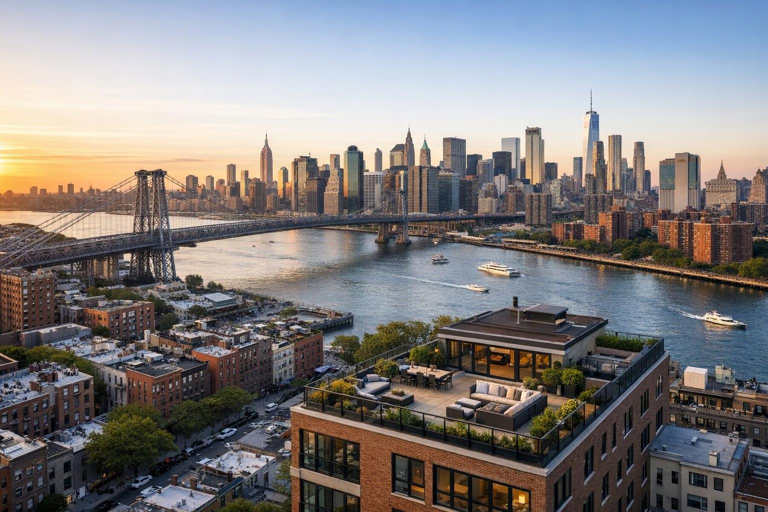
Drone photography captures a stunning view of city real estate with a rooftop terrace, a river, a bridge, and a skyline at sunset.
Introduction
Drone photography real estate is revolutionizing the way property listings catch attention in New York City and New Jersey’s fiercely competitive markets. From dazzling aerial real estate photography to immersive video flyovers, drone photography in NYC brings high-rise, brownstone, and suburban properties to life like never before. In this post, you’ll learn how aerial imagery gives NYC listings a true competitive edge, the unique visual storytelling only drones can provide, what it takes to deliver safe, legal, and high-quality drone shoots in the city, and why partnering with an experienced, local media expert like RealtaSnap sets your marketing apart.
The Real-World Problem
Real estate agents, brokers, and property managers across NYC understand the frustration of a listing that falls flat online. Maybe it’s a luxury condo that looks bland from street level, a multi-family property where buyers can’t appreciate the scale, or a brownstone that gets lost in a row of nearly identical façades. Common challenges include:
- Listings with weak first impressions and low click-through rates.
- Poor exterior photography that fails to communicate context, scale, or views.
- Empty rooftops, courtyards, and amenities that buyers can’t visualize from ground photos.
- Manhattan apartments that feel small and unremarkable, even when the rooftop views are spectacular.
- City or suburban homes with outdated curb shots that don’t show property boundaries or desirable surroundings.
In metropolitan NYC and New Jersey, buyers and renters search at record speed—scrolling through hundreds of listings where only the most eye-catching images inspire a pause. With growing competition from new developments, amenity-rich rentals, and luxury resales, classic ground-level photos often just can’t keep up.
What Experienced Media Teams Know
Teams who spend their days in the field—photographing listings, piloting drones, and working side-by-side with agents—see firsthand what works, what doesn’t, and why. Here’s what you’ll only learn from true production experience in the NYC-NJ market:
- Timing and Lighting: For aerial real estate photography, light can make or break an exterior shot. Harsh midday shadows distort rooflines and obscure detail, while late-day “golden hour” brings out architectural features, neighborhood character, and the allure of outdoor spaces.
- Framing and Perspective: The right drone angle reveals property scale, green spaces, skyline views, and roof amenities buyers want. Getting above the eye-line of passing foot traffic, taxis, and construction provides a clean, marketable angle you simply can’t achieve from the street.
- Compliance and Coordination: Flying drones in NYC isn’t like flying in the suburbs. It requires strict FAA Part 107 compliance, real-time airspace checks, assessment of building access for takeoff and landing, and careful coordination with on-site staff or building management. Not every location is “flyable,” and knowing in advance saves everyone time.
- Visual Storytelling: Great media isn’t just about technical skill. It’s about telling the listing’s story with visual authority—showcasing private terraces, capturing proximity to parks, revealing unique angles of a historic façade, and offering buyers a true sense of context in one glance.
- Workflow Details: Experienced teams plan for fast turnaround, manage window glare and reflection, account for weather unpredictability, and ensure each deliverable (photo, video, or virtual tour) feels like part of a consistent brand story—never a mix of mismatched, generic shots.
How RealtaSnap Solves It
RealtaSnap’s drone photography services are designed for New York City, New Jersey, and their surroundings—by people who actually photograph, edit, and deliver thousands of local listings each year. Here’s how RealtaSnap addresses your challenges with credible, hands-on expertise:
- Real-World Compliance: All flights are conducted by FAA Part 107-licensed pilots. We know the city’s restricted, controlled, and open airspaces—meaning each shoot is thoroughly vetted for legal and physical feasibility, and we coordinate with building management and onsite staff to ensure safe, compliant launches and landings.
- Aerial Media Tailored to Real Estate: Our drone imagery isn’t “one size fits all.” We capture 4K HDR photos and cinematic video flyovers, using practices developed for New York and New Jersey’s varied architecture—from luxury condos to historic townhouses, mixed-use buildings to suburban compounds.
- Consistent, High-Fidelity Visuals: Every drone shoot includes standardized blue sky replacement for overcast days, professional retouching, and meticulous attention to vertical/horizontal alignment. We plan shots to highlight building entryways, private rooftops, parking, and nearby amenities that drive buyer curiosity.
- Professional Workflow: Shoots are scheduled with just 24 hours’ notice (when available), with clear instructions for site prep and tenant/building coordination. Fast turnaround—delivering media ready for listing within a reliable window—means you’re never waiting for a deadline.
- Full Integration: Drone photography can be bundled with interior/exterior photography, video tours, and virtual staging for cohesive listing packages, all managed by a single, accountable team that knows the rhythm of the NYC/NJ market.
Drone services start at $209 for a 10-photo HDR aerial package or $229 for cinematic drone video, and $299 for combined photo/video bundles. All prices and information are subject to change. Information is deemed reliable but not guaranteed.
Learn more about professional drone services from RealtaSnap for your New York or New Jersey listings at www.realtasnap.com/drone-photography-videography-nyc.
Benefits of Choosing RealtaSnap
- FAA Part 107-licensed pilots familiar with NYC/NJ challenges.
- Turnkey scheduling and fast delivery for agents on tight timelines.
- HDR 4K aerial images with professional blue sky replacement.
- Visual storytelling crafted for real estate—not generic footage.
- Consistent color, vertical correction, and seamless integration with listing media.
- On-site shoot coordination with building staff and tenants.
- Simple, transparent pricing and no sales surprises.
- Flexible packages: photo, video, or combined aerial services.
- Reliable coverage across NYC’s five boroughs and all of New Jersey.
- One-stop project management for photos, drone, 3D tours, and more.
Why This Matters in the NYC / NJ Market
In NYC, every listing is vying for buyer attention in a hyper-dense, visually rich environment. Buyers expect to see not just interiors, but also context—private outdoor spaces, proximity to the skyline, distance to parks, and roof decks. With inventory moving fast and often unseen until the last minute, agents rely on media that instantly establishes credibility and entices action.
In New Jersey’s suburbs and rising urban centers, drone imagery differentiates a home by showcasing land, setting, and the “lifestyle” on offer—elements that matter in a market driven by schools, commutes, and neighborhood brand. Whether it’s highlighting a backyard pool or a city-view penthouse, compelling aerial views are the new expectation for top-tier listings.
Platforms like StreetEasy, Zillow, and MLS favor listings with professional, eye-catching media, and with mobile-first buyers scrolling in seconds, media quality now directly correlates to showing requests and perceived value.
Comparison with Traditional or Lower-Quality Alternatives
It’s tempting to settle for quick phone shots, amateur drone photos, or generic nationwide providers—but agents and managers quickly learn where that leads:
- Phone Photos: Lack of stability, weak dynamic range, and poor scaling for large or tall properties. Exteriors often miss architectural distinction or neighborhood context.
- Rushed or Inexperienced Shoots: Missed angles, unsightly roof clutter, distorted building lines, or inconsistent editing. Aerial media with poor framing or exposure issues can make properties look cheap instead of elegant.
- Inconsistent Editing: Color mismatches between ground and aerial shots, jarring transitions, and uneven sky exposure make listings look uncoordinated.
- Delayed Delivery: Slow photo or video turnaround means listings age on the market—leaving agents scrambling.
- Unreliable Coordination or Compliance: Missed flights due to lack of permitting or misunderstanding building access means disappointed sellers and wasted resources.
RealtaSnap’s integrated approach ensures your property is presented with the authority, efficiency, and local market understanding only an experienced, dedicated team can provide.
Conclusion & Call to Action
Investing in professional drone photography gives your listings a powerful, market-proven edge—especially in the high-stakes world of New York City and New Jersey real estate. With RealtaSnap, you benefit from hands-on expertise, a commitment to safety and compliance, and media created for the realities of the local market. Don’t let your listings get lost in a sea of sameness. Explore how RealtaSnap can elevate your marketing and help you capture buyers’ attention from the very first click. Ready to make a bigger impact with your next listing? Visit www.realtasnap.com and discover expert aerial real estate photography for NYC, NJ, and beyond.
Frequently Asked Questions
1. What if my property is in a restricted part of NYC?
Many areas in Manhattan and Brooklyn are subject to airspace restrictions. Our pilots always check FAA regulations and local conditions before flying. If a location is not flyable, we’ll notify you in advance and propose alternatives when possible. With our experience, you can trust your listing is always in safe hands.
2. How soon can I schedule a drone shoot and receive footage?
RealtaSnap offers next-day scheduling, pending availability, and delivers edited aerial images and videos quickly to support your listing timelines. You’ll never wait for weeks or risk losing momentum with buyers.
3. Do I need special permits or handle compliance paperwork myself?
We handle FAA compliance and standard airspace authorization but do not file for municipal or event-specific drone permits. If your project requires city permits, we’ll advise you right away and guide you through the process. Most listings do not require extra permits, and we keep the process simple and hassle-free.