Evaluating the Impact of Drone Photography on NYC Real Estate Listings
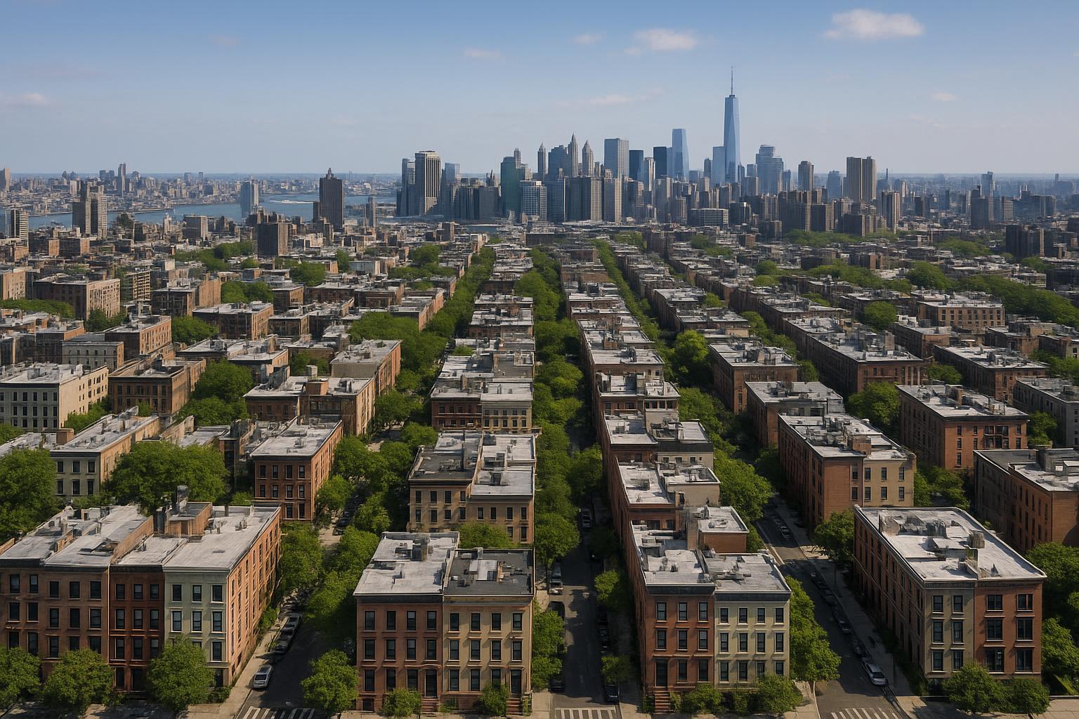
Drone photography captures a stunning aerial view of NYC, showcasing symmetrical rows of buildings with a backdrop of the iconic skyline.
Drone Photography NYC: Transforming Real Estate Listings with Aerial Perspective
When it comes to property marketing, drone photography NYC is radically changing how real estate professionals showcase listings. With buyer attention shifting online, dynamic visuals like aerial real estate photography are now a must-have for competitive agents, hosts, and owners. In this article, we’ll break down how professionally executed drone real estate photography sets properties apart, increases visibility, and helps New York City listings stand out on every platform. Drawing on years of hands-on production experience throughout NYC, New Jersey, and neighboring markets, we’ll also highlight crucial considerations for agents—from regulatory compliance to maximizing ROI with professional media partnerships.
The Real-World Problem: Why Standard Photos Struggle in NYC’s Real Estate Market
Every media team serving agents and property managers in NYC has seen it: the frustration of an impressive listing stuck on page two, attracting lackluster engagement despite a great address. Whether marketing a high-rise in Manhattan, a brownstone in Brooklyn, or a new rental in Jersey City, common pain points include:
- Low Click-Through Rates & Weak Online First Impressions:
Flat, ground-level photos miss the scale, setting, and excitement buyers and renters crave. Properties with standard images blend together, making it challenging for agents to grab interest in a saturated field. - Limited Buyer Imagination:
Empty rooms and generic curb shots rarely inspire viewers to see potential. With so much competition, listings need storytelling power to help prospects picture themselves living there. - Inconsistent Branding & Visuals:
A patchwork of phone photos, misaligned edits, and low-light shots undercuts professionalism. Especially with new developments or luxury listings, inconsistent content can slow offers and confuse buyers. - Obscured Neighborhood Context:
Many NYC buyers care just as much about amenities, outdoor spaces, and proximity to landmarks as about interiors. Traditional photography often fails to capture the property in its broader, walkable context.
We've seen listings with fantastic features underperform simply because the visuals couldn't communicate the property's unique story or setting.
What Experienced Media Teams Know
Having captured thousands of listings, the core lesson is that visually rich, well-composed media drives both emotional and practical engagement. In NYC and NJ, subtle operational details make a surprising difference. Here’s what real-world production experience reveals:
- Lighting and Timing Matter:
Aerial shots taken at golden hour can flood a rooftop or terrace with warm, inviting light, making outdoor amenities shine. Conversely, midday harshness can flatten the best features if not handled with care. - Preparation is Critical:
Before every drone shoot, our team walks the property, assessing logistics (roof access, surrounding obstructions, time of day) so that every frame delivers maximum impact. We alert clients ahead of time about clearing patios, prepping rooftop furniture, or even temporarily relocating vehicles to boost curb appeal from above. - Framing and Context:
Choosing the right altitude, angle, and focal length isn’t guesswork. For high-rises, we often recommend showcasing skyline views or nearby parks; for townhomes, a sweeping neighborhood approach captures the charm of tree-lined blocks. We always observe local airspace restrictions and carefully balance creative ambition with flight safety. - Editing for Accuracy and Beauty:
Aerial HDR shots, with true vertical correction and blue sky replacement, help listings pop without distorting reality. We know that window glare, “keystoned” buildings, or unbalanced shadows can ruin otherwise valuable shots—so every image undergoes careful review by an editor with deep NYC property knowledge.
How RealtaSnap Solves It: Reliable, Compliant, and Consistently High-Quality Drone Real Estate Photography
At RealtaSnap, our mission is to make sure every listing tells its best story—on time and fully compliant. Here’s how we approach drone photography for NYC and NJ real estate:
- Comprehensive Pre-Shoot Planning:
We evaluate every property for airspace, roof access, and legal compliance under FAA Part 107 before ever taking off. Our pilots are licensed, insured, and experienced with dense urban flight, including the tallest of high-rises and complex neighborhood layouts. - Premium-Grade Aerial Visuals:
Using 4K and HDR-equipped drones, we capture ten carefully composed aerial images per session with professional-grade color correction and blue sky replacement as needed. Add-on services like aerial video and combined photo/video packages are also available for a holistic marketing splash. - Storytelling-Focused Production:
Our process always highlights amenities like roof decks, pools, gardens, nearby parks, and building entrances. We take care to capture proximity to subways, green spaces, and local highlights, helping buyers imagine life both in and around the property. - Fast Turnaround, Reliable Delivery:
RealtaSnap’s workflow is built for urban professionals’ tight deadlines. Most drone photo and video shoots are delivered within 24-48 hours, ready to post on MLS, Zillow, StreetEasy, social media, and branded sites. - Regulatory and Safety Compliance:
Every flight is evaluated for FAA airspace classification, and operations in controlled areas are only done when proper authorization is granted. If additional permits (such as NYPD or city special event clearance) are required, we advise upfront. Not all sites are flyable—but when they are, we make every legal preparation for safe, compelling shoots【20:9†RealtaSnap_Service_Execution_Policy_MASTER.docx】. - Pricing Transparency:
- 10 Aerial Photos: $209, including on-site HDR capture and editing
- Aerial Video: $229 for a 1-minute professionally cut 4K video
- Photo & Video Bundle: $299 for 10 aerial images plus 1-minute video
All prices and information are subject to change. Information is deemed reliable but not guaranteed【20:0†RealtaSnap_Rate_Sheet_MASTER.docx】.
See details and booking options here: RealtaSnap Drone Photography & Videography NYC.
Benefits of Choosing RealtaSnap for Drone Real Estate Photography
- Licensed, insured drone pilots ensure regulatory compliance.
- Detailed pre-shoot property and airspace assessment.
- On-site HDR aerial images with sky replacement if needed.
- Contextual neighborhood, amenity, and architectural coverage.
- 24–48 hour turnaround on most shoots.
- Seamless online booking and transparent pricing.
- All post-production by editors specializing in NYC/NJ real estate.
- FAA Part 107–compliant operations backed by local experience.
- Add-on video, social media, and virtual staging options available.
- Dedicated customer support for NYC and NJ markets.
Why This Matters in the NYC / NJ Market
Aerial photography isn’t just a trend; in NYC and New Jersey it’s a necessity. The sheer verticality of the city, the diversity of properties, and the density of competition make first impressions critical. Buyers expect to see not only interiors and exteriors, but also terraces, communal spaces, skyline views, and proximity to amenities. Neighborhood context—rooftop access, neighboring parks, and even bustling streetscapes—frequently tip the scales for urban buyers and renters.
With shortlisting happening on mobile and listing platforms like StreetEasy, Zillow, and Realtor.com, compelling aerial content boosts click-through rates and encourages site visits. Suburban listings also benefit, with aerials exposing yard size, curb appeal, and proximity to transportation, giving agents a strategic edge.
Comparison with Traditional or Lower-Quality Alternatives
Agents relying on hastily snapped phone shots, uncorrected images, or DIY drone flights often end up with distorted perspectives, poor lighting, and generic presentations. We’ve seen self-shot photos that cut off amenity spaces, overlook unique building features, or misrepresent scale—leading to buyer disappointment and slower offers. Lower-quality providers sometimes disregard airspace restrictions, risking legal and safety issues that can backfire for agents and owners.
By contrast, RealtaSnap’s team leverages years of local production expertise, refined post-process orientation, and robust compliance protocols to deliver consistent, showcase-ready results every time. This helps agents maintain branding consistency, set higher perceived value, and ultimately achieve stronger market traction.
Conclusion & Call to Action
Elevate your listings with the power of professional drone photography NYC buyers and renters expect. In a market where first impressions dictate listing performance, RealtaSnap’s seasoned team delivers top-tier aerial real estate photography—helping you capture attention, earn trust, and drive results, all with unrivaled reliability and compliance. Discover more and schedule your shoot today:
https://www.realtasnap.com/drone-photography-videography-nyc
For a full suite of real estate media solutions serving New York City, New Jersey, and surrounding areas, visit RealtaSnap.com for service details and booking.
Frequently Asked Questions
1. Are drone photos and videos legal in New York City?
Yes, but all drone activity for real estate marketing must comply with FAA Part 107 rules. Additional local restrictions often apply, especially in dense urban areas. RealtaSnap uses licensed, insured pilots who handle airspace assessments and ensure every shoot meets legal and safety standards for every borough【20:9†RealtaSnap_Service_Execution_Policy_MASTER.docx】.
2. Can drone photography capture my building’s neighborhood and amenities?
Absolutely. Our process is designed to highlight what makes each property unique, including rooftop spaces, amenities, parks, and nearby attractions—always based on pre-shoot assessments and client goals. This approach helps online shoppers visualize both the property and its larger context, which is crucial for NYC and NJ buyers.
3. What if my property is in a restricted airspace, or I don’t have roof access?
Some locations do limit aerial coverage for safety and legal reasons. We assess every site in advance to let clients know what's possible, and we’ll advise on alternatives—such as ground-based wide-angle shots, virtual staging, or custom video tours—to ensure your listing still stands out. With RealtaSnap, you’ll always get honest recommendations and creative solutions tailored to NYC and NJ’s unique challenges.
For the most reliable, visually powerful aerial and drone real estate photography, trust RealtaSnap to help your NYC or NJ property rise above the competition.