Drone Photography’s Influence on the Presentation of NYC Real Estate Listings
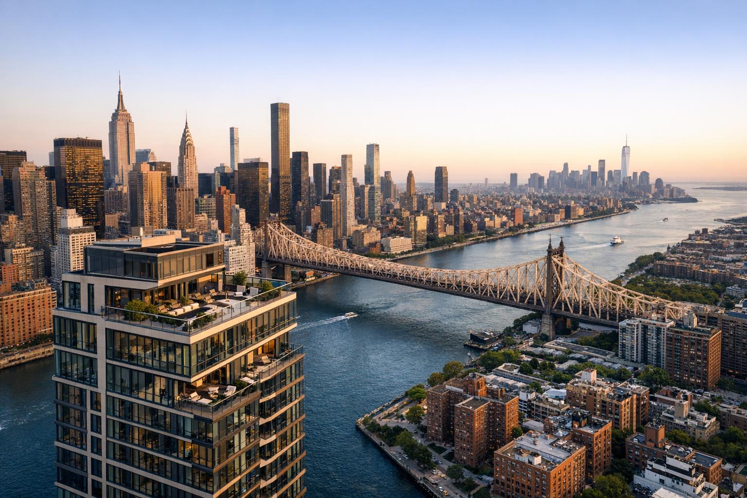
Drone photography captures a stunning view of a cityscape dominated by a large bridge, with towering skyscrapers and a prominent building showcasing modern real estate.
Introduction
Drone photography real estate services have become a game-changer for agents, brokers, and property managers looking to capture the true scale, setting, and selling potential of urban homes in the fiercely competitive New York City and New Jersey markets. In this in-depth guide, you’ll learn how aerial photography for real estate delivers powerful first impressions, attracts motivated buyers, and overcomes the unique challenges of listing properties in densely built environments. Drawing on years of real-world expertise, our team at RealtaSnap will share what sets effective real estate drone services apart—including essential compliance with local and FAA regulations, operational tips for a flawless shoot, and why partnering with a specialist ensures your listings stand out and stay compliant.
The Real-World Problem
Most New York City and northern New Jersey listings struggle to break through. The main culprits? Listings bogged down by stale imagery, awkward room angles, poor lighting, misrepresented exteriors, and unremarkable roof or amenity views. Take a look at any property portal: You’ll find cell phone photos cropped tight on cluttered rooms, distorted verticals, washed-out exteriors, and little sense of neighborhood context. When buyers can’t see the full story at a glance—especially exteriors, proximity to green spaces, rooftop decks, or skyline views—they click away.
For condos, co-ops, and high-rises, these limitations are magnified. Building layouts may mask a penthouse’s wraparound terrace, a townhouse’s private garden, or a unit’s proximity to city amenities. Inventory moves fast, so lackluster media often means properties sit longer, attract fewer inquiries, and potentially sell for less. An uninspired gallery or generic slideshow can undermine branding and leave hosts or agents frustrated by low engagement, fewer shares, and disappointing open house turnout.
What Experienced Media Teams Know
Seasoned real estate media professionals know that great aerial photography for real estate hinges on planning, timing, and technical execution—especially in an urban environment. Here’s what the pros pay attention to:
- Timing and Lighting: For cityscapes, the ideal time for drone flights is early morning or late afternoon when light is softer, shadows add dimension, and the city looks alive without harsh glare or deep shadows. Golden hour can add dramatic warmth to skyline shots and rooftop amenities.
- Framing and Site Preparation: Pre-scouting the building for roof access allows us to capture the property from advantageous angles, minimizing visual clutter from neighboring structures while maximizing wow-factor. We coordinate with property management for access and clear communication on timing.
- FAA and Local Regulations: In New York City, drone flights demand strict adherence to FAA Part 107 rules, thorough airspace reviews, and, in many cases, prior authorizations for controlled airspace. Not every site can be flown, especially near major infrastructure or restricted zones, and our pilots always conduct on-site risk and airspace assessments.
- Workflow Reliability: Experienced teams arrive prepared, with backup batteries, pre-flight checklists, and a plan for inclement weather or last-minute restrictions. Post-shoot, professional editing corrects for lens distortion, balances exposures, and can replace overcast skies with vibrant blue if needed.
How RealtaSnap Solves It
At RealtaSnap, we’ve built our reputation on reliable, high-impact, and regulation-compliant real estate drone services in New York City and New Jersey. Every drone photography shoot begins with a tailored approach: site review, roof access coordination, airspace checks, and clear communication with property managers ensure no surprises on the day of your shoot. Our pilots are FAA Part 107 certified and experienced in navigating the patchwork of city-specific regulations—ensuring your aerials are not just beautiful, but fully compliant.
We understand the stakes of a listing launch. That’s why we deliver sharp, professionally edited aerials and short 4K highlight videos with quick turnaround—typically within 24–48 hours. For all aerial photography for real estate, we use HDR capture for maximum dynamic range, offer blue sky replacement where needed, and use framing that highlights property lines, amenities, and surrounding features. Not every site is flyable, but we’re proactive about communicating any constraints, so your team can make informed marketing decisions.
Ready to see your property from every angle? Discover RealtaSnap’s NYC drone photography services here.
Benefits of Choosing RealtaSnap
- FAA-certified, NYC and NJ experienced drone operators
- Transparent regulatory compliance and site assessments
- 4K HDR aerials, blue sky replacement, and professional editing
- Rapid 24–48 hr turnaround for most projects
- Real-world guidance—no overpromises, just results
- Personal communication and support throughout the process
- Easy online scheduling tailored to busy urban agents
- Consistent branding and visual narrative across all listings
- Competitive, published pricing with no hidden fees
Why This Matters in the NYC / NJ Market
In dense metro areas like Manhattan, Brooklyn, Jersey City, and Hoboken, buyers expect visually engaging listings that quickly communicate both the property itself and its urban context. Views, outdoor spaces, and proximity to parks or cultural landmarks are prized features—and often difficult to showcase with ground-level photos alone. Furthermore, buyers (and renters) move fast in these competitive urban markets. A strong aerial presence boosts click-through rates, encourages longer gallery engagement, and distinguishes your listings from the all-too-common scroll of repetitive interiors.
NYC and NJ media regulations also demand experience: flight restrictions, building permits, and varying rules about roof access and photography make DIY options or generic providers risky. Working with a specialist like RealtaSnap means smoother shoots and fewer headaches.
Comparison with Traditional or Lower-Quality Alternatives
Standard listing photos taken from the sidewalk or out a window rarely do justice to a property’s setting or architectural appeal. Phone snapshots produce warped perspectives, visible window glare, and inconsistent results—especially in tall or tightly spaced buildings. Lower-cost, non-specialized vendors may not understand NYC-specific restrictions or show up with the wrong gear, putting your listing (and your liability) at risk.
Traditional approaches miss opportunities to capture:
- Top-floor terraces with skyline backdrops
- Courtyard and amenity decks that add sale value
- Building façade and location context for out-of-area buyers
- Adjacent parks, transit, or waterfronts that drive click-through
RealtaSnap’s approach, developed through hands-on experience across NYC and NJ, means visual cohesion, reliability, and complete confidence that all original and regulatory detail is covered—every time.
Conclusion & Call to Action
Drone photography has redefined what’s possible in real estate marketing, especially for properties in New York City, New Jersey, and the wider metro area. With RealtaSnap, you get more than beautiful images—you get a partner who knows the stakes, understands the market, and ensures your listings are both stunning and compliant. Let your next listing take flight with RealtaSnap’s real estate drone services. Explore our full offerings at www.realtasnap.com and see how effortless great property marketing can be.
Frequently Asked Questions
1. Can you fly drones anywhere in New York City or New Jersey for real estate shoots?
No, flights are subject to FAA airspace classifications, weather, neighborhood restrictions, and local property rules. Some rooftops and neighborhoods—especially near airports or in controlled airspace—require special authorization and may not be feasible for drone photography. RealtaSnap’s pilots are experienced in NYC and NJ compliance, so we’ll always assess and inform you upfront about what’s possible.
2. How do I prepare my property for an effective aerial shoot?
It’s best to ensure roof, terrace, and outdoor spaces are tidy and accessible. We recommend notifying building management and securing necessary access well in advance. Roof access in high-rises can dramatically improve the range and visual impact of drone shots. Clear communication and coordination with our team mean you’ll get the most out of your shoot.
3. What if I need the aerial photos or video urgently for a live listing?
RealtaSnap understands the pace of NYC and NJ real estate. In most cases, our drone photography and video files are professionally edited, color-corrected, and ready for delivery within 24–48 hours after the shoot. We’re committed to on-time, reliable turnaround to keep your listing strategy moving forward.
All prices and information are subject to change. Information is deemed reliable but not guaranteed.