Drone Photography’s Influence on Modern NYC Real Estate Marketing
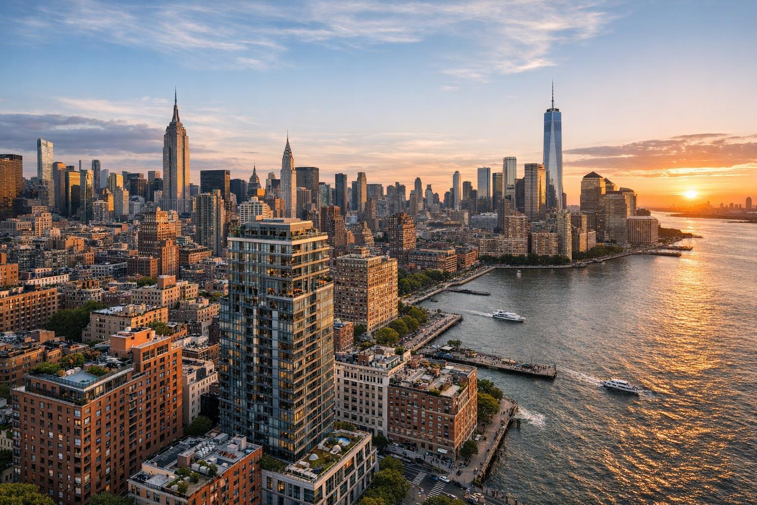
Drone photography captures the stunning New York City skyline at sunset, with iconic skyscrapers and the Hudson River in view.
How Drone Photography in NYC Is Transforming Real Estate Marketing
Drone photography NYC isn’t just a trend—it’s transforming how properties are marketed across the five boroughs and New Jersey. In today’s fast-paced market, real estate drone services have become a go-to tool for achieving standout listings, especially as buyers expect immersive visuals and complete context before ever setting foot on site. If you want to understand why aerial real estate photography has become a cornerstone of successful marketing for both residential and commercial listings—and how to maximize its impact in neighborhoods like Manhattan, Brooklyn, or premium suburban markets—read on. This article draws on deep field experience to show you exactly how top teams harness aerial content, what to look for in a drone media provider, and real-world practices for getting results.
The Real-World Problem
Most agents, hosts, and property managers in NYC, NJ, and nearby markets share the same challenges: standing out in crowded listing portals, making a strong first impression, and giving buyers the confidence to take next steps—fast. It’s tough enough to get attention with standard ground photography, especially when many buildings are surrounded by dense skylines, blank rooftops, or small, shaded backyards.
Here’s what we see every day in the field:
- Low click-through rates. Listings with only ground-level shots often blend in, especially in Manhattan high-rises or brownstone clusters where curb appeal isn’t obvious from the street.
- Weak first impressions and buyer hesitation. Without aerial context, buyers can’t tell if there’s a roof deck, skyline view, or if the property overlooks a park, major intersection, or neighboring development.
- Limitations with lighting and space. North-facing backyards get lost in shadow. Small urban footprints can’t showcase outdoor amenities or nearby transit in a single shot.
- Struggles with imagination and engagement. Empty lots or loft-like commercial spaces leave buyers guessing about layout, scale, and neighborhood context.
- Inconsistent visual branding. Switching between media providers, rushed shoot scheduling, or using unlicensed drone pilots can result in mismatched edits, odd color profiles, or incomplete visual stories.
- Compliance and feasibility headaches. NYC presents unique pilotage hurdles: FAA restrictions, roof access issues, and legal requirements make “DIY drone” approaches unreliable and, in some cases, outright risky.
For busy agents in Brooklyn, Jersey City, or the Upper West Side, these pain points don’t just slow down a sale—they can put client relationships and commissions at risk.
What Experienced Media Teams Know
Here’s what sets experienced real estate photographers and drone operators apart in NYC and NJ markets:
- Timing and lighting are everything. We plan shoots for when the sun is at the best angle for your property: late-morning for east-facing buildings, golden hour for dramatic rooflines. This requires deep familiarity with both the property and the microclimate of the block.
- Drone flights in urban airspace need advanced preparation. Pros know FAA Part 107 inside and out—plus, they check NOTAMs and local TFRs daily, and get explicit building access, ideally via roof.
- Framing for context means going beyond “beauty shots.” The most successful aerial real estate photography combines proximity (framing the facade or rear yard) with wide, contextual establishing shots, showing proximity to parks, skyline, water, or transit. For commercial and luxury residential, this context sells the lifestyle, not just the floor plan.
- Every listing platform displays media differently. Some auto-crop thumbnails, others prefer certain aspect ratios; knowing how to sequence and deliver alternate cuts (including vertical shots for Reels/Stories) ensures maximum engagement on Zillow, StreetEasy, MLS, and social media alike.
- Real staging and minimal post. Drone shots of occupied rooftops or staged yards require true-to-life prep—not overediting—which is why the best teams coordinate with on-site stagers, gardeners, or building supers beforehand.
From live project execution: We’ve arranged early-morning roof access in Midtown to beat both the sun and end-of-day airspace restrictions, and worked with brokers to sequence the drone shots so that a waterfront view leads the virtual tour, followed by interior highlights, giving out-of-state buyers instant context.
How RealtaSnap Solves It
At RealtaSnap, we’ve designed our aerial real estate photography services around the realities of NYC and NJ streetscapes, vertical neighborhoods, and regulatory complexities. Here’s how:
- Expert FAA-licensed pilots. Every drone shoot is handled by an experienced operator who understands bustling city airspace, neighborhood restrictions, and property-level feasibility. Our pilots always assess legal, safe flight paths and obtain necessary building and roof access approvals.
- HDR, 4K, and blue-sky image replacement. We deliver high-resolution, professionally corrected aerials and sweeping cinematic 4K video, even when weather isn’t perfect—backed up by reliable turnaround in as little as 24 hours.
- Full integration with listing media. Our drone content is sequenced and color-matched with interior photos, video tours, and floor plans, delivering a cohesive visual package that’s optimized for every major portal.
- On-demand scheduling and transparent pricing. Drone photo packages start at $209 for up to 10 fully edited images or $229 for a polished 60-second 4K video. Combined photo and video packages are $299. (All prices and information are subject to change. Information is deemed reliable but not guaranteed.)
- Specialized editing and compliance. No overpromising, no risky flights: If a location’s airspace is closed, or roof access isn’t feasible, we’ll coordinate with you to reschedule, adjust the flight path, or propose creative workarounds.
- True local coverage. Whether you’re listing in SoHo, Williamsburg, Jersey City, or Montclair, our team knows the quirks—urban canyons, high-rise wind tunnels, and the right visual angles for showcasing your listing’s value amidst cityscape competition.
You can book a session in minutes using our streamlined online portal or via our mobile app for rapid scheduling—perfect for last-minute new developments or just-listed exclusives.
Benefits of Choosing RealtaSnap
- Local FAA-licensed drone pilots, always insured
- 4K and HDR imagery with blue-sky replacement
- Next-day turnaround for most shoots
- Seamless integration with photo, video, and floor plans
- Customized angles for each listing’s unique selling points
- Case-by-case feasibility assessment—no risky flights
- One-stop scheduling for full media packages
- Familiarity with Manhattan, Brooklyn, and NJ airspace
- Transparent pricing, no hidden fees
- Real support from real photographers every step
Why This Matters in the NYC / NJ Market
In New York City and Northern New Jersey, aerial real estate photography isn’t optional—it’s the new standard. Luxury listings in Manhattan, rowhouses in Brooklyn, and waterfront condos in Jersey City all compete in markets where buyers want full transparency and emotional engagement before ever contacting a broker.
- Buyers expect an immersive sense of place. Rooftop gardens, skyline vistas, and proximity to amenities need to be highlighted visually. Listings that neglect aerial content leave too many questions unanswered.
- Small footprints and vertical living. NYC’s architecture means it’s tough to capture true scale or context from street level. Aerial media bridges that gap instantly.
- Renter and buyer competition is fierce. Fast-moving seasonal inventory—especially in hot boroughs—demands quick, polished, and consistent new media so agents aren’t left behind.
- Listing platforms favor standout visuals. High-quality drone images get prioritized on search portals and attract more clicks, particularly in crowded luxury and multifamily categories.
Comparison with Traditional or Lower-Quality Alternatives
- Phone photos miss façade details, roof decks, and dramatic skyline angles—especially in dense NYC neighborhoods.
- Rushed, unlicensed drone pilots can lead to canceled flights, incomplete deliverables, or even regulatory fines.
- Inconsistent editing often results from splitting shoots between generic providers, leaving media packages fragmented in look and feel.
- Delayed delivery can derail a listing launch—especially in fast-moving markets where timing is crucial.
- Lack of coordination with staging or property prep leads to missed opportunities, like a photo session scheduled before rooftop planters are set or yard furniture is arranged for maximum effect.
Savvy agents now view seamless, coordinated, professionally edited drone content as table stakes for NYC and NJ listings.
How Aerial Content Complements Other Real Estate Media
At RealtaSnap, aerial footage is never a stand-alone extra—it’s integrated with:
- Interior photography: We match color profiles and lighting moods, so the transition from bird’s-eye exterior to sun-lit living room is fluid and evocative.
- Listing videos: Our drone shots set the stage and provide context, leading video tours with a “wow” factor that’s consistent across all cuts—horizontal for MLS, vertical for Reels and Stories.
- Virtual tours and floor plans: Overhead drone views help viewers instantly understand the layout, flow, and outdoor amenities before diving into 3D walkthroughs.
- Branding and property websites: Cohesive, high-quality drone and ground packages boost agent brands—resulting in more inquiries and higher trust from both sellers and buyers.
Case in point: When marketing a Brooklyn brownstone with a beautifully designed roof deck, our drone pilot captured sunset lighting that highlighted both the property and the Manhattan skyline beyond. Paired with golden-hour interiors, the listing generated more showings in its first week than comparable units without an aerial media package.
Conclusion & Call to Action
Drone photography NYC has redefined what it means to market properties with impact, especially in fast-paced urban and competitive suburban markets like Manhattan, Brooklyn, and New Jersey. If you’re ready to elevate your listings with consistent, high-quality real estate drone services, trust a provider with deep local experience and a proven workflow.
Want to see the difference for yourself? Explore our NYC drone photography and videography portfolio or learn more about how RealtaSnap delivers for agents like you at www.realtasnap.com/drone-photography-videography-nyc. For a complete overview of media solutions, visit www.realtasnap.com.
Frequently Asked Questions
1. Is it even possible to get drone shots of my NYC listing?
Absolutely, but it’s not always as simple as just bringing a drone. Airspace restrictions, local regulations, and roof access can make some addresses more challenging. With RealtaSnap, every drone shoot is planned by a licensed pilot who understands the nuances of NYC and NJ airspace. If we can’t fly at your location, we’ll propose creative alternatives to achieve the next best view—so you’ll never be left without a solution.
2. How quickly can I get my aerial photos and video?
For most listings, we deliver edited drone imagery (photo and video) by the next business day after the shoot, allowing agents to go live without delay. If weather or airspace issues occur, we proactively communicate and reschedule as needed. Our streamlined process is designed to support even the fastest-paced listing timelines.
3. What does it cost, and what’s included?
A package of 10 high-resolution drone photos starts at $209, a 4K video at $229, and a combined photo and video session at $299. Every package includes editing, blue-sky replacement, and seamless integration with your other listing media. (All prices and information are subject to change. Information is deemed reliable but not guaranteed.) For more, check out our full pricing options.