Drone Photography Near Me: What to Ask Before Booking for a Property Listing
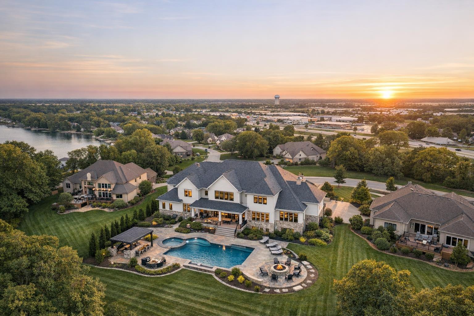
Drone photography captures a stunning suburban landscape at sunset, showcasing a luxurious house with a pool and a view of the surrounding neighborhood and lake.
Drone Photography Near Me: What to Ask Before Booking for a Property Listing
When most people search for drone photography near me, it's because they have a property that invites a view from above. Whether you're prepping a listing with extensive grounds, spectacular views, or a story that’s best told from the sky, getting aerial photos or video can bring invaluable context. But there’s a practical side to every drone request: not every property is a fit for aerial media, and not every address is actually flyable.
Having worked on real estate media projects in NYC, New Jersey, and the region, one truth holds: aerial media is most effective when it highlights something buyers or tenants won’t easily understand from ground level. That could be a private backyard, proximity to water, a multi-building layout, or even just a sense of scale that indoor photographs can’t capture.
Before booking a drone shoot, it’s worth some careful planning. Here’s how experienced real estate pros separate the listings that truly benefit from aerial coverage from those that might need a different approach—and the right questions to ask any provider before you schedule that shoot.
Purpose First: What Should the Aerial View Actually Show?
"Can a drone fly here?" is only the beginning. The better question is what an aerial angle will communicate to those looking at the listing. A top-down image can clarify property boundaries, reveal how outdoor amenities fit into the broader landscape, or showcase things like a water view or a grouping of buildings on a commercial site.
For agents and property managers, being clear on the intended use of drone imagery shapes everything that follows. Are you hoping to show a pool, rooftop, or wraparound deck? Do you need to clarify access points or highlight the distance to a waterfront or trails? A well-defined creative brief leads to more intentional, useful images.
Aerial property photography is often most helpful for:
- Expansive homes with grounds, gardens, or pools
- Waterfront properties where the relationship to shoreline is essential
- Listings with roof decks, terraces, or large outdoor entertaining spaces
- Lots in unique settings, like secluded land or mountain views
- Properties that span multiple structures or have a large commercial footprint
- Construction projects needing a broader view of progress or site context
Conversely, drone coverage can be unnecessary if the building is boxed in by neighbors, sits on minimal land, or is in an environment with strong flight limitations. In those cases, well-planned exterior photography or curated ground-level video may do a better job.
Getting specific about what features you want to highlight—“We want to show the pool’s privacy and proximity to the water,” for example—gives the provider a much clearer target than simply asking for generic drone shots.
Photos, Video, or a Mix? Making the Right Choice
Not all aerial media is created equal. For real estate, still photos and video clips serve very different roles.
- Aerial Photos: Great for property websites, MLS galleries, and marketing materials when you need clear, scannable images that show outdoor assets, parking, rooflines, and general lot layout. A handful of strong, well-edited drone photos usually does more for a listing than a dozen redundant angles.
- Aerial Video: More effective when movement tells the story—think flyovers to reveal scale, or sweeping entrance shots to create a sense of arrival. Aerial video is most useful when it’s woven into an on-site listing video, versus a standalone reel of dramatic but disconnected visuals.
For some properties, photos are enough. If you’re focusing on setting, outdoor amenities, or relationship to nearby features, the right handful of images can make the point. For listings where the journey through a site, dramatic elevation changes, or approach shots are useful, consider pairing aerial photos with video for a comprehensive package.
What to Ask Before Booking Drone Media
Booking drone photography for a property isn’t like ordering basic listing photos. The logistics and feasibility are determined not just by what’s visible on Google Maps, but by real constraints that might only be clear on location. Here are the main points experienced agents and property managers clarify first.
1. Is the Address Actually Flyable?
Before anything else, confirm if the location allows drone operation. Factors like FAA regulations, restricted airspace, proximity to airports or heliports, dense urban structures, event activity, access to safe launch areas, and weather all play a role. In the NYC area, this is particularly crucial—the presence of nearby airports or stadiums can put some addresses off-limits, even when the aerial angle would otherwise be ideal.
No reputable media provider should guarantee that a drone flight is possible until the address and the surrounding circumstances have been reviewed. Local knowledge and transparent communication are essential.
2. What Kind of On-Site Access Is Available?
The ideal launch point makes safer, more versatile flights possible. In suburban New Jersey or less dense areas, a driveway or open yard is often sufficient. In Manhattan or Brooklyn, a roof, terrace, or inner courtyard may be required, and sometimes buildings place restrictions on roof use or need advance notice for access.
When planning an aerial shoot, clarify:
- Access points: roof, terrace, parking lot, or backyard
- Who is available to provide access
- Any approval needed from building or property management
- Security, elevator, or access schedules
- Timing of other site activity (deliveries, events, pedestrian traffic)
Remember, even when roof access seems like the solution for dense city blocks, airspace and site safety are still daily considerations.
3. What Deliverables Will Be Provided?
Ask in detail about the finished product—not just “drone package” or “video included.” Are you receiving a set number of fully edited images? Is video edited for immediate use, or simply raw clips? How long is the video, and in what format? Are you able to specify the exterior features you’d like prioritized?
At RealtaSnap, for example, drone packages include:
- 10 HDR aerial photos, edited and delivered for listings
- One-minute edited 4K aerial video
- Or a combined photo and video option
Discussing these details ahead of booking means fewer surprises, and ensures the results focus on your listing’s priorities.
4. How Do You Handle Weather and Flight Limitations?
Drone operations depend heavily on the weather—not just how the sky looks, but wind, visibility, and overall flying conditions. Professional drone providers will reschedule or adjust the shoot when it’s not safe or compliant to fly. If you’re bundling aerial media with ground photos or video, ask how those services are handled if the drone segment gets postponed.
5. Is the Provider Focused on Real Estate?
Experience with drones is one piece; experience with property media is another. For real estate, you want a provider who frames images in ways that clarify scale, layout, and selling features—not just create dramatic views for the sake of aesthetics. This means understanding what makes a roofline, approach angle, or exterior relationship useful for buyers (and what doesn’t).
Look for a provider who talks about:
- Composition and property scale
- Picking angles that answer practical questions for buyers or tenants
- Integrating aerials with ground-based assets for a cohesive gallery or video
Local Realities: NYC and New Jersey Considerations
Drone media in NYC and New Jersey means dealing with some of the most variable conditions imaginable. In many New Jersey suburbs, open yards and detached homes make aerial coverage much simpler. In North Jersey, commercial sites and large footprints can benefit from aerial context, whether that means parking layout, street access, proximity to transit, or acreage.
In Manhattan and Brooklyn, dense neighborhoods, narrow streets, and strict airspace controls combine with logistical factors like roof access and pedestrian flow to make drone work a case-by-case process. Sometimes, the answer is that an address simply can’t be safely or legally flown. This is why booking with a local media provider familiar with city and state rules can save time and disappointment—especially when coordination with a doorman, manager, or multiple site contacts is part of the workflow.
RealtaSnap serves New York City (all boroughs) and New Jersey statewide, handling drone bookings based on address-specific feasibility and conditions.
Getting the Most Out of Your Drone Media Request
A successful drone shoot requires more than just an address and a request. It pays to share property details, intended uses for the footage, access instructions, and any relevant scheduling factors up front. The more context you provide, the more likely you are to get the right kind of visual coverage.
Some quick tips:
- Specify the property type (home, lot, new construction, commercial, etc.)
- Indicate occupancy status (vacant, occupied, under construction)
- Share access info (roof, yard, parking, on-site contact)
- Point out any exterior features to highlight (pool, roof deck, land boundaries)
- Note any building restrictions (approval, elevator policy, security)
- Explain how you’ll use the images (standalone, in a video, social media, etc.)
For commercial properties, clarity about active zones and operating hours is essential for both safety and site coordination. For residential listings, simple pre-shoot preparation like moving vehicles, arranging patio furniture, or securing gates can make a big impact in how orderly and appealing the property looks from above.
Set Expectations: Not Every Address Is Flyable
It’s tempting to advertise stunning aerial views before you’ve confirmed drone feasibility, but sometimes it’s not possible. Airspace restrictions, unpredictable weather, safety, limited access, or even an especially dense block can put aerial plans on hold. For all properties, but especially for drones, it’s best to treat aerial coverage as an option until it’s confirmed for your specific address.
At RealtaSnap, all drone work is reviewed for operational conditions and must comply with FAA Part 107 and other applicable regulations. If a property requires unique permits not covered by standard authorization, clients are responsible for the application process. Not every assignment can be accepted if conditions can't be met.
Drone media is designed for marketing—not for inspections, engineering analysis, or legal documentation. If you need highly specialized surveys or architectural analysis, those require different specialists.
Booking Aerial Media With RealtaSnap
If your listing is in NYC or New Jersey, you can check availability and book on-site aerial media with RealtaSnap directly. Visit www.RealtaSnap.com to enter your address, choose from drone photo, video, or a combined option, and include any specifics about access or features you want highlighted.
Appointment times display on the online calendar, and bookings should be made at least 24 hours ahead. Payment is handled through the website during checkout.
For listings that require a broader marketing story, drone coverage can be easily bundled with professional property photography or listing video—just specify your needs when you book.
Drone media is most valuable when it answers a real question that ground-level images can't. If your property’s setting, amenities, or outdoor scale will benefit from an aerial angle, share your details when booking so we can evaluate feasibility and help you make the most informed decision.
Visit www.RealtaSnap.com to get started.
FAQ
Question: How much is real estate drone photography with RealtaSnap?
Answer: Drone photography starts at $209 for 10 HDR photos. Aerial video is $229 for a one-minute 4K video. For a complete package, the combined photo-and-video option is $299. All drone bookings depend on confirmed flight feasibility for the specific address.
Question: Can every NYC property be photographed by drone?
Answer: Not every NYC property is flyable. Each address is evaluated based on FAA airspace, local restrictions, weather, physical access, and current safety conditions. Even when roof access is available, a flight may not be possible until the site is reviewed.
Question: Should I book drone photos, video, or both?
Answer: Book aerial photos if your listing needs clear exterior context—like lot boundaries, amenities, or the setting around a building. Aerial video is useful for showing movement, approach, or dramatic wide angles as part of a property film. If both would add value and context, a combined option offers a well-rounded aerial presentation.