How Drone Photography Is Shaping New Jersey Real Estate Marketing Strategies
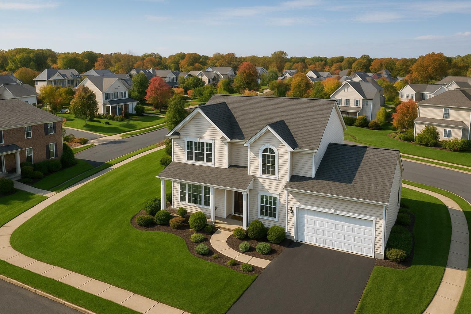
Drone photography in NJ captures a picturesque suburban neighborhood with well-manicured lawns and autumn foliage.
Drone Photography NJ: Elevating Real Estate Listings Where It Counts
When it comes to attracting serious buyers and renters in a competitive market, drone photography NJ is transforming how properties are showcased online. For real estate professionals across New Jersey and the greater NYC area, drone photography real estate solutions—and their high-impact aerial perspectives—are driving better listing performance, stronger first impressions, and more qualified leads from the start. In this article, you’ll learn why aerial real estate photography isn’t just an upgrade; it’s becoming the new standard for sellers who want results without compromise. You’ll also get actionable advice for agents and sellers, insight into NJ-specific regulations, and a peek into how experienced teams like RealtaSnap bring these visual advantages to your next listing.
The Real-World Problem: Why Traditional Listing Media Often Falls Short
Despite New Jersey’s diverse inventory—from modern condos in Jersey City to classic Colonials in Montclair—property photos are still the number one driver of clicks, showings, and offers. Yet, many listings underperform because:
- Static, low-angle shots limit a buyer’s sense of space and community context.
- Plain exterior photos fail to capture a home’s proximity to parks, transportation options, or shorelines—big selling points for NJ buyers.
- DIY or phone photography introduces uneven lighting, distortion, and missed details, making even staged homes appear underwhelming.
- Large lots, townhomes with shared amenities, or high-rises often look uninspired from the ground, missing out on storytelling potential.
- Empty outdoor spaces become lost opportunities that don’t connect with lifestyle-minded buyers hunting for outdoor living, privacy, or “wow” features.
- Listings blend together on platforms like Zillow, Realtor.com, and rental sites, reducing engagement and making agent branding inconsistent.
Experienced agents have seen how poor visuals lead directly to lower click-through rates, fewer showing requests, and slower activity—regardless of the property’s true value.
What Experienced Media Teams Know: From Field Challenges to Visual Wins
Having photographed and marketed thousands of properties across NJ and NYC, we’ve learned that small choices in production can make or break a listing’s success. When it comes to drone photography, real estate professionals rely on more than just having the right equipment—they count on nuanced process, regulatory know-how, and the ability to anticipate what works for both MLS and buyers:
- Optimal Lighting Matters: Aerial shoots need to be timed carefully—midday for even roof lines, golden hour for warm ambiance, and post-rain for deep greens and vibrant skies. Overexposure or harsh shadows can diminish an otherwise stunning lot or view.
- Framing and Location Context: We often scout locations in advance, determining what neighboring parks, schools, or transit lines can be highlighted. A single drone shot that frames a property’s proximity to the waterfront or Manhattan delivers instant context.
- Balancing Exposure Indoors and Outdoors: When pairing drone and ground photography, vertical lines and window exposures must be meticulously corrected to avoid distortion—a detail often missed by non-specialists.
- Regulatory Savvy: NJ’s tight patchwork of airspace (especially near NYC, airports, or controlled sites) means every shoot requires FAA-compliant pilots and site-specific planning. Not every lot, rooftop, or high-rise is cleared for drone flight, and that evaluation is essential to safe, legal, and successful results【20:5†RealtaSnap_Service_Execution_Policy_MASTER.docx】.
- Brand Consistency: Professional editing ensures HDR sky replacement, color correction, and the removal of visual distractions so every image reinforces the agent’s brand rather than introducing inconsistent visuals.
We’ve observed how a thoughtfully executed drone shoot—showcasing a home’s full lot, neighborhood, or unique architectural lines—can rapidly change a listing’s trajectory. Sellers and agents who invest in the right aerial content consistently see higher engagement, better perceived value, and faster buyer action.
How RealtaSnap Solves It
At RealtaSnap, drone photography isn’t a luxury add-on—it’s a critical visual tool for narrative-driven real estate marketing throughout New Jersey and NYC. Here’s what sets our process apart:
- Comprehensive Planning: Every drone shoot starts with a feasibility review to ensure flight safety, regulatory compliance, and the best lines of sight. We advise on timing, weather, and what to highlight for maximum listing impact.
- FAA-Authorized Operations: Our pilots operate under FAA Part 107, and all airspace conditions are analyzed in advance. We coordinate with agents about local restrictions, permitting needs, and access (such as secure roof access for urban properties)【20:5†RealtaSnap_Service_Execution_Policy_MASTER.docx】.
- Visual Quality, Delivered Fast: Listings move fast, especially in NJ’s most sought-after communities. We deliver fully edited drone photos (10 HDR images, 1-hour session, $209) or video ($229 for a fully produced 1-minute reel) within tight timeframes—ready for MLS, social, and agent marketing. Our combined drone photo + video package offers maximum value at $299 for bundled delivery.
- Natural Integration With Listing Media: Our teams coordinate drone and ground photography for cohesive presentation. Every image is balanced for color, exposure, and clarity, delivering portfolio consistency for agents across multiple listings.
- Strict Editing Standards: Post-production includes sky replacement, vertical line correction, and distraction removal to maximize curb appeal and eliminate common flaws seen in unedited aerial shots.
- Practical Guidance for Agents and Sellers: Prior to each shoot, we provide prep tips—trimming the lawn, moving vehicles, opening pools, and prepping exterior features—to ensure every drone image tells the full story of the property.
Our hands-on approach helps sellers, managers, and agents avoid issues with unreadable roof lines, shadow-heavy exteriors, or media that fails to differentiate a listing from local competition.
All prices and information are subject to change. Information is deemed reliable but not guaranteed【20:0†RealtaSnap_Rate_Sheet_MASTER.docx】.
If you’re interested in learning more or want to schedule a session, visit our Drone Photography & Videography page or book directly here.
Key Benefits of Choosing RealtaSnap
- FAA-authorized pilots for all New Jersey and NYC assignments
- Full insurance and up-to-date compliance
- Consistent turnaround—drone media delivered in 24–48 hours
- HDR, blue sky replacement, and advanced editing included
- Detailed planning for every airspace and location type
- Seamless integration of drone, ground, and interior visuals
- Transparent rates and bundled service options
- Dedicated support and prep resources for every client
- Built-in brand consistency for listing portfolios
Why This Matters in the NYC / NJ Market
New Jersey and NYC listings face unique demands—dense competition, a diversity of property types, and buyers who expect a sophisticated digital presentation long before an in-person tour. In NJ alone:
- Buyers often weigh commute distance, school proximity, and neighborhood lifestyle—all captured best by aerial real estate photography.
- The market’s split between suburban and urban listings rewards agents who can showcase both expansive lots and skyline views in a single listing.
- Premium rental and luxury properties in boom towns like Hoboken, Edgewater, and Westfield see measurable listing performance boosts from high-quality drone assets.
- Listing platforms like Zillow and Realtor.com favor gallery cover images and video thumbnails that instantly set the scene—aerials reliably outperform basic street-level shots for CTR and lead generation.
For brokers, hosts, and managers across NYC and NJ, leaning into the right visuals isn’t just smart marketing; it’s the minimum standard for attracting quality buyers and tenants.
Comparison With Traditional or Lower-Quality Alternatives
Choosing to skip drone photography—or settling for generic providers—carries risks:
- Phone Photos: Lacking stabilization, altitude, and exposure control, phone aerials (or ground photos alone) miss crucial context, making listings appear flat and generic.
- Rushed Operators: Inconsistent peer-to-peer drone “shooters” may deliver poor framing, color variances, or even break FAA rules that can lead to listing takedowns.
- No Editing or Coordination: Without professional editing (color correction, sky replacements, distraction removal), exterior and aerial shots look muddied and out of sync with brand visuals.
- Delayed Delivery: Waiting days for finished media means new listings go live late, missing peak viewing windows and costlier price reductions.
By contrast, RealtaSnap’s process ensures all technical, regulatory, and creative variables are managed transparently—helping agents avoid disruptions, maintain branding, and focus on selling.
Conclusion & Call to Action
Drone photography NJ isn’t just a marketing trend—it’s a practical, results-driven upgrade for any listing that needs to stand out fast. With tight timelines, regulatory complexity, and high buyer expectations across the NYC and NJ markets, professional aerial real estate photography is a worthwhile investment for serious sellers and agents.
RealtaSnap’s experienced team brings both creative vision and technical compliance to every shoot, enabling you to showcase properties at their very best—with speed and confidence. Ready to elevate your next listing? Discover our full suite of real estate photography and drone services at www.realtasnap.com and explore service options for your next NJ or NYC listing.
Frequently Asked Questions
1. What if my property is in a controlled or restricted airspace in NJ or near NYC?
Many parts of NJ and greater NYC fall under FAA-regulated airspace, especially near airports or certain municipalities. RealtaSnap’s experienced pilots carefully review every address in advance, ensure compliance, and will either secure proper clearance or advise you immediately if aerial photography isn’t feasible for your site. When in doubt, our team finds the best workaround to capture your location’s value safely and legally.
2. How should I prepare my home or building for a drone photography shoot?
To make the most of aerial real estate photography, clear driveways and remove vehicles, prep outdoor spaces (like patios or pools), trim landscaping, and avoid trash bins or exterior clutter. Our team always provides a prep checklist before each session, and we’re happy to coordinate any unique needs or scheduling to work around weather and sunlight for optimal results.
3. How quickly will I get my edited drone photos or video from RealtaSnap?
We understand that time is of the essence in the NJ/NYC market. RealtaSnap typically delivers fully edited drone photos or videos within 24–48 hours of the shoot, ensuring you can launch or refresh your listing right away. Our process is designed to keep you moving quickly and confidently from photo day to live listing.