Expert Insights on Drone Photography in New Jersey Real Estate: Trends and Impact
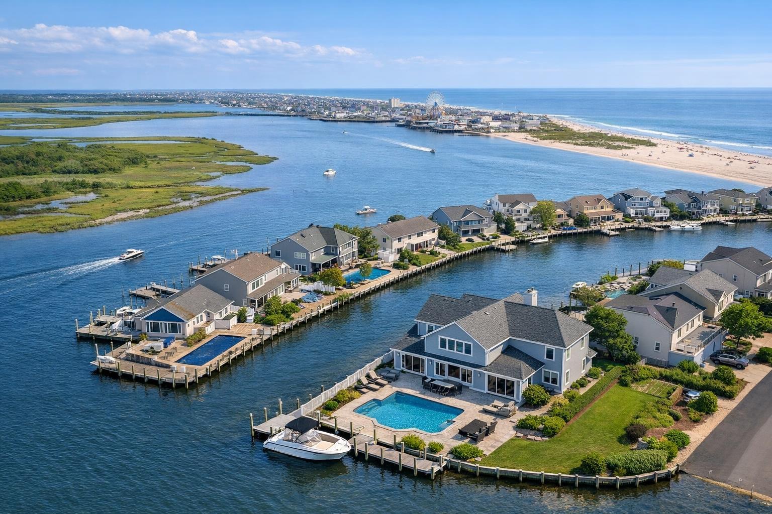
Drone photography in NJ captures a stunning aerial view of waterfront homes, a river, and a nearby beach and amusement park.
Drone Photography NJ: Transforming Real Estate Marketing with Aerial Perspective
In New Jersey’s ultra-competitive property market, “drone photography NJ” is more than a passing trend—it’s a crucial tool for agents, hosts, and sellers looking to make their listings stand out with attention-grabbing visuals. Leveraging aerial real estate photography in New Jersey and surrounding markets can be the difference between a listing that lingers and one that leaps off the page. In this article, you’ll learn how professional drone services elevate real estate marketing, what clients can expect from experienced providers, and why high-quality aerial content translates directly to better listing engagement and results. We’ll also address the unique compliance and operational requirements for aerial real estate media in NJ. As a media team serving both NYC, New Jersey, and the suburban spectrum, we’ll share what really matters on the ground—and in the air—for successful property marketing.
The Real-World Problem
The reality of listing a property in New Jersey and New York City: The first few seconds on a listing portal are make-or-break. Yet, so many agents, hosts, and property managers rely on flat, uninspired visuals—think dim phone photos, awkwardly cropped frames, or images that miss a sense of place entirely. In our own field experience, we’ve walked into listings where natural light is scarce, lots feel disconnected from the home, or surrounding amenities and views are overlooked. Buyers scroll past, unable to grasp the scope or charm of a property simply because the visuals don’t do justice to the location or architecture.
The missed opportunity is substantial: homes that look smaller than they are, outdoor features barely visible, or properties in beautiful settings ignored for lack of an aerial overview. Low click-through rates, weak first impressions, and buyer hesitation show up on platforms like Zillow, StreetEasy, or realtor.com. Meanwhile, competitors using drone photography real estate or aerial photography steal attention—and showings.
Empty rooms may leave buyers guessing at layout and scale, while inconsistent branding or poorly edited sets create needless friction. Even a well-staged interior is undercut if the property’s lot lines, neighborhood amenities, or unique views aren’t captured. In a fast-moving market, this means listings sit, offers stagnate, and property value lags behind its actual potential.
What Experienced Media Teams Know
There’s a reason seasoned real estate photographers and drone operators are in such high demand, especially in markets like NJ and NYC, with diverse property types and buyer demographics.
- Great media is about preparation, timing, and method: We often arrive early to identify the best lighting for both ground and aerial shots—late mornings for backyard sunlight, golden hour for water views, or mid-afternoon for front facades. We scout for obstructions (think power lines, crowded streets, or unkempt neighboring lots) and pre-plan flight paths for maximum impact and minimum neighborhood disruption.
- Technical skill matters: Controlling exposure so interiors aren’t lost in shadow while exteriors pop is a balancing act. For drone video, we build sequences that open with dramatic rises or sweeps, establishing both property context and walkability. We correct for vertical lines and frame the house to maximize curb appeal, showing parking areas, gardens, and lot features.
- Client communication saves time: Before every drone flight, we clarify property boundaries and any privacy worries. In cities, we determine roof or terrace access ahead of the shoot; in the suburbs, we plan to avoid neighborhood noise and vehicular distractions.
- Safety and compliance are non-negotiable: Operating under FAA Part 107 rules, our drone pilots check airspace, weather, and site-specific rules every single time. In restricted or controlled airspace (common in Northern NJ and the NYC border), we manage permissions and know when to say “no” for the client’s and team’s safety.
- Editing and delivery are optimized for platforms: We deliver content tailored to MLS requirements and popular listing platforms, along with social media-ready alt cuts. This keeps every campaign consistent and ready-to-post, driving better listing visibility and recall.
How RealtaSnap Solves It
At RealtaSnap, everything we do is driven by a deep understanding of real estate, New Jersey neighborhoods, and client needs. Our drone photography NJ services are built for agents, brokers, and owners who expect reliable, credible results—fast.
We offer a comprehensive suite of aerial real estate photography and videography options, including:
- 4K HDR drone photography (10 photos, 1 hour on site, with blue sky replacement as needed)
- 4K drone video (1 minute final, beautifully edited)
- Photo & video packages that offer a full aerial story in one streamlined session
Our typical booking process is seamless—you can schedule online with as little as 24 hours’ notice. Shoots are typically completed within an hour, with most edits and deliverables ready for review within 24–48 hours. We handle everything: site assessment, flight planning, capture, and post-production. Our pilots are fully Part 107 certified and take compliance extremely seriously, assessing each site for airspace restrictions or permitting needs. For complex locations, we guide clients through feasibility before the session to avoid surprises.
We don’t just drop in, snap a few images, and disappear. Our team actively manages each session: collaborating on the best angles, checking framing and exposures in real time, and providing creative input based on local trends. The result is consistent, vibrant media—delivered quickly and formatted for MLS, social media, or custom marketing campaigns.
Drone Photography NJ Rates (All prices and information are subject to change. Information is deemed reliable but not guaranteed.):
- 10 HDR aerial photos: $209 (1 hour on site)
- 1-minute 4K aerial video: $229 (1 hour on site)
- Photo + video combo: $299 (1 hour on site)
Learn more about our NJ drone photography and videography packages here.
Benefits of RealtaSnap (Drone Photography NJ)
- Consistently high-quality, edited photos and video
- FAA Part 107 certified, fully insured pilots
- Fast scheduling (as little as 24 hours)
- Smooth, reliable delivery—MLS and social ready
- Local expertise in NJ and NYC urban/suburban markets
- Flexible packages (photos, video, or both)
- Professional blue sky replacement for any weather
- Quick turnaround, typically 24–48 hours
- No-hassle booking and transparent pricing
Why This Matters in the NYC / NJ Market
New York City and New Jersey offer some of the most dynamic and diverse real estate landscapes in the country. Here, listings range from Hoboken high-rises and Jersey City townhomes to Bergen County estates and suburban new builds. Buyer expectations are sky-high—literally. They want to understand not just the size of a home but its setting, curb appeal, and proximity to transit, parks, or water.
With intense competition, especially in rental and high-density sales markets, “good enough” visuals simply fail. Aerial real estate photography stands out by immediately providing spatial context—a huge differentiator in environments where public records, street views, and static floor plans leave questions unanswered. Listings that use compelling drone imagery get more clicks, longer viewing times, and more qualified inquiries on platforms like MLS, realtor.com, and StreetEasy.
Comparison with Traditional or Lower-Quality Alternatives
There’s no comparison between professionally produced drone content and makeshift options:
- Phone photos: Can’t match the resolution, scope, or dynamic range of true aerial shots—sky is often blown out, property lines are unclear, and sense of place is absent.
- Rushed or poorly planned shoots: Miss the best lighting, capture unflattering angles, and neglect key selling features. These sessions often result in uneven sets with little narrative flow.
- Inconsistent editing: Mixed color profiles, bent lines, or poor cropping destroy listing professionalism and confuse buyers.
- Generic or out-of-area providers: Lack local knowledge, struggle with airspace issues, and deliver disconnected media that doesn’t resonate with NJ and NYC buyers.
- Delayed delivery: In a fast-moving real estate cycle, waiting several days for media can mean missing the critical “just listed” window.
RealtaSnap bridges these gaps with expertise, careful planning, and an agent-focused approach every step of the way.
Conclusion & Call to Action
In the world of New Jersey real estate marketing, drone photography isn’t just a “nice-to-have”—it’s become essential for agents and sellers who want their properties to make a lasting impression. As a team that’s helped hundreds of listings across the NYC/NJ region stand out both online and in-person, we know the value of doing it right: aerial imagery that’s safe, compliant, visually stunning, and above all, strategically customized for your property and market.
Ready to give your listings new altitude? Learn more about our aerial real estate photography options and seamless booking process at RealtaSnap.
Frequently Asked Questions
1. What makes professional drone photography better than DIY or phone photos?
Many clients worry about the cost or complexity of drone imagery, but the difference is night and day. Professional drone photography delivers higher resolution, better composition, and authentic “wow” factor—all while ensuring regulatory compliance. With RealtaSnap, you get expertly produced content that increases your listing’s impact and professionalism, helping it stand out even in crowded markets.
2. How does RealtaSnap handle safety and compliance for drone work in NJ?
Clients sometimes hesitate due to news about drone restrictions or legal gray areas. At RealtaSnap, every aerial project is handled by Part 107-certified pilots who check airspace, handle authorizations, and follow all FAA rules. We also guide you through location feasibility upfront—so there are no last-minute surprises. Your listing stays safe, legal, and fully insurable in every flight.
3. What happens if weather or airspace restrictions affect my shoot?
Bad weather or a nearby airport can ground even the best-laid plans, creating concern about delays. At RealtaSnap, we communicate immediately about any airspace or weather issues and work to reschedule as quickly as possible. Our experience across hundreds of NJ and NYC shoots ensures that we always have your best interests—and deadlines—in mind. If a site proves unflyable, we pivot to alternate visual options to make sure your listing still shines.
For expert drone photography NJ, reliable turnaround, and proven local expertise, make your next listing a RealtaSnap listing.