Evaluating the Impact of Drone Photography on Property Marketing in New Jersey
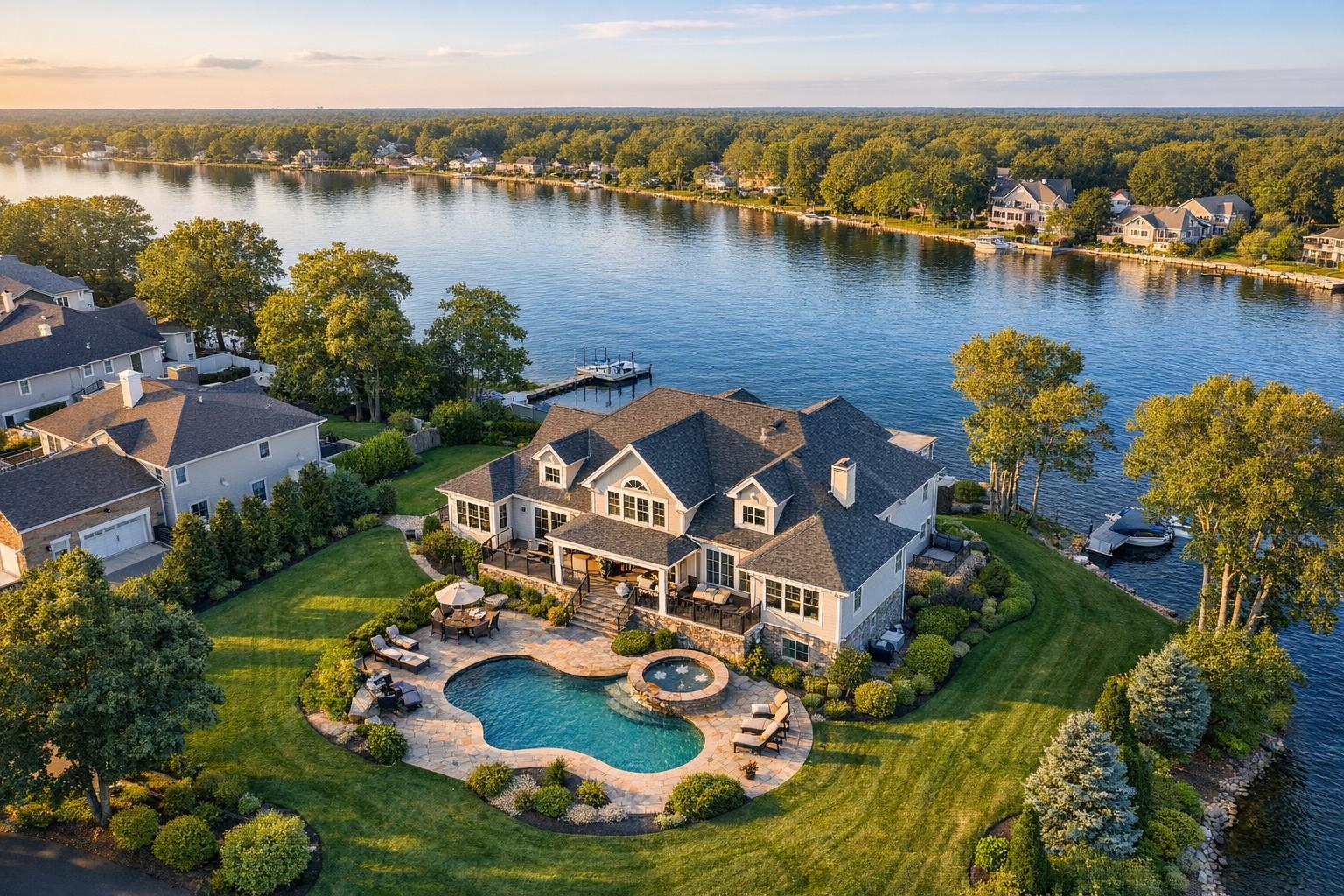
Drone photography in NJ captures a luxurious lakeside property featuring a spacious house, swimming pool, and lush greenery.
Drone Photography NJ: Creating Listing Visuals That Move Buyers
In the competitive tri-state market, leveraging drone photography NJ for real estate marketing can be the difference between a listing that gets noticed and one that’s overlooked. Sellers and agents in New Jersey are turning to advanced real estate drone photography and aerial property photography to create story-driven visuals that captivate buyers the moment they see a new listing. In this article, we’ll unpack why drone real estate imagery is essential for properties statewide, reveal the critical advantages of aerial media, and share expert strategies for selecting a truly qualified drone photographer. You’ll also discover how RealtaSnap delivers compliance, artistry, and regional market expertise, making the process seamless from start to finish.
The Real-World Problem: When Listings Fail to Stand Out
Every NJ seller or agent has faced the challenge: a listing launches, yet online engagement remains flat. Click-through rates stall, and the first impression just isn’t strong enough to motivate buyer action. Photos taken from ground level often miss the full scale, layout, and context of a property—especially in New Jersey, where curb appeal, lot size, water views, and unique rooflines are major selling points.
Here’s what we see repeatedly:
- Interiors look impressive, but the setting—the location, privacy, amenities—are left to the imagination.
- Properties with large lots or multi-unit buildings can appear cramped or misleading in standard images.
- Lighting may be inconsistent, or dramatic landscape features (like swimming pools, gardens, or city skyline views) get lost.
- Listings in competitive areas, from Jersey Shore beachfronts to suburban enclaves, fail to reflect their full value in a crowded field of well-marketed options.
Without drone photography, even well-staged homes can be passed over simply because the visuals don’t tell the whole story or generate the emotional hook buyers need.
What Experienced Media Teams Know: Lessons from Real-World Shoots
Professionals in real estate media and photography know how listing quality rises and falls on visual storytelling. After hundreds of property shoots in NJ and NYC, a few essential operational lessons stand out:
- Drone timetables matter. Wind and weather can limit fly windows—shooting early in the day, or during golden hour, avoids harsh shadows or washed-out skies.
- Prepping the outdoors is as vital as staging rooms. Trimming hedges, clearing driveways, and opening pools before drone arrival means no missed shots.
- Framing for context: A skilled drone operator knows how to position shots to emphasize both the property and its relationship to landmarks, roads, parks, or waterfronts—distinguishing features for New Jersey buyers.
- Balancing exposures: Editing ensures bright, detailed exteriors without losing clarity in shadowed areas—crucial when shooting contrasting rooflines, trees, or mixed urban/suburban lots.
- Safety and compliance: Flying drones isn’t just about artistry; professionals confirm FAA Part 107 certification, check local airspace regulations, and secure roof access in denser areas.
- Selective storytelling: Not every aerial is equal—experienced media teams will combine wide establishing shots, low flybys that reveal landscaping, and close-ups that highlight architectural detail, then sequence them for maximum buyer engagement.
Bottom line: real estate drone photography is not “point-and-shoot.” Results depend on technical precision, regional expertise, and practical workflow know-how honed across hundreds of listings.
How RealtaSnap Solves It: Regional Expertise and Reliable Delivery
RealtaSnap has earned trust from agents and sellers throughout New Jersey and NYC by delivering what matters most: visuals that actually work in-market. Here’s how our approach stands apart:
- Compliance and Professionalism: Every shoot is performed by seasoned, FAA Part 107-certified pilots, with all flights vetted for airspace restrictions, safety, and viability. If a location requires special municipal permits, clients are notified up-front.
- Local Market Mastery: We understand New Jersey’s array of property types—from Hoboken’s brownstones to Monmouth County estates to high-rises facing restricted zones—so we tailor every drone capture to the listing and neighborhood.
- Service Flexibility: Choose the package you need—drone photos, drone video, or our popular combined photo + video options. Each booking includes HDR capture and blue sky replacement as needed, for professional, magazine-worthy results every time.
- Real Turnaround: We know time is of the essence; you’ll receive fully edited, ready-to-publish visual assets quickly so you can stay ahead of buyer demand.
- End-to-End Support: RealtaSnap’s scheduling can be completed online or via our app, and our team keeps you in the loop throughout the process.
Explore service options or see examples at our NYC/NJ drone portfolio: https://www.realtasnap.com/drone-photography-videography-nyc.
Key Benefits of Choosing RealtaSnap Drone Services
- All pilots fully FAA Part 107 certified, with local NJ and NYC expertise
- HDR, blue sky, and exposure-balanced editing for maximum impact
- Flexible booking: photo, video, or combined media packages available
- Quick turnaround—optimized for your next listing’s schedule
- Full compliance with FAA, airspace, and regional property regulations
- Custom aerial perspectives highlight property and neighborhood context
- Professional storytelling: from wide flyovers to intimate detail shots
- Optional add-ons like advanced editing, object removal, and more
- Transparent pricing and service policies (see below)
- Trusted by top agents and leading brokerages in NJ/NYC
Why Drone Photography Matters in the NYC / NJ Market
No region in the country blends property diversity like New York and New Jersey. From dense Jersey City condos to sprawling Bergen County retreats, buyer expectations—and what sells—are shaped by the hyper-visual, digital-first nature of today’s listing platforms.
- Urban vs. Suburban: In cities, aerial property photography helps buyers understand proximity to parks, transit, or skyline views—a major differentiator. In the suburbs, aerials demonstrate lot size, privacy, and unique features like backyard pools, tennis courts, or outdoor entertainment areas.
- Rental Competition: For hosts and property managers listing short-term rentals, drone visuals dramatically increase scroll-stopping power, improving calendar fill rates and nightly values.
- Buyer Imagination: Aerial shots give buyers immediate context, shortening the leap from online search to in-person visit—even for out-of-state or international buyers.
- Platform Behavior: Major portals (Zillow, Realtor.com, Redfin) prioritize listings with rich, engaging media—drone assets often become the gallery’s “hero” image or video.
In these fast-paced, detail-driven markets, missing aerial media often means missing out—buyers move to the next listing in seconds.
Comparison: RealtaSnap vs. Traditional or Lower-Quality Visual Options
- Smartphone or Consumer-Grade Aerials: Even the latest phone cameras can’t capture the context, depth, and dynamic range of dedicated drone equipment flown by experienced pilots.
- Rushed Listing Media: Quick, unplanned shoots often yield generic or poorly-framed images that obscure property strengths or misrepresent scale.
- Inconsistent Editing: Real estate drone photography is only as good as its post-production; without skilled HDR blending and exposure management, skies turn gray and details are lost.
- Delayed or Disorganized Delivery: Time wasted waiting for final files means missed buyer attention and slower sales cycles.
- Generic Service Providers: Non-specialized media teams may overlook the unique local airspace rules, access needs, or daylight conditions that are standard in the NJ/NYC market.
With RealtaSnap, you get a single, accountable team that runs every shoot like it’s their own listing: timed to perfection, tailored to your specific needs, and compliant from first takeoff to final gallery.
Transparent, No-Surprise Pricing
When budgeting for drone photography NJ, you know what you’re getting with RealtaSnap:
- 10 Drone Photos: $209 (1 hour, includes HDR and blue sky replacement)
- Drone Video: $229 (1 hour, 1-minute final 4K video)
- Photo & Video Combo: $299 (1 hour, 10 HDR photos + 1 min 4K video)
All prices and information are subject to change. Information is deemed reliable but not guaranteed.
Optional add-ons (object removal, social cuts, twilight edits, etc.) are clearly listed when you book service. You’ll only pay for what you need, with no hidden fees.
Conclusion: Elevate Your NJ Property Listings with Aerial Media
Today’s buyers have more choices than ever—and seconds to spare when scrolling listings. Drone photography NJ and aerial property photography offer a proven, inspiring way to make your property unforgettable. Whether you’re selling a high-rise condo, listing a suburban retreat, or marketing a short-term rental, RealtaSnap delivers the expertise, compliance, and artistic vision to help your listing shine.
Ready to discover how aerial media can transform your next listing? Explore service options or get started today at https://www.realtasnap.com/drone-photography-videography-nyc or visit our full site: RealtaSnap.com.
Frequently Asked Questions
1. How do I know if my property is eligible for drone photography in NJ?
Many NJ listings can benefit from aerial real estate photography, but eligibility depends on airspace, local restrictions, and property access. RealtaSnap’s team reviews each booking for FAA and local compliance, so you’ll know up-front if a shoot is feasible. If a location isn’t flyable, you won’t be left guessing—our team will suggest alternatives or adjustments to optimize your visuals.
2. What if weather or airspace restrictions prevent my scheduled shoot?
Weather and airspace can occasionally interrupt plans, especially during windy seasons or near high-traffic zones. RealtaSnap proactively monitors conditions and handles all flight authorizations, so if we can’t fly as scheduled, we’ll reschedule promptly or advise another solution—prioritizing your timeline and listing needs.
3. Why choose RealtaSnap instead of a less expensive or generic provider?
Not all drone services are created equal. RealtaSnap combines FAA-certified pilots, regional NJ/NYC market know-how, advanced editing, and support by a dedicated real estate media team. You get visual assets that deliver real value and compliance—making your investment go further and ensuring your listing looks its absolute best every time.