Drone Photography NJ: Elevate Your Real Estate Listings with Aerial Imagery
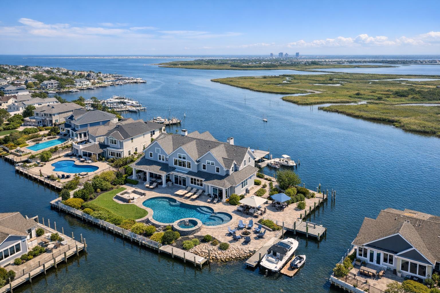
Drone photography in NJ captures a stunning aerial view of waterfront homes with luxurious pools and boats docked along the serene waterways.
Drone Photography NJ: Elevate Your Real Estate Listings with Aerial Insight
Drone photography NJ provides an unmatched vantage point for real estate professionals aiming to convey the full story of a property. When buyers scroll through listings, they’re not just evaluating kitchens and bedroom finishes—they’re trying to visualize where the property fits within its environment. Aerial imagery cuts through the limitations of ground-level photos, delivering instant clarity on setting, scale, and context in a single, powerful frame.
Why Aerial Imagery Is More Than a Trend
Aerial real estate photography is here to stay because it solves a persistent challenge in marketing New Jersey properties: showing not only what a home or commercial site is, but where it is. Whether the listing boasts a spacious yard, sits beside the Jersey Shore, backs up to preserved woodlands, or is steps from a transit stop, the value of context becomes visible from above.
The difference between a property’s story well-told and a listing that leaves questions unanswered is often a matter of perspective. Ground-level images give potential buyers a feel for the interiors and curb appeal. But drone views unfold the entire setting—the proximity to parks, the relationship of outdoor amenities to the main structure, and the all-important connection to the neighborhood, transportation, or shoreline.
Standout Use Cases Across New Jersey
New Jersey’s real estate market is a patchwork of urban, suburban, rural, and waterfront properties. Each location brings unique advantages that can be difficult to capture from the street—but drone angles help bring these defining features to light.
Shore and Waterfront Listings
For properties near the coast, river, or lake, the view is a non-negotiable selling point. A well-composed aerial photo not only shows the property itself, but elegantly places it within the surrounding waterbody or marina. Rather than generic sweeping vistas, the most effective images anchor the home or building in the foreground, leading the viewer’s eye to the shore, dock, or water just beyond.
Suburban Homes with Outdoor Potential
Much of northern and central New Jersey is defined by suburban landscapes—homes with yards, pools, patios, detached structures, or garden spaces that simply can’t be summarized in copy alone. Aerial photography stitches together these elements, giving buyers a practical sense of scale and usability. Larger or irregularly shaped lots, homes with landscaping that visually unites multiple outdoor living areas, and properties bordering open or preserved land all benefit from a higher perspective.
Urban and Transit-Connected Properties
In denser counties and towns, context changes everything. A drone pass can ground a listing by illustrating how close it sits to main streets, commuter lines, parks, or city centers. Careful site assessment is essential; in many urban areas, airspace restrictions, obstacles, and rooftops must be evaluated for flight safety and legality. When possible, even a single aerial shot can serve as a geographic orientation tool buyers appreciate.
Commercial Real Estate and Development Parcels
Commercial listings aren’t just about architecture—they’re about function, logistics, and environment. Aerial real estate photography can make key decision points visually obvious for investors, tenants, or partners: truck access, parking layout, proximity to highways, business hubs, or adjacent developments. Multifamily sites, office buildings, and raw land each require their own best angles, but all benefit when the aerial visuals answer practical questions about access, scale, and neighborhood integration.
Professional Realities: What Goes Into a Successful Drone Shoot
The promise of aerial imagery depends on a blend of planning, property preparation, and operational awareness. Here’s what experienced media teams consider before takeoff:
- Identify the Story, Not Just the View: Effective drone galleries are selective. The most compelling listings don’t overload viewers with repetition, but instead use each angle to accomplish a specific communication goal—be it showing the lot shape, situating the property relative to a notable landmark, or drawing attention to a backyard oasis.
- Exterior Readiness is Crucial: Drone cameras notice everything, from bins and garden hoses to unkempt hedges and cluttered driveways. Making exteriors “camera-ready” ahead of the appointment ensures the final images tell a clean, inviting story.
- Access and Logistics: Properties in managed buildings or communities may require advanced notice for rooftop or yard access. Tenancies, shared spaces, and association rules can affect what a drone operator can safely capture.
- Weather and Airspace: Aerial shoots in New Jersey are governed by FAA Part 107 regulations, and each flight is subject to weather, safety, and pilot assessment on the day. Dense urban airspace might require specific authorizations, and uncooperative weather can delay a scheduled shoot. Flexibility and preparation help ensure a smooth process.
At RealtaSnap, every drone project is evaluated on a case-by-case basis. Some locations, due to airspace or local restrictions, might not be flyable. When permissions are in place, rooftop access can dramatically extend options, especially in urban environments.
Smart Coverage, Thoughtful Sequencing
Aerial media isn’t about quantity—it’s about impact. The strongest drone photography real estate sets tend to include:
- An establishing shot (property in context)
- Elevated exterior views (front, rear, or side)
- Specialty amenity highlights (pools, patios, or lawns)
- Location-based views (showcasing nearby water, parks, or business districts)
- Overhead context for lot shape and surroundings
For a typical suburban home, a sequence might move from a broad establishing view to a focused backyard angle, then hone in on a pool or terrace, ending with a high overview that links the home to nearby features. For commercial real estate, priorities often shift toward showing circulation, parking, loading, adjacent businesses, and transit links.
Drone Imagery Is One Piece of the Listing Puzzle
Aerial context stands out most when it complements other media—interior and exterior photography, floor plans, or even virtual tours. Together, these assets guide buyers from the big picture to the details that matter for their lifestyle or business needs.
For example, interior shots may showcase design upgrades and finishes, while aerial photos clarify the footprint of a large lot or the relationship to major amenities. This coordinated strategy allows buyers to see both the “wow” factor and the practical layout, without overburdening any one type of visual.
Explore more about New Jersey property photography with RealtaSnap’s dedicated NJ real estate photography page.
Booking and Pricing for Drone Services
Setting up an aerial shoot with RealtaSnap is straightforward. Available appointment slots can be viewed in real time with just 24 hours’ notice using the website or mobile app. Clients enter the service address, select from photo, video, or combined drone packages, add relevant details, and confirm the appointment with payment.
Drone packages for real estate marketing in New Jersey are priced as follows:
- 10 HDR drone photos with blue-sky replacement if needed: $209
- One-minute 4K drone video: $229
- Combined photo-and-video package: $299
These options are designed to fit a range of listings, from residential homes to large commercial sites. Still images work well in listing galleries and print materials, while short videos are ideal for property pages and social media. Detailed pricing is always available through the main RealtaSnap website.
What to Know Before Scheduling
A successful drone shoot starts with clear priorities:
- Share your goals up front—whether highlighting a pool, lakefront, parking area, unique roofline, or proximity to a transit stop.
- Remove temporary items from exterior spaces, tidy up landscaping, and ensure all outdoor amenities you wish to feature are ready for the camera.
- If building or rooftop access is required, arrange it in advance to avoid delays.
- Allow flexibility around your preferred appointment—weather, site access, and airspace regulations can occasionally affect the day-of logistics.
Importantly, RealtaSnap’s drone services are strictly for real estate marketing, not for technical inspections, surveys, or architectural analysis.
The Value of Context
Aerial real estate photography is transformative not because it’s flashy, but because it answers questions that matter to buyers and tenants. It visualizes the relationship between property and environment, reveals features that can be missed from the curb, and gives listings a professional, trustworthy presentation.
For sellers, brokers, and property teams across New Jersey—from city centers to suburban streets to waterfront escapes—context often makes all the difference. Professional drone media, paired with ground-based photography and thoughtful coverage, can help deliver the complete picture.
Ready to provide your next listing with aerial context that clarifies, attracts, and inspires? Explore options and book your shoot at www.RealtaSnap.com.
FAQ
Question: Should every listing use drone photography in NJ?
Answer: Not always. Aerial visuals are most effective for properties where the lot, amenities, location, or environment provide meaningful context. Compact homes or sites without distinctive outdoor features may be better served by traditional photography.
Question: Can drone photos in New Jersey capture local landmarks or transport links?
Answer: Yes, when those features are nearby and can be safely included. Well-composed images should always keep the property as the central focus and accurately represent its setting.
Question: What happens if weather or local airspace makes a drone flight impossible?
Answer: Each shoot is subject to real-time assessment of weather, airspace regulations, access, and pilot discretion. If flight isn’t possible on the scheduled day, flexible rescheduling or adjustments ensure only compliant and safe operations move forward.