The Impact of Drone Photography on Real Estate Marketing in New York City
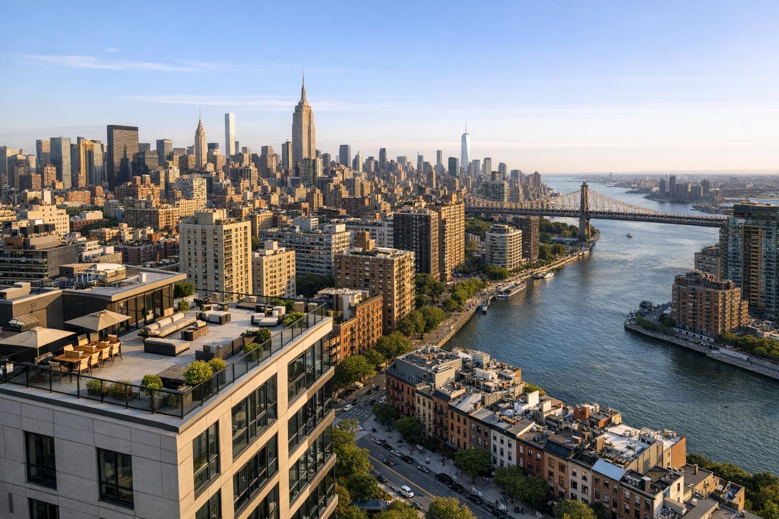
Drone photography captures a stunning aerial view of New York City, showcasing iconic skyscrapers and a sprawling bridge over the river.
Why Drone Photography Is Transforming NYC Real Estate Marketing
Drone photography nyc is rapidly reshaping how real estate professionals capture and present listings across New York City and the greater tri-state area. As buyer attention spans shrink and competition heats up, aerial real estate photography has become essential for making properties stand out on major platforms, driving engagement, and helping agents consistently achieve strong first impressions. In this article, you’ll learn how drone photography real estate services work, what seasoned media teams know from hands-on NYC production, and why partnering with RealtaSnap delivers real results for property marketers.
The Real-World Problem
Agents, property managers, and sellers in NYC face a familiar set of challenges: listings that blend into a crowded marketplace, media that struggles to highlight a property’s most valuable traits, and visual assets that fail to spark buyer imagination. With so many properties hitting the market daily, standard ground-level photography often falls short, especially in Manhattan’s dense urban landscape or the rapidly evolving neighborhoods of Brooklyn, Queens, and northern New Jersey.
Common pain points include weak click-through rates when scrolling past listings, empty spaces that look cold or uninspired, poor lighting that can flatten even designer finishes, and branding that changes from one shoot to the next. Without the right angles, exteriors can appear cramped, amenities get overlooked (think rooftop gardens or communal spaces), and buyers have trouble visualizing flow, scale, or neighborhood context. More than ever, consistently exceptional media isn’t a luxury—it's a necessity.
We've observed that the absence of striking visual storytelling—specifically aerial perspectives—directly impacts both buyer engagement and the perceived value of a home or rental. In a market where each listing is judged in a split second, weak or generic imagery leaves both money and opportunity on the table.
What Experienced Media Teams Know
Seasoned real estate photographers and drone operators understand something fundamental: online buyers are inundated with options and make snap judgments triggered by compelling photos and video. In our work across NYC, New Jersey, and surrounding suburbs, we’ve seen firsthand how the right aerial shot instantly differentiates a property—showcasing its position within the block, revealing access to parks or transit, and creating an emotional pull that’s hard to achieve from the ground.
Before every NYC drone shoot, for instance, we evaluate sun angles for optimal façade lighting—midday often flattens color, while golden-hour can dramatize architecture. We coordinate with building management for roof access and, when necessary, secure flight authorization for compliance since not all airspace is open. During editing, we ensure window exposure is balanced so skyline views aren’t blown out, verticals are corrected, and route wires, HVAC units, or temporary obstacles don’t distract from the narrative.
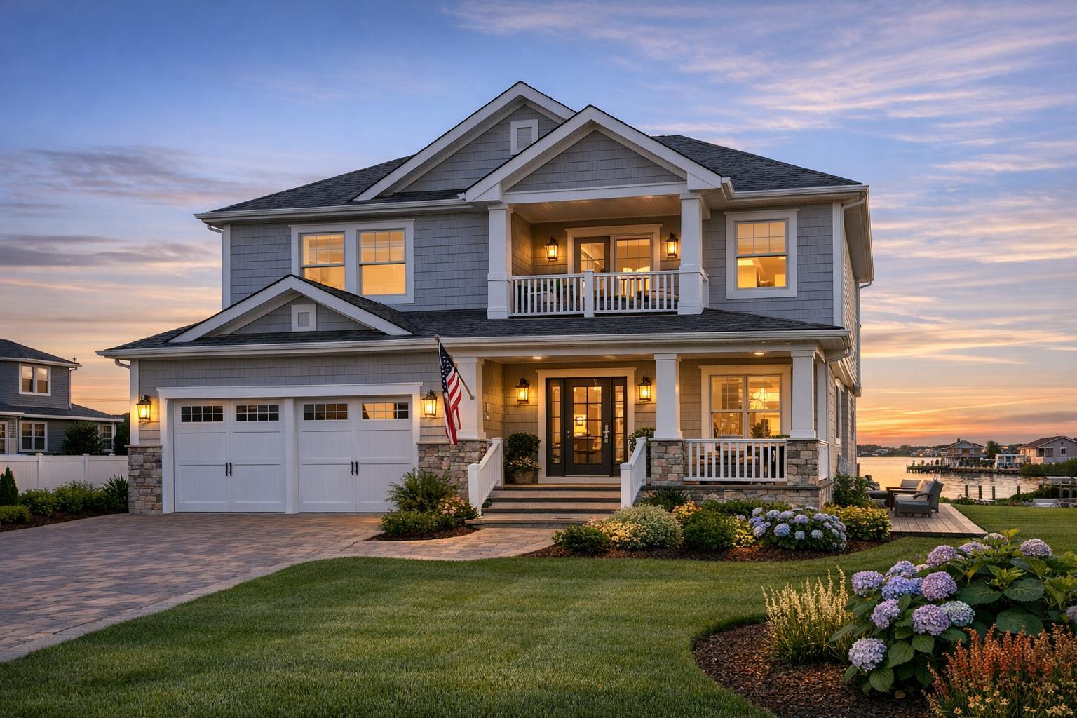
Many listing agents mistakenly think drone imagery is only for large homes or luxury penthouses, but we’ve produced stunning aerials for walk-ups, co-ops, and even rental units—often revealing proximity to green spaces or city icons that ground-level shots simply can’t capture. The difference is clear not just in listing data, but in the new energy and confidence agents bring to each presentation.
Operationally, we know details matter: arriving early to manage weather changes, prepping rooftops or backyards, and ensuring clean sightlines for both vertical and horizontal frames. We’ve learned that consistency—delivering every set with a signature look, prompt turnaround, and flexible scheduling—builds trusted partnerships and elevates brands over time.
How RealtaSnap Solves It
At RealtaSnap, we solve the challenges of drone photography nyc with a focus on quality, reliability, and service tailored for the demands of the NYC and NJ markets. Our licensed drone pilots bring extensive experience in both real estate media and NYC airspace regulations, ensuring every flight is both stunning and fully compliant.
Our workflow is streamlined for real-world speed without sacrificing quality:
- Pre-shoot coordination: We confirm aerial permissions, scout optimal launch sites, and advise on property prep so every session is productive.
- Shoot day precision: We time sessions for ideal natural light and weather, leveraging high-resolution drones calibrated for real estate color profiles and true-to-life verticals.
- Expert editing: Our editors refine each aerial for sky and street balance, correct vertical lines, and merge shots for maximum narrative impact.
- Fast turnaround: Standard aerial photography is delivered within 24 hours—drone video packages are typically ready in 48 hours, even for multi-property volumes.
- Consistent results: Agents receive branded, MLS-ready files with usage support, ensuring every listing is presented at its absolute best.
Pricing is transparent and tailored to project needs. For NYC and NJ listings, our drone photography packages begin at $299, with add-ons for video flyovers or integrated ground/aerial shoots.
All prices and information are subject to change. Information is deemed reliable but not guaranteed .
Our team’s practical experience sets us apart. We know how to prep spaces for maximum impact, direct on-site logistics, and sustain media quality listing after listing. It’s not just about capturing a view; it’s about creating a narrative that drives action—helping you reach more buyers and rent or sell faster.
Ready to elevate your listings in today’s marketplace? See our full range of real estate drone and media services and schedule a shoot designed for busy NYC professionals.
Benefits of Choosing RealtaSnap
- Licensed drone pilots familiar with NYC/NJ aerial regulations
- 24-hour turnaround on standard aerial photo packages
- High-resolution files optimized for MLS, Zillow, and social sharing
- Expert editing for clear verticals and skyline exposure
- Pre-shoot property prep checklists for every booking
- Consistent branded files for portfolio cohesion
- Efficient scheduling—even for last-minute or multi-property shoots
- Integrated media packages (ground, drone, video, 360, floor plans)
- Transparent pricing with no surprise fees
- Responsive, service-driven communication from booking to delivery
Why This Matters in the NYC / NJ Market
New York City and northern New Jersey present unique real estate marketing challenges: dense vertical structures, complex architectural details, and buyers who expect sophisticated visuals. Drone photography delivers critical context—revealing views, access, amenities, and lifestyle features that buyers can’t see from street level. With fierce rental and sales competition, even smaller listings benefit from aerial context, attracting attention away from “just another interior photo” and sparking imagination about location and lifestyle.
Urban buyers want data and emotion—drone media supports both, from panoramic context in Tribeca to lush backyard highlights in Montclair. The trust and polish of professional visuals are non-negotiable in our market, whether you’re a seasoned broker or an independent rental host. Outshining similar listings (even in identical buildings) is possible when your marketing truly elevates the experience.
Comparison with Traditional or Lower-Quality Alternatives
Too often, we see properties marketed with quick phone shots, underexposed interiors, or inconsistent “DIY” drone footage. These shortcuts can create distorted spaces, muddy skies, or even violate city regulations—leading to takedowns and lost buyer confidence. Rushed media may save dollars upfront, but it frequently results in listings that sit for weeks, drive frequent price drops, or force exhausted agents to relaunch multiple times.
In contrast, RealtaSnap’s workflow combines technical skill and an operational playbook built on NYC/NJ realities: vertical correction (for straight lines in tight spaces), window and sky exposure blending, carefully planned composites to mask temporary clutter, and reliable scheduling regardless of weather or location. With consistent branding across every property and responsive, educated support, your listings are primed to attract serious, qualified buyers from the first day.
Our team’s hands-on experience—across co-ops, rentals, penthouses, brownstones, and new developments—means you never have to settle for generic templates or “good enough” images. Your investment in top-tier drone photography real estate services pays dividends in your reputation and client loyalty.
Conclusion & Call to Action
In a marketplace defined by speed, visual sophistication, and razor-thin margins, drone photography nyc isn’t just a trend—it’s a necessity for agents and sellers who want to rise above the noise. With RealtaSnap’s deep local experience, transparent pricing, and operational expertise, your listings earn the attention—and results—they deserve.
Want to see how impactful your next listing could look? Explore our portfolio, real client results, and book your session today with RealtaSnap. We’re here to make your marketing as powerful—and as effortless—as possible.
Frequently Asked Questions
1. Is drone photography legal in every NYC neighborhood?
We often hear concerns about drone restrictions in New York City. While certain areas are subject to airspace rules, RealtaSnap’s pilots handle all compliance, permissions, and flight plans. If a specific location has limits, we’ll suggest creative solutions to capture aerial views safely and legally—making the process stress-free for agents.
2. How quickly will I get my aerial photos and video?
A common hesitation is turnaround time. Most RealtaSnap aerial photo shoots are delivered within 24 hours, with video edits typically ready in 48 hours—even for high-traffic Manhattan or multi-family projects. Our process is optimized for the urgent needs of NYC agents, so you can launch faster and never miss market momentum.
3. What’s included in the drone photography package pricing?
Agents often wonder what’s covered by our drone photography real estate rates. Our standard package includes pre-flight coordination, high-resolution aerial photos, professional editing, and MLS-ready delivery. Add-on options are available for video, 360°, or bundled media at competitive prices—with full transparency and no hidden fees. This means you get stunning visuals and confidence in every project.
For more information, to view featured projects, or to schedule your next shoot, visit RealtaSnap.
All prices and information are subject to change. Information is deemed reliable but not guaranteed.