The Impact of Drone Photography on NYC Real Estate Listings and Market Trends
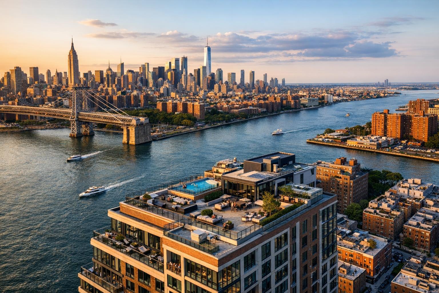
Drone photography captures a stunning view of a high-rise real estate property with a rooftop pool overlooking a river and cityscape, including a bridge and skyscrapers in the background.
Elevating Listings: How Drone Photography for Real Estate is Transforming NYC & NJ Property Marketing
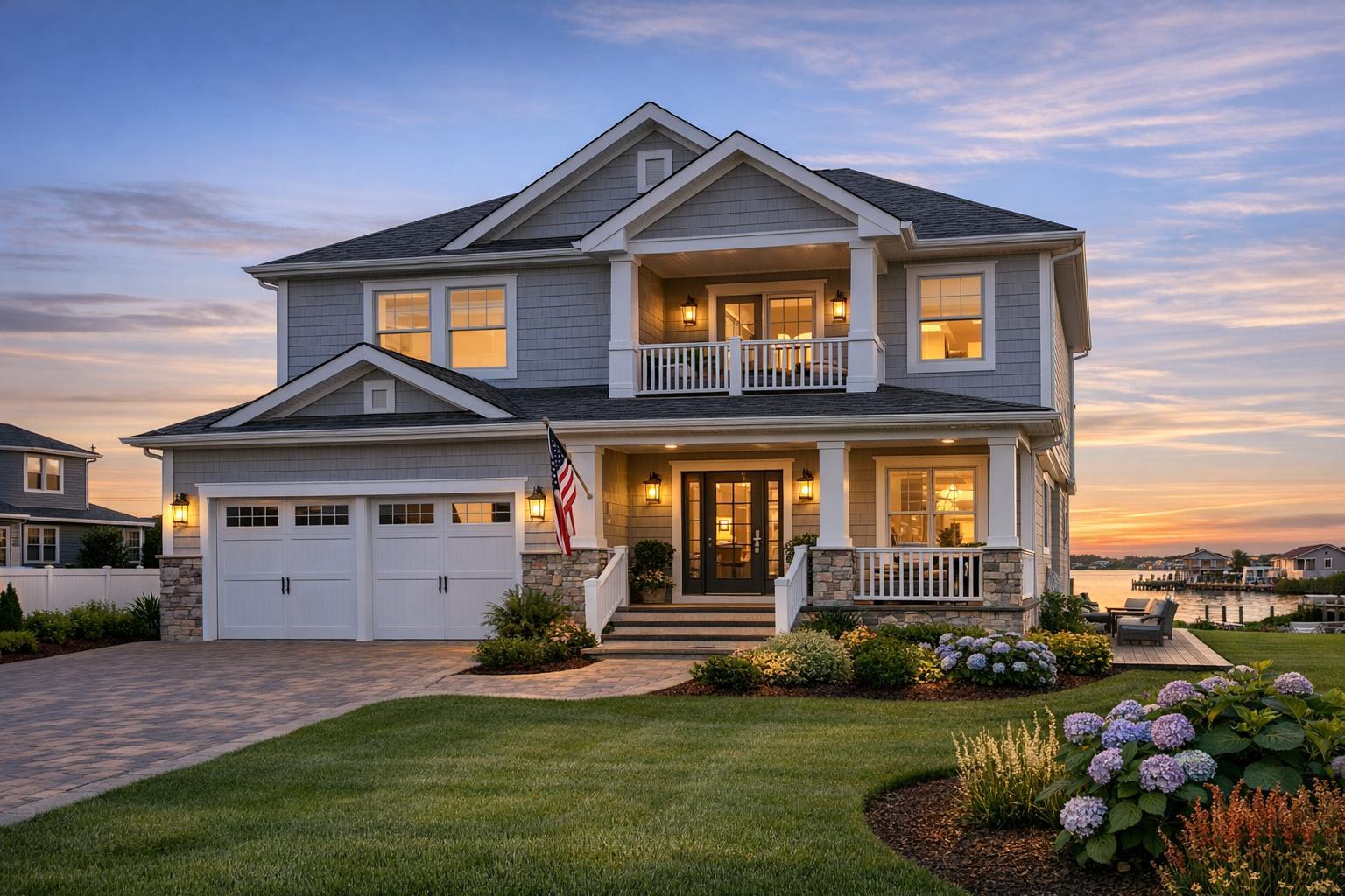
Drone photography for real estate is rapidly redefining what stands out on platforms like StreetEasy, Zillow, and MLS sites—especially in the competitive world of NYC and New Jersey property marketing. Whether you’re listing a Brooklyn brownstone, a Jersey City condo, or a Midtown high-rise, aerial real estate photography now shapes buyer perceptions before they even step through the door. In this post, we’ll uncover how experienced media teams leverage drones to boost visibility, why this approach matters in your local market, and how RealtaSnap streamlines the entire process from scheduling through delivery.
The Real-World Problem: Visibility Gaps & Buyer Hesitation
Every agent, broker, or owner has felt the frustration—an incredible property, but views lag online. What’s the disconnect? Often, traditional photos alone can’t capture unique selling points: expansive outdoor spaces, proximity to parks, rooftop amenities, corner exposure, or that penthouse panorama overlooking Manhattan. Even with interior highlights nailed, listings without compelling exterior visuals risk falling flat.
Common pain points include:
- Low Click-Through Rate: Listings with generic ground-level shots blend in, especially on crowded NYC rental boards or new developments.
- Weak First Impressions: Poor lighting, cramped angles, or obstructions like street traffic can make luxury and entry-level units alike look uninspiring—buying is as emotional as it is logical.
- Spaces Feel Smaller or Less Appealing: Without context, buyers struggle to visualize scale, layout, or how a property relates to its surroundings.
- Missed Location Story: In urban markets, neighborhood perspective—distance to transit, parks, or a skyline view—can make or break urgency.
- Inconsistent Branding: Relying on basic phone photos or pasting together mismatched visuals means properties can look less market-ready than the competition.
- Sluggish Buyer Engagement: Static, ordinary visuals lead to longer days-on-market and more time spent answering repetitive questions that better images could’ve preempted.
If you’ve ever had a listing lag, needed that “wow” factor, or received buyer feedback about unclear layouts or amenities, you already understand the stakes.
What Experienced Media Teams Know: The Process Behind Powerful Aerial Listing Media
Here’s what years in the trenches of NYC real estate media have taught us.
Great drone photography isn’t just about cool angles—it’s about communicating story, scale, and emotion the second someone lands on your listing. But that takes more than buying a drone and pressing record. For starters, timing matters: Aerials captured during late morning or before sunset (the “golden hour”) often deliver the best balance of natural light and shadow, helping rooftops, patios, and pools really pop without harsh glare or blown-out highlights.
Preparation is key. Before any drone flight, the property’s exterior needs to be tidy—trash bins hidden, outdoor furniture straightened, cars positioned to minimize distractions. FAA approval and flight waivers may be required in certain NYC districts and high-density NJ neighborhoods, so working with certified drone pilots helps avoid costly delays. Seasoned real estate photographers focus on vertical correction and horizon leveling so visuals feel immersive and lifelike, not amateur or warped.
In-house editing makes all the difference. It’s not uncommon for raw aerial images to need adjustment: balanced window exposure, subtle sky enhancements, and tweaking shadow detail so white facades or city backgrounds don’t feel flat. If you’re marketing anything from a Hoboken townhouse to a Midtown tower, digital clutter removal or property outlining can highlight what’s actually part of the listing—and avoid confusion for potential buyers.
Workflow must be efficient. High-performing teams prioritize rapid delivery because, in this business, listing momentum matters. That’s why seasoned crews—those who’ve lived through last-minute launches or time-sensitive rentals—schedule, shoot, and post-produce so agents are rarely left waiting.
How RealtaSnap Solves It: Reliable Drone Photography Tailored for Real Estate
At RealtaSnap, we’ve built our entire platform around making aerial real estate photography—sometimes called drone photography NYC—accessible, consistent, and stress-free for agents and property marketers. Here’s how:
Experienced FAA-Certified Pilots:
Our drone operators are licensed, insured, and know the quirks of NYC and New Jersey airspace. That means safer flights, legal compliance, and smoother production days—plus smart choices for framing those priceless river or skyline views.
Streamlined Booking & Scheduling:
Our web and mobile platform lets you schedule a shoot in under three minutes, with real-time team availability. No back-and-forth, no wondering if you’ll miss a weekly MLS update.
Transparent Pricing:
No hidden upgrades, confusing extras, or surprise travel fees. Drone packages start at $209 for 10 aerial photos or $229 for a 1-minute 4K video, with a combo package at $299. Pricing is simple—see all drone services and rates here.
In-House Editing & Fast Turnaround:
Every shoot is processed by our full-time real estate editors—not outsourced. Each file goes through two-step quality control to correct color, ensure level horizons, and create sky replacements if needed. Delivery is within 24 hours—agents are notified automatically and can download, watermark, and share immediately.
Seamless Agent Experience:
Each project comes with a free custom listing website. All media—photos, video, drone aerials, 3D tours—are available in one place for easy sharing with clients or repurposing on MLS, social, and rental platforms.
Key Benefits of Choosing RealtaSnap
- FAA-certified drone pilots with NYC and NJ experience
- 24-hour in-house editing and guaranteed delivery
- Simple, transparent flat-rate pricing—no hidden extras
- Seamless online scheduling from any device
- Free custom property website with every project
- Quality-controlled visuals for MLS, rentals, or luxury listings
Why This Matters in the NYC / NJ Market
New York City, northern New Jersey, and the surrounding metro area are unique beasts. Apartment hunters here expect rich, accurate visuals—just snapping wide rooms and white walls doesn’t cut it. Whether it’s a Prospect Park co-op, a Jersey City new construction, or a Manhattan luxury listing, buyers want to see the full context: skyline exposure, proximity to transit, outdoor spaces, roof decks, and the building’s relationship to surrounding blocks.
Urban and dense suburban listings fight for eyeballs, especially online. With dozens (if not hundreds) of similar options scrolling by, sharp aerial photos and cinematic drone video help properties stand out—accentuating location, scale, amenities, and lifestyle in an instant. These visuals build urgency and transparency, narrowing the buyer pool to those truly interested.
On platforms like StreetEasy and Zillow, listings with polished aerials consistently outperform those relying solely on interiors. Rental units, condos, and new developments especially benefit by giving buyers a sense of context before touring—a virtual curb appeal.
Comparison with Traditional or Lower-Quality Alternatives
Let’s get real—traditional real estate photography (or grabbing quick mobile phone shots) can only do so much. Here’s why serious agents, hosts, and sellers are turning to aerial real estate photography, and how it changes the game compared to lower-quality alternatives:
Phone Photos & Rushed Shoots:
Sure, your phone camera is convenient. But phone sensors struggle with scale and distort perspective outdoors—windows blow out, the sky washes away, and gardens or rooftops get lost. Sudden lighting changes and awkward angles make even the most beautiful properties look average.
Inconsistent Editing & Delayed Delivery:
Some providers outsource editing overseas, leading to unpredictably colored skies or even missing details. If you’re launching a property in days—not weeks—you don’t have time to wait, especially when market windows are tight.
No Clear Exterior Narrative:
Without aerial shots, listings lack context—how does the building relate to its block, is the backyard truly private, or where’s the nearest park located? That’s info buyers and renters expect to see before scheduling a visit.
Generic Providers or One-Size-Fits-All Solutions:
Cookie-cutter approaches often miss what’s special about each NYC or NJ property. Local experience means understanding flight restrictions, knowing which angles matter for Manhattan prewars versus Jersey City condos, or tailoring shots for specific platforms and audiences.
At RealtaSnap, we combine expertise, top-tier tech, and operational precision—so you’re never left with second-guessing or do-overs.
Conclusion & Get Started with RealtaSnap
In today’s property market, powerful visuals make listings stand out and build momentum fast—especially in image-saturated cities like NYC and New Jersey. Aerial real estate photography captures not only the building but the narrative, location, and lifestyle buyers crave. With transparent pricing, streamlined scheduling, fast 24-hour turnaround, and a team that truly knows the ins and outs of city and suburban marketing, RealtaSnap helps you launch with confidence.
Ready to boost your listings with drone photography or want a walk-through of the process? Explore our drone photography and video services here, or schedule your shoot directly at www.realtasnap.com.
All prices and information are subject to change. Information is deemed reliable but not guaranteed.
Frequently Asked Questions
1. Will drone photos really help my listing stand out if I already have great interior shots?
Absolutely. Many buyers scan dozens of listings daily—powerful exterior and aerial images instantly add context your interiors can’t. Drone visuals showcase location, proximity to amenities, and unique features, helping your listing get noticed first. RealtaSnap’s team ensures your property’s best angles are always highlighted.
2. Is drone photography allowed everywhere in NYC and New Jersey?
Drone flights require FAA approval and can be restricted in certain zones, especially near major airports or tight Manhattan corridors. RealtaSnap’s FAA-certified pilots handle all permits, airspace checks, and local compliance so you don’t have to worry. Our team advises on alternatives if aerial capture isn’t permitted at a specific address.
3. How fast can I get my drone photos and video?
With RealtaSnap, you’ll receive fully-edited drone media within 24 hours—delivered through your project dashboard, ready for MLS and all major rental or listing platforms. Fast turnaround is part of our promise, so you never miss a critical listing window.
Curious about aerial real estate photography for your next listing? Reach out any time at www.realtasnap.com—our team is here to help NYC, NJ, and metro-area agents go live faster, with visuals that work as hard as you do.