The Impact of Drone Photography on NYC Property Listings: Insights for Real Estate Professionals
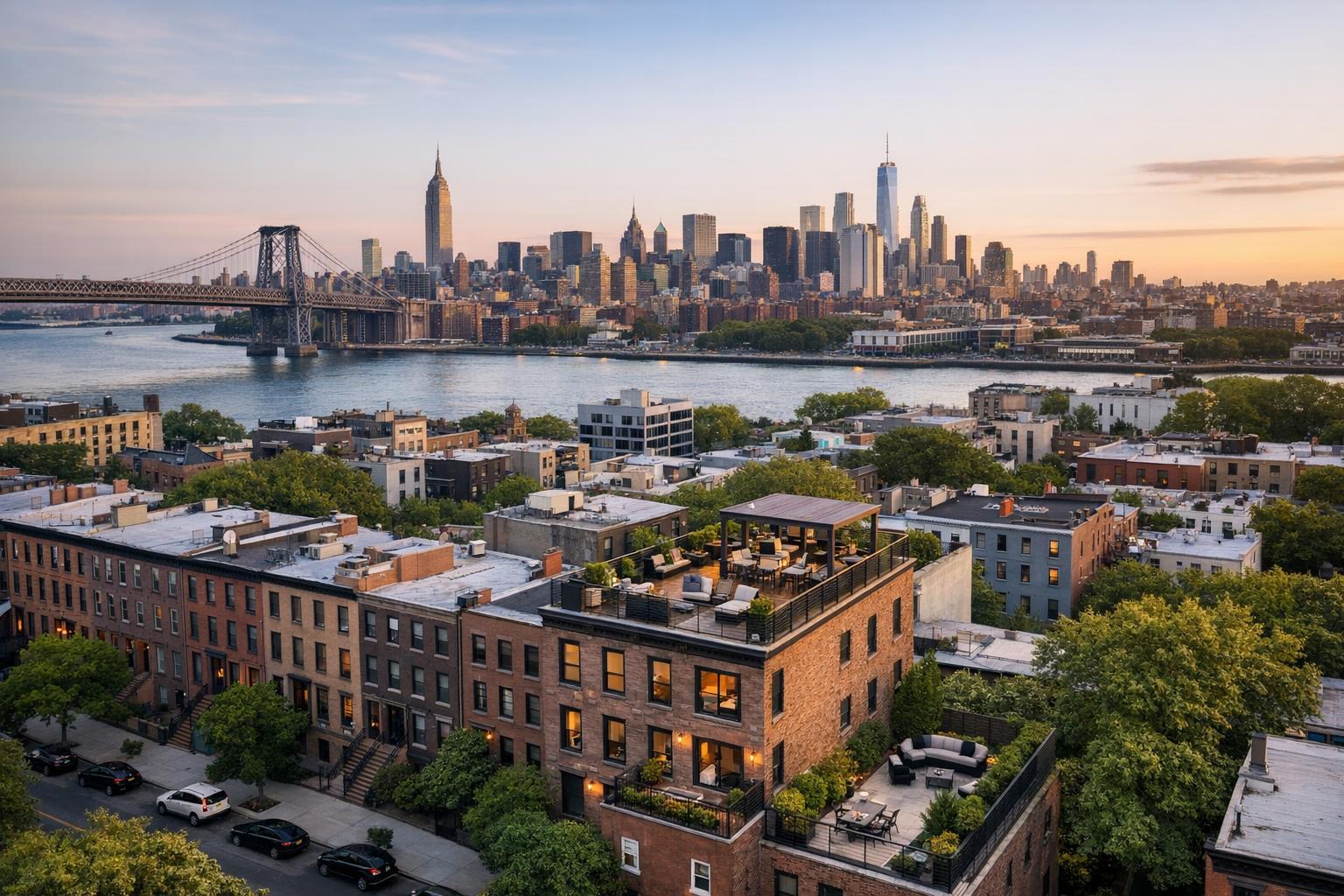
Drone photography captures a stunning view of NYC, showing a vibrant mix of buildings, the iconic skyline, and a bridge at sunset.
Drone Photography NYC: Elevating Real Estate Listings with Next-Level Aerial Imagery
From historic brownstones to new developments, drone photography in NYC has become a powerful differentiator in today’s real estate marketing. If you’ve ever felt that your listings just aren’t capturing the energy or appeal the property deserves, this guide will show you how aerial real estate photography is transforming not only listing performance, but also agent workflow, marketing strategy, and buyer engagement. By the end, you’ll know what sets professional drone photos for real estate apart, how RealtaSnap’s in-house drone team makes the process seamless and safe, and where aerial visuals deliver the highest impact in the city’s competitive property market.
The Real-World Problem: Breaking Through Listing Fatigue and Visual Blindness
No matter how hard you work on your property listing, static images shot from eye level sometimes fail to communicate what makes a home extraordinary. In New York City and New Jersey, where buyers scroll through thousands of options, even a unique listing can disappear in a sea of sameness. Our team has seen this first-hand—media that doesn’t match the reality of a space leads to:
- Low click-through rates as listings blend together
- Weak first impressions that stop prospective buyers from looking deeper
- Media that can’t adequately show location, distinctive roof decks, or building amenities
- Dark window views or unbalanced lighting that obscure cityscapes and skyline appeal
- Empty, cold rooms where staging or angles can’t fully communicate the property flow
- Delayed buyer engagement due to slow media turnaround or inconsistent branding
Agents tell us they want their listings to pop, but quickly find that standard photos, no matter how technically solid, can’t always evoke the full context, feel, or story of NYC living.
What Experienced Media Teams Know: Insights from the Field
Seasoned real estate photographers and aerial specialists know several truths that basic shooters—and listing platforms—often overlook:
- Timing Matters: For New York’s natural lighting, mid-morning to early afternoon gives the best city exposures, while dusk (“blue hour”) drone flights capture the city’s glow without losing detail in the shadows.
- Preparation is Everything: Scouting the rooftop ahead, clearing decks of clutter, and timing shots for minimal pedestrian and street activity can make or break an aerial shoot.
- Balancing Exposure: High-rise locations need careful bracketing and post-production, blending direct sunlight with interior lighting so buyers see real views—without washed out windows or pitch-black interiors.
- Precision and Licensing: FAA-certification for pilots isn’t a buzzword—it’s a necessity for airspace compliance and city-specific flight restrictions, especially around airports, stadiums, and protected locations.
- Workflow Observations: One missed window (especially in Manhattan) can delay a marketing campaign. Professionals have backup dates, weather plans, and image review systems to avoid speed bumps and client surprises.
At RealtaSnap, we’ve found that aerial imagery not only increases engagement but also gives agents tools for social, print, and even site signage—while saving hours on each listing prep. The difference isn’t just the gear, but the expertise behind the lens and the steps we take during staging, shooting, and editing.
How RealtaSnap Solves It: A Process Built for Results
RealtaSnap’s in-house drone team understands what NYC agents face in the field because we work alongside you. Here’s how we make aerial real estate photography painless, predictable, and powerful:
- Trained, FAA-Certified Pilots: Our team only deploys licensed, insured aerial professionals familiar with New York and New Jersey’s regulatory landscape. Every mission is thoroughly planned for legal compliance and neighborhood “no-fly” nuances.
- Lightning-Fast Turnaround: We know when a listing launch can’t wait. That’s why we deliver final, professionally edited drone photos and video within 24 hours of your shoot. No more holding campaigns for late media.
- Transparent, Predictable Pricing: No surprises—our pricing is clear and accessible. For example, our “Drone Photos and Video” package is $275 for up to 16 aerial images and one 30-45 second video, edited and delivered within a day. (All prices and information are subject to change. Information is deemed reliable but not guaranteed.)
- Professional Editing Process: Post-shoot, our editors blend multiple exposures, correct verticals, and enhance clarity—showcasing rooflines, amenities, and sightlines just as you expect them to appear online or in print.
- Effortless Booking: Scheduling takes just a few clicks through the RealtaSnap booking platform, with simple calendar management and instant confirmation.
From iconic city rooftops and water views to brownstone backyards and new construction sites, our workflow is designed for real agents and real property marketing.
Benefits of Aerial Real Estate Photography with RealtaSnap
- FAA-certified pilots for safe, legal aerial media in NYC/NJ
- 24-hour turnaround with professionally edited deliverables
- Transparent pricing and no hidden fees
- Effortless online scheduling and instant booking
- Enhanced property story through unique, dramatic angles
- Seamless integration with listing sites and social
- Consistent, high-quality branding across all your listings
- Full post-production suite—color, exposure, and sky replacement as needed
- Local compliance with flight paths and property access
- Easy add-ons for video, virtual tours, and print
Why This Matters in the NYC / NJ Market
New York City’s luxury penthouses, compact condos, and classic walk-ups all demand visual storytelling that can rise above the block. Here’s why powerful aerial imagery is especially critical in this market:
- Varied Inventory: No two NYC properties are the same; drone footage captures scale, proximity to parks, rooftops, and even tricky lot lines, communicating “location” far better than text.
- Skyline and Amenity Wars: Amenities—like roof decks or private gardens—can be tough to convey from the ground. Top-tier drone shots let buyers imagine themselves living the full urban experience.
- Rental and Sale Competition: With high listing turnover, agents who launch with powerful visuals see less time on market and more showings. Speed, polish, and reliable delivery are real equity in both sales and rentals.
- Platform Demands: Major listing platforms promote engaging visuals higher in results. Professional drone photos are proven to drive clicks and prolonged viewer attention, especially on mobile.
When Agents Should Use Drone Photography: Real-World Examples
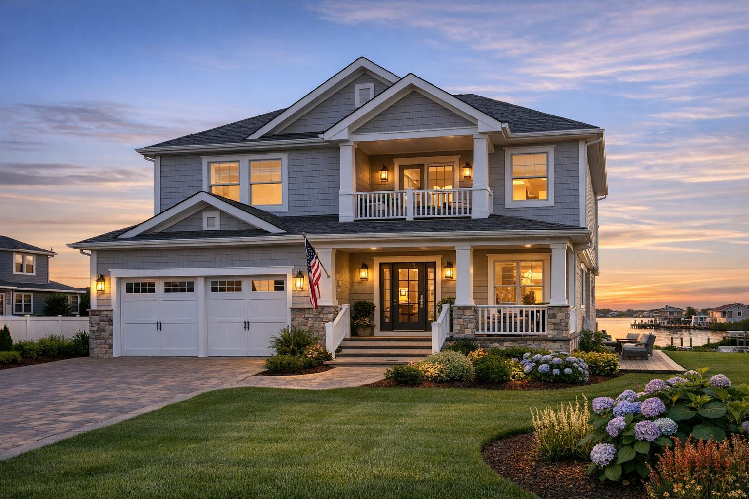
- Rooftop Decks and Terraces: Perfect for Manhattan or Brooklyn listings where outdoor space is a selling point.
- Luxury Brownstones: Capture curb appeal from above to highlight tree-lined blocks or private rear gardens.
- New Developments: Showcase scale, orientation, and progress for investors or off-plan buyers.
- Waterfront Properties: Emphasize short walks to the river, bay, or ocean.
- Condominiums: Demonstrate proximity to transportation, nightlife, or green spaces.
- Unique Architectural Features: Highlight sightlines, corner windows, or sustainable upgrades visible only from the sky.
Comparison With Traditional or Lower-Quality Alternatives
Traditional marketing—think phone snapshots, minimal or DIY drone use, or rushed “one-size-fits-all” edits—often fails to meet NYC’s competitive standards. Agents using outdated visuals face:
- Inconsistent lighting and poor framing, especially with challenging weather or city shadows
- Unedited, “blown out” windows where the view (just blocks from the park!) disappears
- Missed property features—like roof access or backyard terraces—meaning lost value
- Delayed turnaround, resulting in listings waiting days for ready-to-post media
- Staled branding that weakens agent or brokerage reputation
RealtaSnap avoids these pitfalls through tested workflow, reliable scheduling, and media professionals who know that success comes from attention to details and a client-centered process—not just showing up with a drone.
Conclusion: Unlock NYC Real Estate Potential with RealtaSnap
Aerial real estate photography isn’t just for trophy properties anymore—it’s now essential for any agent looking to maximize visibility, compete on first impression, and tell a complete story in the most dynamic property market in the country. RealtaSnap’s in-house drone team delivers the experience, speed, and reliability you demand, without the guesswork or missed opportunities of lesser options.
Ready to elevate your next listing? Explore RealtaSnap’s full lineup of property photography solutions and see how effortless, impactful marketing can transform your business.
Frequently Asked Questions
1. Is drone photography legal and safe in NYC and New Jersey?
Safety and legality come first at RealtaSnap. Every drone mission is conducted by an FAA-certified, insured pilot who understands local airspace rules and has secured necessary permissions for each location. We plan each flight for minimal risk and maximize privacy and compliance. This way, you can focus on marketing, not on worrying about regulations—your property is always in safe, professional hands.
2. How fast can I get my drone images after the shoot?
We know timing is crucial for launching listings or campaign updates. RealtaSnap guarantees professionally edited drone photos and video are delivered within 24 hours of your completed shoot. Even in a busy season, our streamlined process ensures your media is ready for fast turnarounds and urgent launches with no compromise on quality.
3. Are all drone operators at RealtaSnap licensed and insured?
Absolutely—every RealtaSnap drone pilot is FAA Part 107 licensed and fully insured. This isn’t just a formality in the NYC/NJ region; it’s crucial for flying in compliance with complex city regulations and to protect both your property and your brand. With us, every aerial shoot is handled by a credentialed expert.
For more information or to get started, visit RealtaSnap’s official site. All prices and information are subject to change. Information is deemed reliable but not guaranteed.