The Impact of Drone Photography on New York City Real Estate Marketing
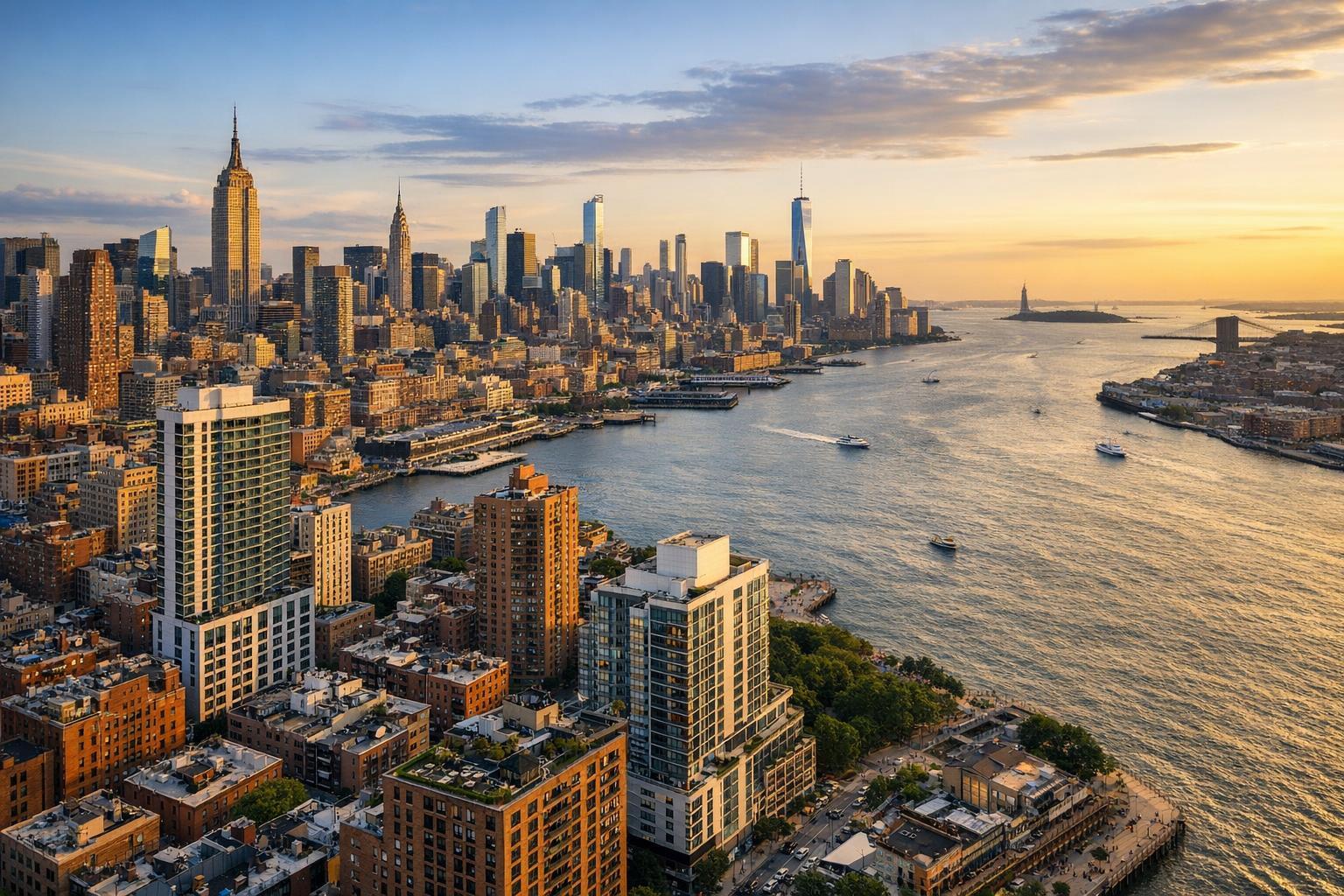
Drone photography captures a stunning view of NYC's skyline and river at sunset, with iconic skyscrapers and the Statue of Liberty visible in the distance.
Drone Photography NYC: Transforming Real Estate Marketing With Aerial Perspectives
Drone photography nyc is reshaping how agents, hosts, and property owners present their listings in one of the world’s most dynamic markets. With advanced real estate aerial photography and expert media strategy, standouts in the NYC and NJ real estate scene are leveraging drone real estate photos and visual storytelling to elevate engagement and property value from the first click. In this article, we’ll break down why aerial drone work is becoming essential, what experienced media teams really do behind the scenes, and how RealtaSnap provides a solution grounded in real-world production and local market insight.
Introduction
In the fast-paced world of New York City real estate, listing presentation makes the difference between a quick showing and a stalled property. Drone photography nyc and captivating drone real estate photos offer a powerful way to capture attention, improve perceived value, and set listings apart—whether you’re marketing a loft in Brooklyn, a suburban New Jersey estate, or a high-rise in Manhattan. Here, you’ll learn how aerial visuals are sparking measurable change in buyer engagement, what experienced property media teams do to get results, and how RealtaSnap makes this advantage accessible and reliable for agents, hosts, brokers, and property owners throughout the region.
The Real-World Problem
Even in the liveliest neighborhoods of New York and New Jersey, listings fall flat without professional, high-impact visuals. Agents and sellers often struggle with low click-through rates, weak first impressions, and buyer disengagement—especially when rooms appear cramped, the lighting isn’t flattering, or the property looks lifeless in photos. Empty spaces, poor window exposure, and media that fails to capture the unique energy or views of a property can leave buyers scrolling past without a second thought.
Many NYC listings compete for attention on major platforms, but generic photos—often shot on phones, rushed, or inconsistently edited—don’t do justice to stunning cityscapes or unique building layouts. Square footage may look awkward, views may be hidden, and exterior appeal goes unnoticed. Even seasoned property managers confess: listings with bland, repetitive media get less traction, slower showing requests, and weaker offers. In a vertical city shaped by perspective, missing the aerial view is missing half the story.
What Experienced Media Teams Know
Those who work daily with photography, video, virtual tours, and real estate aerial photography in NYC and NJ recognize the details that set a listing apart:
- Timing and Lighting: Early morning and late afternoon provide ideal soft light for capturing both exteriors and aerials. Shooting mid-day at tall building sites often causes harsh shadows or blown-out highlights that must be managed expertly.
- Pre-Shoot Prep: It’s not just about the camera. Media teams coordinate with agents for guided walkthroughs, tidying outdoor spaces, opening blinds for view shots, and even staging balconies and rooftops—a detail that matters on Manhattan penthouses or Jersey City condos.
- Aerial Framing and Vertical Line Correction: Experienced operators plan flight paths to showcase skyline angles, outdoor amenities, and neighborhood context. They balance window exposure with interiors, ensure horizons are level, and correct vertical lines so towers and townhomes don’t “lean” in photos.
- Editing Workflow and Delivery: Teams with local experience know fast turnaround is essential (NYC buyers move quickly). Solutions like RealtaSnap offer reliable next-day delivery and consistent color and edit quality, so agents can post, syndicate, and market without bottlenecks or last-minute surprises.
A professional drone shoot isn’t about flashy tech; it’s about visual strategy. The best results come from combining sharp technical skill, local insight, and trusted workflow—from pre-dawn light checks over Riverdale townhouses to balancing the city’s zoning and FAA drone usage regulations.
How RealtaSnap Solves It
RealtaSnap addresses everything that slows down or diminishes NYC real estate listings. Our team manages each aerial project with hands-on attention, deep local knowledge, and thoughtful logistics. We handle FAA compliance, flight planning, and the unique property access challenges in dense city environments. RealtaSnap’s process starts with consultation—interpreting the property’s architecture, setting, and marketing goals—then continues through efficient scheduling, on-site media management, aerial shooting, and careful editing.
By offering specialized real estate aerial photography packages, RealtaSnap empowers agents and owners to show off roof decks, backyards, skyline views, and entire building footprints—making every listing stand out on competitive platforms. Consistent color grading, vertical correction, and fast, on-brand delivery ensure each photo set builds trust and drives engagement.
For most NYC and NJ listings, RealtaSnap provides next-business-day digital delivery, advanced editing options, and secure file access—letting agents move seamlessly from shoot to sale. See the details and booking FAQ at www.realtasnap.com or explore service options for NYC and NJ listings.
Benefits of Choosing RealtaSnap
- Drone photos maximize listing visibility on major platforms
- Skyline and neighborhood context showcase unique selling points
- Fast, next-business-day digital delivery for urgent listings
- FAA-compliant drone operations in NYC, NJ, and suburban markets
- Consistent color, edit, and branding across every photo set
- Hands-on local coordination for smooth property access
- Attention to staging and exterior presentation details
- Flexible packages for residential, commercial, and mixed-use
- Secure, easy online access and file management
- Experienced team with proven NYC/NJ property media results
Why This Matters in the NYC / NJ Market
New York and New Jersey real estate is as diverse as it is competitive. Buyers expect listings to impress instantly—especially in fast-moving rental markets or when high-rise condos, brownstones, or single-family homes all compete for attention online. Aerial perspectives provide crucial context in dense neighborhoods, clarify building amenities, and build confidence for buyers who may submit offers sight unseen.
In cities shaped by vertical and horizontal diversity, real estate aerial photography translates complex property layouts and surrounding views into instantly understandable, scroll-stopping visuals. From Hoboken riverfronts to Brooklyn rooftops, effective drone real estate photos make listings memorable and boost competitive edge, especially when dozens of similar listings are just a click away.
Comparison with Traditional or Lower-Quality Alternatives
Relying on phone photos, rushed agents, or generic providers might seem cost-effective, but it usually leads to:
- Inconsistent lighting and awkward framing
- Missed amenity shots or incomplete exterior coverage
- Skewed verticals (making buildings appear unstable)
- Delayed turnaround—risking lost buyer attention
- Generic edits that miss branding standards
- Compliance risks if unlicensed pilots are used
- Stale listing images that fail to “wow” in crowded markets
In contrast, RealtaSnap is built by experienced real estate media professionals who know what matters: technical reliability, consistent branding, true property representation, and a seamless path from booking to publishing. Whether it’s capturing a Westchester estate’s acreage by air, or a Harlem condo’s rooftop deck at golden hour, the difference is visible and measurable.
Conclusion & Call to Action
In an environment as fast-paced and discerning as the NYC and NJ real estate market, drone photography is no longer just a “nice to have”—it’s become a cornerstone of effective property marketing. With carefully planned aerials, agents and owners can overcome common listing pitfalls, create lasting first impressions, and connect with qualified buyers faster.
The RealtaSnap team brings the experience, compliance, and local understanding needed to excel in this demanding environment—so your properties always look their best, from ground to sky. Ready to give your listings the edge they deserve? Explore how we can help at www.realtasnap.com.
Frequently Asked Questions
1. What if my building has strict drone restrictions or complex access requirements?
Many NYC and NJ buildings have restrictions, but RealtaSnap’s experienced team navigates FAA, local, and property management rules for you. We coordinate directly with doormen, superintendents, and building managers as needed, ensuring compliance and seamless scheduling. If aerials are not possible, we’ll recommend the next-best visual strategy—so your listing always gets quality attention.
2. I’ve seen cheaper options—why invest in professional drone services?
Budget providers or DIY drone photos often overlook vertical correction, lighting balance, and crucial aerial angles, resulting in distorted perspectives and missed details. RealtaSnap’s service includes professional planning, consistent editing, and rapid turnaround, protecting your brand and helping listings stand out in a crowded market.
3. How quickly can I get my final drone photos after the shoot?
We understand NYC and NJ move at breakneck speed—so RealtaSnap delivers edited drone photography, typically by the next business day. This means agents never lose momentum marketing a new property and can respond to buyer interest with fresh, high-impact visuals right away.
All prices and information are subject to change. Information is deemed reliable but not guaranteed.


