The Impact of Drone Photography on New York City Real Estate Marketing Strategies
Drone photography captures a stunning view of NYC's skyline and waterfront at sunset.
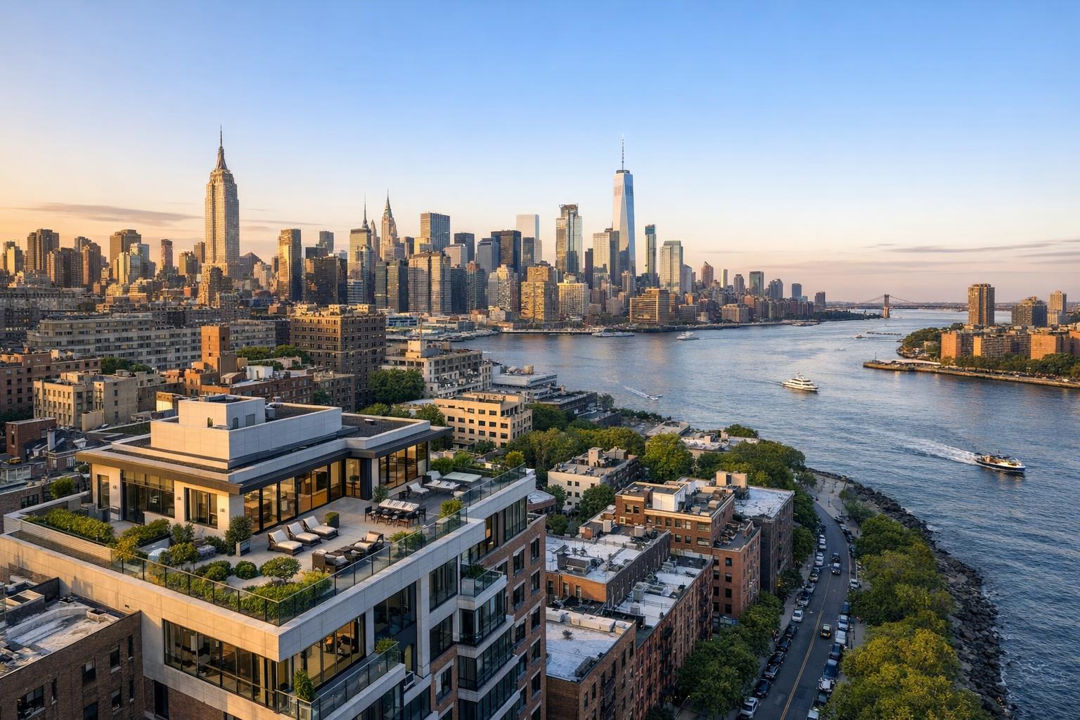
Drone Photography NYC: Elevating Real Estate with Aerial Perspectives That Move the Market
Drone photography NYC is redefining how agents, brokers, and property owners capture buyer imagination and drive engagement on the city’s ever-evolving real estate stage. As property visibility and online presentation become more critical than ever, experienced teams know there's no substitute for high-quality, story-driven visuals crafted with insight and local expertise. In this article, we’ll break down what truly sets NYC drone real estate photos apart, the operational challenges behind creating them, how RealtaSnap transforms those challenges into market-ready advantages, and what this means for your listings—especially in competitive areas like New York City and New Jersey. We’ll also show why real estate aerial photography isn’t just a “nice extra”—it’s often the deciding factor in today’s crowded market.
The Real-World Problem: Marketing Real Estate in Challenging Visual Environments
Every NYC agent, host, or property manager has faced the frustration of a listing that just doesn’t resonate. Maybe the photos look flat; maybe the property seems smaller, darker, or less inviting than it feels in person. You’ve probably fielded calls from sellers asking why their space “looks cold” online, or from buyers confused by low, awkward angles and missing context. Phone photos, inconsistent lighting, and generic shots leave out the vibrancy of a townhouse garden, the openness of a penthouse terrace, or the proximity to iconic city landmarks.
Without well-composed real estate aerial photography, vital features—like a rooftop deck’s cityscape view, the relative size of lots in New Jersey, or even simple curb appeal—often go unseen in listing galleries. This leads to lower click-through rates, fewer buyer inquiries, and longer days on market. In a landscape as visually competitive as the NYC metro area, relying solely on ground-level images can make standout properties blend in—and two-dimensional galleries can limit buyer imagination and emotional connection.
Some of the most common issues we see as seasoned real estate media professionals include:
- Properties photographed at the wrong time of day, with uneven shadows or blown-out windows.
- Spaces that appear smaller or more cramped due to incorrect lens choice or poor framing.
- Loss of unique architectural lines because of rushed editing, imbalanced verticals, or missed sight lines.
- Inconsistent branding between listing visuals, virtual tours, and marketing collateral, which can weaken agent reputation and confuse buyers.
If you’ve ever spent more time explaining what makes a property special than showing it, you’ve felt the consequences of underwhelming real estate photography.
What Experienced Media Teams Know
Years behind the camera in the NYC and NJ markets have taught us that every detail—lighting, timing, staging, shot selection—shapes buyer emotion and action. True pros know:
- Timing is critical: For drone shoots, we carefully coordinate window lighting and weather to avoid harsh midday sun, which can flatten the scene and hide key outdoor features. Twilight sessions often draw more online attention, capturing both city lights and property ambiance.
- Site preparation matters: Before arriving, we send agents and sellers a checklist that covers everything from securing rooftops and terraces to clearing parking lots and driveways. A single trash bin in an aerial shot can distract from a million-dollar view.
- Framing and perspective change everything: Drone pilots with real-world listing experience know how to capture visual storylines—showing not just the roof, but the relationship of the building to the skyline, park proximity, or a water view.
- Post-production is as important as capture: Raw aerial images almost always require color balancing, horizon correction, and exposure blending to match ground-level interiors and convey cohesive brand quality throughout the listing gallery.
Real estate aerial photography isn’t just about flying a drone and clicking a button. It’s about predicting what will stop a buyer’s scroll, what will build instant trust, and what will get them booking a showing. In competitive city boroughs and quick-moving New Jersey suburbs, these professional refinements are the difference between a listing that gets overlooked and one that draws a line out the door.
How RealtaSnap Solves It
At RealtaSnap, our philosophy is simple: build every shoot around the needs of real-world agents and the unique selling points of each space. Our team’s field-tested process starts long before the drone takes off:
- Pre-Shoot Consultation: We review the property, discuss your marketing goals, and advise on timing, staging, and key features to highlight—whether that’s an Upper West Side rooftop, a Jersey City community pool, or a Brooklyn brownstone’s backyard.
- Expert Capture: FAA-certified drone pilots, backed by years of NYC-specific experience, choose the right flight paths, altitudes, and angles to maximize perspective while maintaining safety and privacy compliance.
- Visual Consistency: We apply advanced editing workflows that preserve true window views, correct verticals, and match exterior shots with interior gallery style—creating a story that feels compelling and complete.
- Fast, Predictable Turnaround: In most cases, clients receive their edited images and videos within 24 hours of the shoot—making it easy to beat the market and launch a listing without delay.
- Seamless Online Delivery: Media is delivered via a secure portal, with gallery links optimized for MLS, social, and custom agent sites—streamlining sharing and syndication for maximum reach.
Our commitment to practical, hands-on operational details is why so many agents in NYC and New Jersey rely on RealtaSnap to elevate their properties. You’ll see the difference in every frame—from the way we frame signature city views to the polish of every final edit.
Benefits of Choosing RealtaSnap
- FAA-certified pilots familiar with NYC/NJ airspace.
- Consistent color and branding across all media.
- Advanced editing for true-to-life window and sky balance.
- 24-hour turnaround for most listings.
- Pre-shoot checklists for maximum property readiness.
- Full suite: drone, photo, video, and virtual tour services.
- Secure online delivery with MLS-ready formatting.
- Highlighted key features and amenities that matter to buyers.
- Updated workflows to reflect changing listing platform rules.
- Reliable communication with agents and property managers.
Why This Matters in the NYC / NJ Market
The stakes are different in our region. New York City listings compete not just for local buyers, but for attention from across the globe. Spaces are diverse—a Harlem townhouse, a Hoboken condo, and a Midtown high-rise all demand tailored approaches. Rental markets are hyper-active, listings can turn over in days, and buyers expect transparency and a sense of place from every visual touchpoint.
In urban settings, drone photography is often the only way to capture a property’s context—showing building amenities, nearby parks, cityscape proximity, or unique lot position, all in a single, sweeping frame. In New Jersey, where sprawling lots, pools, and suburban gardens are selling points, only real estate aerial photography shows true scale and separation from neighbors.
MLS platforms, Zillow, and StreetEasy increasingly prioritize listings with immersive, varied imagery. With so many options and limited buyer attention spans, engaging visuals—especially aerial or NYC drone real estate photos—are often the first reason a buyer clicks “Schedule Tour.”
Comparison With Traditional or Lower-Quality Alternatives
Relying on phone snapshots, hurried ground photos, or basic out-of-the-box drone work carries risks. Overexposed windows, lopsided horizons, and bland compositions cause listings to underperform, while missing aerial shots means failing to showcase location, scale, or outdoor features—a major selling point in the NYC/NJ market.
Often, agents tell us they’ve tried generic providers in the past and were disappointed by:
- Delayed delivery—sometimes five days or more, missing the critical launch window.
- Inconsistent color grading, making exteriors look washed out or interiors look yellowed next to aerial shots.
- Missed details—garden upgrades, rooftop amenities, or proximity to key landmarks—left out of the final gallery.
- No aerial options at all, meaning luxury or special properties look just as generic as mid-market units.
RealtaSnap’s focus on hands-on, region-specific media creation and editing solves these issues, helping every property look its best, launch faster, and reach more engaged buyers—every time.
Conclusion & Call to Action
In today’s market, drone photography NYC isn’t just a trend—it’s an essential strategy for capturing buyer interest, making listings stand out, and maximizing your client’s first impression. When you work with an experienced team like RealtaSnap, you gain more than images; you gain a trusted ally who knows what it takes to tell your property’s story and drive real results under real market conditions.
If you’re ready to see your listings rise above the competition with professional real estate aerial photography and NYC drone real estate photos, visit RealtaSnap to learn more or book your next shoot. We invite you to discover how powerful visual strategy meets hands-on expertise—right where you need it most.
To explore our full menu of services, including detailed information on drone, video, and virtual tour packages, check out our Real Estate Media Services page.
Frequently Asked Questions
1. Will drone photography add a lot to my listing costs?
We understand that every dollar counts. RealtaSnap’s aerial photography packages are thoughtfully priced to provide maximum value, and you’ll see all rates clearly before booking. Most agents find that a small investment in stunning drone visuals drives exponentially more clicks and inquiries. All prices and information are subject to change. Information is deemed reliable but not guaranteed.
2. Are there restrictions or delays when flying drones in NYC or NJ?
Certain neighborhoods and properties do have airspace restrictions. Our FAA-certified pilots have extensive experience navigating these rules in both NYC and New Jersey. We plan every shoot in advance and communicate about permissions early, so you’re never caught off guard. Trust that if it can be done, we’ll make it happen—timely, safely, and legally.
3. How quickly will I receive my drone photos and videos?
We know the market moves fast. RealtaSnap guarantees a 24-hour turnaround for most standard shoots. You get MLS-ready images quickly, so you can launch or update your listings without delay. Our process is built to keep you ahead of the competition—every time.


