The Impact of Drone Photography on New York City Real Estate Marketing
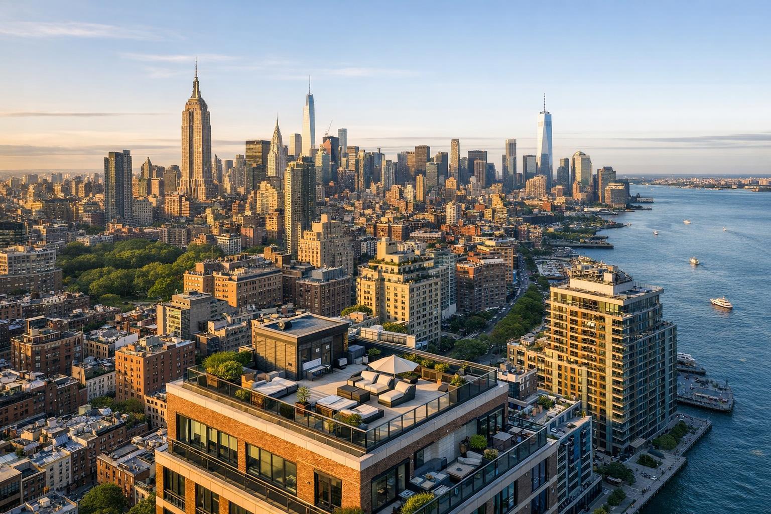
Drone photography reveals a sweeping view of a city's skyline, highlighting the diverse architecture and prime real estate along the waterfront.
Drone Photography Real Estate: Elevating NYC Listings with Aerial Imagery
Drone photography real estate is quietly revolutionizing how properties stand out on New York City’s crowded digital stage, and it’s changing the math on what real estate photography NYC professionals can expect from their marketing investments. In this article, you’ll uncover how aerial real estate photography delivers visible benefits for NYC, New Jersey, and suburban listings, see precisely why buyer engagement improves with this approach, and learn insider best practices for using drone media the right way. You’ll also discover why collaborating with a specialized company like RealtaSnap ensures professional, consistent, and compliant results—every time.
The Real-World Problem
Put yourself in the shoes of an NYC or New Jersey agent (or maybe you’re already there): You’ve got a great listing, but the photos just don’t pop. Standard exteriors flatten out—brownstones look like every other facade, rooftop decks get lost, and backyards are hard to appreciate from street level. Traditional shots make it difficult to tell how a property relates to its neighborhood or unique features, especially in the city’s vertical sprawl or suburban spread. On popular platforms like StreetEasy, Zillow, and the MLS, first impressions last milliseconds; if your opening frame is yet another compressed, slightly crooked shot of a front door, buyers scroll past.
Other all-too-common problems:
- Click-through rates stagnate because listings all blend together.
- Shadowy exteriors and blown-out windows make the space look uninviting.
- Outdoor amenities—think pools, gardens, skyline terraces—are nearly invisible from ground-level photography.
- Empty or strangely cropped shots leave buyers piecing together the layout in their heads, rather than experiencing the property’s true flow.
- Inconsistently branded media makes your portfolio look like a patchwork of styles.
- Renters—particularly in the ultra-competitive NYC and NJ condo markets—are left guessing about proximity to parks, schools, and transit.
In short: Standard listing photos often fail to sell the experience, let alone clinch the click.
What Experienced Media Teams Know
Having spent years producing real estate photography, video, and aerial imagery for brokers, developers, and hosts across the city and suburbs, we’ve seen firsthand what separates outstanding listings from forgettable ones.
- Buyers are visual learners. They want to see where a unit sits within a building, how a backyard scales, or what a penthouse’s roof terrace overlooks. Aerial and drone imagery accelerates orientation, helping buyers imagine life there before stepping through the door.
- Light and weather timing are everything. We plan shoots around sun angles and golden hour, using drones to capture soft, even light on facades rather than midday glare or long winter shadows. In the city, timing the traffic (and double-parked vans out front) is as vital as balancing interiors for window exposure.
- Proper preparation pays off. We always walk the property’s perimeter first, mapping safe drone takeoff spots and reviewing the flight path to avoid security cameras, pedestrian zones, or construction scaffolding common in NYC and Hoboken.
- Workflow matters. Raw drone footage needs more than an upload. Our pros carefully correct vertical lines, adjust for lens distortion, color grade for natural greens and blues, and sequence shots to tell the property’s story—often showing the approach, the lot, and transitions into main living spaces. Each asset is tailored for the platforms where buyers actually start their search.
- Compliance is non-negotiable. Using drones legally in NYC means respecting strict FAA, city, and building association rules, including no-fly zones, altitude limits, and privacy protocols—a risk that DIY providers or general contractors often miss entirely.
True expertise means knowing there’s no “one size fits all” approach—every property, block, and season presents new visual and logistical challenges.
How RealtaSnap Solves It
At RealtaSnap, we’ve built our workflow around the realities of the NYC and NJ market. Our team combines drone-certified pilots, experienced real estate photographers, and skilled editors—all with a deep understanding of local property types and listing standards. Here’s how we handle aerial real estate photography from start to finish:
- Pre-Shoot Consultation: We evaluate the property’s distinct selling points and determine if, when, and how drone imagery adds value, always mindful of local restrictions.
- On-Site Execution: Our media specialists secure necessary clearances and insurance, arrive with professional drone gear, monitor conditions, and follow a shot list that highlights features buyers care about—like private yards, skyline views, and neighborhood context. We also coordinate interior shots for seamless branding and natural light.
- Professional Editing: Every image is color-graded and straightened (verticals matter especially on tall buildings), with sky replacements or dusk blends available as needed.
- Fast Turnarounds: Most NYC and NJ listings go live within 24–48 hours of the shoot, with all final media optimized for the MLS, brokerage sites, and social platforms.
- Consistent Branding: You get a unified look—no matter how many listings you have, your portfolio looks sharp and deliberate.
- Regulation-First Mindset: All drone flights are FAA compliant, insured, and logged, protecting you and your seller from potential liabilities unique to NYC airspace.
Whether it’s a Tribeca loft, Jersey City townhome, or a suburban Colonial, we treat every property as a new visual story, ensuring the final listing media isn’t just beautiful, but strategic.
Benefits of Choosing RealtaSnap
- Drone pilots FAA-certified and NYC-experienced
- Lightning-fast 24–48 hour turnaround
- Consistent, on-brand media for all your listings
- Clear, wide-angle aerials showcase true property scale
- Custom shot lists to highlight unique features
- Professional editing—no harsh shadows or blown-out windows
- MLS-optimized formats and file sizing
- Fully insured operations for client peace of mind
- Guidance on compliance and neighborhood-specific rules
- Enhanced visual storytelling for discerning NYC/NJ buyers
Why This Matters in the NYC / NJ Market
Properties in New York City, New Jersey, and neighboring markets face fierce competition. In Manhattan, even the most striking penthouse can get lost among dozens of similar units unless the visuals stand out. Suburban homes must advertise not just interior finishes, but yards, outdoor living, and neighborhood amenities—often best experienced from above. In areas like Hoboken or Astoria, proximity to parks or waterfronts can swing rental or purchase decisions; aerial imagery lets buyers and tenants instantly see the context. On listing platforms where attention spans are short, visually dynamic aerial shots draw the eye—and keep it.
In addition, tight timelines and busy seller schedules mean branding and speed can’t be afterthoughts. RealtaSnap’s integrated workflow is built for agents and managers who need to go live on schedule, without wrestling with unpredictable freelancers or city permit headaches.
Comparison with Traditional or Lower-Quality Alternatives
We’ve seen it plenty: Cell phone “drones” held out the window, or poorly framed shots that exaggerate yard size or distort building proportions. Rushed or inexperienced media leads to dark exteriors, tilted horizon lines, and post-shoot “fixes” that don’t solve the root issue—a lack of professional vision. Standard street-level photos, taken quickly by a friend or property manager, rarely capture how a home truly sits in its neighborhood or what makes it unique in a vertical city like New York.
Even high-end ground photography alone can’t create the sense of arrival, scale, or connectivity that good drone work delivers. Throw in a missed turnaround or a non-compliant flight over restricted airspace, and you risk both your reputation and your seller’s trust.
Conclusion & Call to Action
Drone photography real estate is not a passing trend—it’s a genuine upgrade to property marketing across New York City, New Jersey, and beyond. By leveraging tailored aerial visuals, real estate professionals can showcase features, neighborhoods, and amenities that otherwise go unnoticed. If you’re ready to make your next listing stand out—and stay compliant—RealtaSnap is ready to help you capture every angle. Explore our full portfolio and book your next shoot with confidence at www.realtasnap.com. For agents and brokers looking to elevate their listings with premium photography, videography, and drone services, see our real estate photography solutions for the NYC/NJ area.
Frequently Asked Questions
1. Is drone photography really allowed for real estate in New York City?
Many agents worry about flying drones in NYC due to strict airspace and city rules. RealtaSnap navigates these regulations by using FAA-certified pilots and securing necessary clearances. Our trusted process ensures all flights are legal and compliant, removing the headache from the agent experience.
2. What if my property doesn’t have obvious outdoor features—does drone photography still help?
Aerial imagery isn’t just for big backyards or rooftops. Drone shots can reveal neighborhood context, show building scale, and highlight features like proximity to transit, parks, or unique architecture. Even compact urban spaces can benefit from professional drone visuals handled by the RealtaSnap team.
3. How quickly will I receive my edited drone photos and videos after the shoot?
Turnaround time is a huge concern, especially in NYC’s fast-paced market. RealtaSnap delivers finalized and MLS-ready drone photography—along with ground and interior images—typically within 24–48 hours. This means you can activate your marketing plan and attract buyers without delays.
All prices and information are subject to change. Information is deemed reliable but not guaranteed.


