The Impact of Drone Photography on New Jersey Real Estate Listings
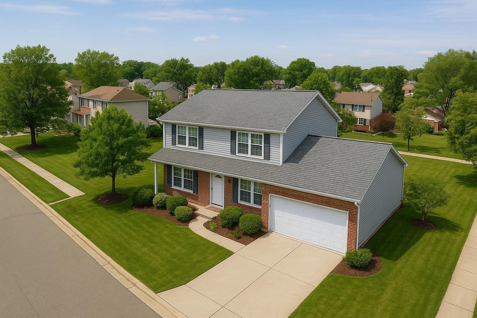
Captured through drone photography in NJ, the image shows a suburban neighborhood with neatly manicured lawns and a two-story house.
The Impact of Drone Photography in NJ Real Estate Marketing: Elevating Listings with Aerial Perspective
Drone photography NJ is transforming the way real estate professionals market properties in a fast-evolving, competitive local landscape. In this article, you’ll learn how aerial real estate photography creates a compelling first impression, the challenges that drone services solve for agents and sellers, how to choose the right drone real estate photographer, the importance of regulations, and why NJ’s market landscape makes high-quality drone shots especially valuable. We will also share insider details from the field—straight from a team with hands-on experience in real estate photo and video production in New Jersey and the NYC metro area—so you understand both the art and science of drone photography for real estate.
The Real-World Problem
New Jersey’s real estate market is intense and crowded, with agents and sellers often relying on the same tired angles—ground-level photos that struggle to capture the full story of a property. Without aerial perspectives, listings tend to fall prey to problems like:
- Low click-through rates, because thumbnail images look generic.
- Weak first impressions—buyers swipe past photos that don’t stand out in their feed.
- Properties with acreage, pools, proximity to parks or water, or unique layouts look flat or misleading.
- Inconsistent lighting, blown highlights in sunny backyards, or crooked vertical lines from rushed phone shots.
- Listings for multifamily, condos, or new builds don’t convey context—potential buyers can’t visualize placement, parking, or nearby amenities.
- Homes near major roads or featuring large lots miss the big-picture impact of their setting.
- Dull and empty spaces that fail to spark the imagination of buyers browsing from afar.
- Unreliable branding—agents working with different photographers or DIY media end up with listings that lack a cohesive look.
- Slow engagement and more time on market, especially when the property’s strengths (proximity to highways, water views, or landscaped yards) aren’t featured in opening shots.
For agents and hosts relying solely on traditional photography, these pitfalls make it hard to get traction quickly—leading to long days on market and properties perceived as less valuable.
What Experienced Media Teams Know
When you’ve photographed, filmed, and staged hundreds of listings across New Jersey and NYC, you learn what truly sets a property apart online. Here’s what we know from real production experience:
- Lighting is everything. The best aerials are captured close to golden hour when sunlight is soft, but timing must align with property orientation, weather, and pilot availability.
- Prepping the exterior matters. Simple details—like moving cars from the driveway, removing garbage cans, and coordinating with landscapers—ensure a clean, inviting perspective from above.
- Correcting perspective in post-production is crucial. Straight verticals and balanced window exposures make drone photos look polished and professional.
- Safety and legality are non-negotiable. Pilots must assess local FAA regulations, check for controlled airspace (near Newark, Teterboro, or Trenton), and sometimes secure roof access for better flight paths around urban and suburban properties【20:6†RealtaSnap_Service_Execution_Policy_MASTER.docx】.
- A workflow built for agents’ real schedules. Successful media teams understand agents are under pressure to launch and turn around listings fast—final edited aerials need to be delivered within 24-48 hours, not a week later, to stay competitive【20:0†RealtaSnap_Rate_Sheet_MASTER.docx】.
- Brand consistency drives recognition. Whether it’s a signature blue sky replacement or consistent framing style, the little production details reinforce the agent brand across every listing.
How RealtaSnap Solves It
At RealtaSnap, we’ve built our drone photography and videography services to address these very problems—streamlining the entire process for agents, property managers, developers, and sellers across New Jersey.
Our aerial photo and video packages include:
- Careful planning and compliance: We research airspace issues, obtain necessary authorizations, and communicate up front about safety, local restrictions, and feasibility.
- Professional-grade equipment: Our drones shoot in high-resolution HDR and 4K, capturing broad property overviews and dramatic approach shots that bring listings to life.
- Clean, guided production: We coordinate with agents on prepping exteriors and schedule shoots with just 24 hours’ notice, so you never miss a critical listing window.
- Visual polish and editing: Every drone photo is expertly color-graded, with perspective and verticals corrected for slick, magazine-quality presentation. Blue sky replacement is included for those cloudy Jersey days.
- Fast, reliable delivery: You get fully edited images ready for MLS, social, or premium platforms within 24-48 hours, including both print-ready and web-optimized formats【20:0†RealtaSnap_Rate_Sheet_MASTER.docx】.
View our full drone photography and videography packages here.
All drone operations meet FAA Part 107 standards, and we offer clear guidance on what’s possible in every corner of NJ, from the waterfront communities of Hoboken and Jersey City to suburban estates and new residential developments.
Benefits of Choosing RealtaSnap
- Fast 24-48 hour photo delivery, even for drone shoots
- Precise HDR and 4K images with vertical and horizontal correction
- Full FAA Part 107 compliance for safe, legal flights
- Blue sky replacement included for consistent branding
- Reliable scheduling with only 24 hours’ notice, even in busy season
- New Jersey statewide coverage—urban, suburban, or waterfront
- No-nonsense pricing: 10 drone photos for $209, video for $229, or combo for $299
_All prices and information are subject to change. Information is deemed reliable but not guaranteed._【20:2†RealtaSnap_Rate_Sheet_MASTER.docx】 - Easy MLS, print, and social-media-ready deliverables
- Pre-shoot coordination to ensure cars, trash cans, and distractions are moved
- No need for agents to wrangle remote pilots or chase deliverables
Why This Matters in the NYC / NJ Market
In New Jersey and the greater NYC region, property listings compete for attention not just with local neighbors, but with hundreds of similar spaces nearby. Two key trends make drone photography especially high-impact in this market:
- Smaller urban lots, vertical condos, walk-ups, and new developments need aerial perspective to show context—proximity to mass transit, parks, and lifestyle amenities.
- Buyers are often remote (for example, corporate relocation, Manhattan residents seeking more space, or out-of-state investors) and rely on online media to decide what’s worth a physical visit.
- Rental and sales markets move fast, and split-second buyer impressions on Zillow, Realtor, and StreetEasy are driven by thumbnail image quality.
- Suburban listings with acreage, pool, or extensive landscaping look smaller and less desirable in standard photos. Aerial images make big lots and unique architecture shine, making listings memorable and clickable.
High-quality aerial images in NJ listings often mean the difference between being one of five “saved” properties in a scrolling session—and being the one that gets visited first.
Comparison with Traditional or Lower-Quality Alternatives
Agents sometimes ask why professional aerial photography is worth the investment when a quick phone photo or amateur drone operator seems “good enough.” Here’s what happens in the field:
- Phone-level drone or rushed aerial shots: These often show jagged rooflines, blown-out sky, and uneven exposure. Irregular shadows, harsh lighting, and incorrect verticals make properties look uninviting, not high-value.
- Non-compliant or uninsured drone work: Agents risk fines, cancelled flights, and incomplete projects if the pilot isn’t FAA certified in controlled airspace (a significant issue near NJ airports and dense corridors).
- Delayed or inconsistent delivery: It isn’t uncommon for agents to wait days longer than promised, miss MLS launch windows, and scramble to edit aerials themselves.
- Branding gaps: Using different photographers or DIY shots for every listing leads to a weak, inconsistent gallery that does nothing to build agent reputation.
- Lack of post-production: Unedited drone photos with slanted horizons, incorrect color balance, or visible distractions (cars, garbage, powerlines) detract from a property’s value.
- Missed marketing angles: Only experienced real estate teams know to grab both broad, dramatic shots and close aerials featuring key amenities—like a unique backyard, custom landscaping, or pool orientation.
RealtaSnap addresses all these pitfalls for our clients, taking full responsibility for reliability, compliance, turnaround, and consistently polished visual output.
Conclusion & Call to Action
Aerial real estate photography isn’t just a “nice to have” in New Jersey’s fast, image-driven property market—it’s the edge that elevates listings and earns more attention, more showings, and a stronger return for both agents and sellers. If you’re ready to differentiate your listings with professional-grade drone photography NJ, see our full drone & aerial media services here.
For agents, hosts, developers, or sellers across NJ and NYC, RealtaSnap brings real experience and a standards-driven approach to every project. Take the next step toward sharper, more engaging, and more effective property marketing. Explore our services at www.realtasnap.com and see the difference true professionalism makes.
Frequently Asked Questions
1. Do I need special permissions or permits for drone photography in New Jersey?
FAA Part 107 compliance is legally required for all commercial drone flights, including real estate. Some locations—especially near major airports—may need additional airspace approvals. At RealtaSnap, our team handles all standard FAA compliance and checks feasibility for every shoot, so you don’t have to navigate complex regulations alone. For unusual cases needing municipal or special event permits, we’ll discuss options in advance and let you know if extra steps are needed so there are no surprises【20:6†RealtaSnap_Service_Execution_Policy_MASTER.docx】.
2. How quickly can I get my drone photos and video after a shoot?
We know agents often need listing media on a tight schedule. With RealtaSnap, edited drone photos and videos are generally delivered within 24-48 hours after your shoot. This includes careful editing for color, exposure, vertical correction, and sky replacements to maximize your listing’s appeal. Fast, reliable delivery is one way we keep our clients ahead in the busy NJ market.
3. What if my property is in a restricted area or high-rise location?
Some airspace restrictions and complex urban landscapes mean not all locations are always flyable. Our team reviews every project site, assessing factors like airspace rules and flight safety. In dense urban areas, roof access may be needed for the best angles. If your project isn’t feasible, we’ll let you know right away and recommend alternatives that showcase your property professionally. RealtaSnap always puts safety, legality, and client results first.
*All prices and information are subject to change. Information is deemed reliable but not guaranteed.*【20:2†RealtaSnap_Rate_Sheet_MASTER.docx】
If you’re ready to raise your marketing game, discover what a true media team can do—visit RealtaSnap Drone Photography & Videography or our homepage to get started.


