The Impact of Drone Photography on New Jersey Real Estate Listings and Sales
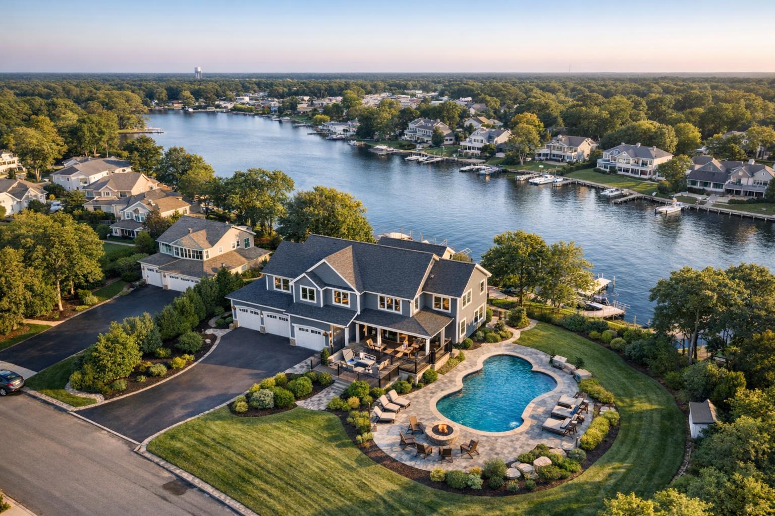
Drone photography in NJ captures a stunning lakeside neighborhood featuring a large house with a pool, surrounded by lush greenery.
Drone Photography NJ: Elevated Listing Success Through Real Experience
Drone photography NJ isn’t just a trend—it’s a game-changing strategy for real estate pros aiming to capture serious buyer attention in a crowded tri-state market. If you’re a broker, agent, host, or property manager determined to make your listings pop, understanding how drone imagery changes first impressions is critical. This post draws on direct production experience and dives deep into how drone photography real estate services—combined with streamlined workflows and consistent professionalism—move the needle for New Jersey and NYC-area listings. You'll walk away with an informed view on aerial photography's real-world impact, how leading north jersey real estate photographers work, and practical ways to book, price, and benefit from best-in-class visual media.
The Real-World Problem: Flat Listings in a Competitive Market
Most agents and sellers know the frustration of perfectly good properties underperforming online. In our fieldwork across North Jersey and New York City, we’ve seen firsthand how properties get overlooked for reasons that have nothing to do with price or square footage:
- Low click-through rates: Listing photos blend into scrolling feeds—especially when shot indoors, with poor framing or uninspired daylight.
- Weak first impressions: Overexposed windows, cluttered rooms, and harsh overhead lighting result in photos that just don't “wow” online viewers.
- Empty or impersonal shots: Vacant spaces captured at chest height lack context and scale, making it tough for buyers to picture living there.
- Limited buyer imagination: Without strong visuals showing the full site, buyers may never see the potential—a big concern for unique lots, amenity-rich apartments, or properties with transformative outdoor spaces.
- Slow buyer engagement: Inconsistent photo quality or missing aerial views can mean buyers move on to flashier listings, even if your property holds more value.
- Inconsistent branding: Media that varies in quality or style undermines agents looking to build trust with a recognizable, polished approach.
We’ve seen listings with beautiful interiors lose traction because their location, curb appeal, or neighborhood features were invisible from ground shots. Worse, snapped-phone images or hasty amateur edits reflect poorly—not only on the property, but the agent’s reputation. That’s where specialized drone photography real estate work, done by experienced teams, radically changes the game.
What Experienced Media Teams Know
Teams that consistently produce high-performing property visuals know there’s no shortcut to eye-catching, credible listing media. Here’s what really goes into professional real estate photography—especially for aerial imagery in NJ, NYC, and the surrounding areas:
- Lighting timing is everything: Optimal shoots happen during “golden hour,” when sunlight reveals property contours and softens harsh shadows. This includes careful planning for morning east-facing exteriors or late-day backyard features.
- Site prep matters: We always advise clearing driveways, staging outdoor furniture, and ensuring landscaping is tidy before any drone takes off—nothing undermines aerial drama like visible trash cans or clutter.
- Aerial framing counts: A professional north Jersey real estate photographer understands how to shoot at varying altitudes, capturing not just the house but access roads, pools, nearby parks, and amenities that shape buyer perceptions.
- Consistent editing and delivery: It’s not just about snapping the shot—a repeatable editorial workflow ensures every image, ground and drone, fits the agent’s brand and meets listing platform requirements (MLS sizing, color standards, and vertical correction for tall buildings).
- Safety and compliance: Only FAA-certified drone pilots can legally fly in many NJ/NYC metro airspaces. Experienced media teams schedule around weather windows, flight restrictions, and privacy concerns.
We’ve learned over hundreds of shoots that clients worry, rightly, about rushed production, unpredictable image quality, and missed details. That's why the best drone photography NJ teams never wing it—they follow proven, repeatable processes and keep communication open from booking to final delivery.
How RealtaSnap Solves It
When you work with RealtaSnap, you don’t just get stunning drone footage—you get the benefits of a team grounded in hands-on production, local expertise, and reliability. Here’s how we raise the bar:
- FAA-Certified Drone Pilots: Every shoot is assigned to a pilot trained and licensed for the NY/NJ market. This isn’t just good optics; it's federally mandated, ensures safe operations, and guarantees you images captured with advanced, professional-grade equipment.
- Media Delivered in 24 Hours: Time is leverage in real estate. RealtaSnap’s streamlined editing workflow means your listing assets—drone photos, video, or virtual tours—are returned fully edited within 24 hours of shooting.
- Showcase the Full Picture: We always include not just the property footprint but neighborhood context—parks, major commuter lines, landmarks, and site access—adding real value for clients who want more than just curb appeal.
- Seamless Online Booking and Dashboard Management: Scheduling, asset download, and status tracking are all handled online through a clean, user-friendly portal. Agents spend less time coordinating shoots and more time marketing.
- Transparent, Competitive Pricing: For drone stills, pricing starts at $175 per listing for up to 10 MLS-ready aerial images, with add-ons for video and neighborhood flyovers. All prices and information are subject to change. Information is deemed reliable but not guaranteed .
- Expert Guidance Throughout: We provide site prep checklists, fast rescheduling during weather delays, and responsive support—because a smooth shoot day equals a better listing.
- Consistent, On-Brand Delivery: Every set of images and clips is carefully batch-corrected for exposure, white balance, and perspective—so even multi-property agents enjoy cohesive media.
RealtaSnap isn’t just another listing photo provider. Our team draws on deep field experience as former agents, marketers, and professional editors, ensuring every shot works hard for you and your brand.
For details or to schedule your shoot, visit www.realtasnap.com.
Benefits of Choosing RealtaSnap
- FAA-certified pilots ensure safe, legal operations.
- Clean, natural editing for MLS-ready aerial assets.
- Delivery within 24 hours—never wait for your media.
- Book, manage, and download via an online dashboard.
- Transparent pricing with no hidden fees.
- Consistent results for single listings or multi-property agents.
- Neighborhood and amenity shots available for stronger context.
- Preparation checklists guide every successful drone shoot.
- Friendly, proactive client support from a field-tested team.
- Flexible service across NYC, New Jersey, and select suburban markets.
Why This Matters in the NYC / NJ Market
Properties in the NYC/NJ corridor aren’t like those in less competitive markets. Here, even starter homes and rentals demand polished listings to catch busy buyers. Urban condos might back up to city parks, waterfronts, or greenways that only aerials can truly reveal. In New Jersey’s north and central neighborhoods, detached homes and new developments rely on drone overviews to spotlight lot size, backyard amenities, and commute routes—a level of detail impossible with ground-level shots. Rental competition is fierce, and buyers often look from abroad or out-of-state, making comprehensive visuals critical for online decision-making.
Common ground-level media can miss power lines out front, access to mass transit, or proximity to shopping—details buyers notice when comparing listings. Aerial drone photography NJ offerings give agents control over that narrative, showing not just what’s inside but what makes each address unique on the block.
Comparison with Traditional or Lower-Quality Alternatives
When agents rely on rushed iPhone photos or uncoordinated freelancers, the shortcomings show:
- Limited Perspective: Ground-level shots fail to capture lot size, unique landscaping, or how the property sits in its context.
- Inconsistent Quality: Unedited or mismatched photo batches lead to uneven branding and lower perceived professionalism.
- Delayed Delivery: Older models often involve manual file handoffs and extended waits for finished images—hurting listing momentum.
- Regulatory Risks: Unlicensed drone operators risk fines, failed flights, and lost time.
- Missed Details: Amateurs may overlook power line avoidance, vertical correction, or weather impacts—leading to subpar results.
Working with an established real estate media specialist like RealtaSnap means you get not just beautiful images, but a workflow that fits modern listing needs. From initial booking through to image delivery, you know exactly what to expect—and you avoid the headaches that frustrate both sellers and agents.
Conclusion & Call to Action
In a market where every impression counts, drone photography NJ services from RealtaSnap help agents and sellers outpace the competition with visual storytelling that truly connects with buyers. Our experience behind the lens—and behind the desk—has shown that well-produced, fast-turnaround aerial media isn’t “extra.” It’s essential. Don’t let your next listing fade into the scroll. See first-hand how aerial perspectives, delivered by north jersey real estate photographers and professional editors, improve clicks, engagement, and brand perception. Ready to upgrade your listings? Book your drone photo shoot today with RealtaSnap and discover what true media expertise can do.
Frequently Asked Questions
1. Do I really need drone images if my property isn’t a luxury home or a new development?
Absolutely. We find that drone photography real estate approaches add value not just for luxury listings but for suburban homes, urban condos, rentals, and even investment properties. Aerials can show location advantages and site details often missed at ground level—making any listing stand out, regardless of price range.
2. How do I know if drone flights are allowed for my listing location?
Our team checks FAA regulations before every shoot, and our certified pilots plan routes to avoid restricted zones or no-fly areas. If your listing is near an airport or in a controlled zone, we’ll advise you on safe alternatives or timeframes. You’re never left guessing—RealtaSnap handles the technical details.
3. What if bad weather or last-minute changes threaten my scheduled shoot?
We monitor weather closely, and our team reaches out proactively when rescheduling is needed. Your timeline stays on track, and you can always manage, reschedule, or follow up on your shoots through our online dashboard. With RealtaSnap, your listing never falls behind due to unforeseen hurdles.
For seamless, expert-run drone photography in North Jersey, NYC, and beyond, trust the team that works where you work. Learn more and explore our portfolio at www.realtasnap.com.


