The Impact of Drone Photography on Curb Appeal in NYC Real Estate Listings
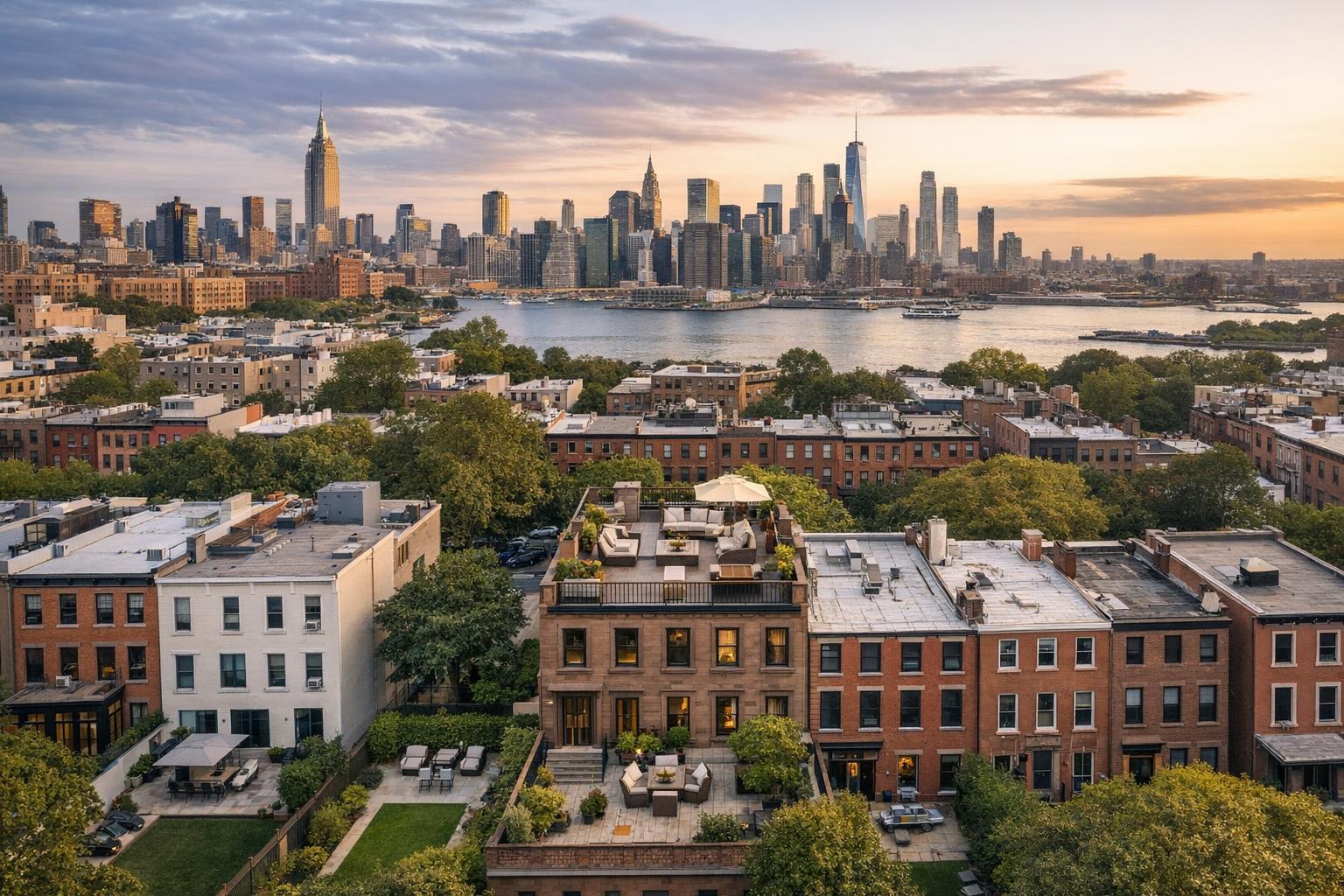
Drone photography captures a stunning view of NYC's skyline with lush greenery and charming rooftops in the foreground.
Drone Photography NYC: Transforming Real Estate Listings and Buyer Engagement
When marketing property in one of the world’s most competitive regions, few tools compare to drone photography NYC services for grabbing attention, elevating listing appeal, and helping buyers see the true potential of a space. In today’s digital marketplace, blending professional aerial imagery with expert real estate photography isn’t a luxury—it’s a competitive standard. On top NYC platforms and across New York and New Jersey, listings captured by experienced teams using aerial real estate photography consistently stand out, improve engagement rates, and shorten days on market. In this post, we’re sharing our direct expertise in drone photography for real estate, practical insights from hundreds of shoots, and what every agent, broker, and property manager should know to win more buyers—and better listings—in NYC and New Jersey.
The Real-World Problem: Standard Listing Media Falls Short
Even the city’s most beautiful properties can underwhelm online when images are flat, poorly lit, or fail to showcase true scale and neighborhood context. It's a familiar story: a listing goes live with hurried phone photos, limited perspectives, washed-out exteriors, or empty rooms. The result? Low click-through rates, lackluster first impressions, and buyers who struggle to imagine the property's full potential.
Specific issues that we’ve seen firsthand in NYC listings include:
- City apartments that appear smaller without aerial overviews, missing the “wow” factor of dramatic skyline views.
- Townhomes or brownstones that lose character when photographed solely from eye level, without revealing private rooftops or garden spaces.
- Amenity-rich buildings left unappreciated when key features (like a rooftop deck or community garden) aren't properly showcased from above.
- Homes with poor natural light or awkward layouts that look uninspiring in standard ground-level shots.
Agents and owners regularly tell us how these challenges result in weak engagement, lingering inventory, and missed follow-up opportunities. In the NYC and NJ markets—where buyer attention is brief and listings surface by the minute—presentation truly is everything.
What Experienced Media Teams Know
From our years in the field producing listing media across New York and New Jersey, we’ve learned that the right visual strategy is as much about preparation and workflow as it is about state-of-the-art hardware:
- Optimal Lighting Windows: Drone and interior shots are best timed during morning or late-afternoon hours for balanced, flattering natural light and dynamic sky backgrounds. Shooting at midday risks harsh shadows and blown-out highlights, especially against glass facades or water views.
- Room and Exterior Prep: Before any drone or camera takes off, we coordinate with agents to tidy rooftops, remove personal items (think BBQ grills or storage bins on balconies), and ensure building permissions for flights meet NYC’s evolving regulations.
- Precision Framing and Perspective: Capturing the right aerial angle—whether to show off a private terrace, street frontage, or skyline proximity—takes both piloting skill and real estate intuition. Framing matters, from correcting skewed verticals on high-rises to balancing exposures between windows and interiors.
- Efficiency and Turnaround: In the city especially, there’s little room for error; from setup to final edit, our crews work tight schedules so properties always hit the market at their most polished, often within 24–48 hours.
These operational touchpoints all play a role in what makes drone photography real estate media impactful—and require far more than simply owning a drone.
How RealtaSnap Solves It
At RealtaSnap, every drone photography NYC shoot is handled with purpose, precision, and an insider’s sensitivity to real estate goals. Our process begins long before takeoff, with compliance checks for NYC airspace and building permissions, helping agents avoid liability headaches or last-minute delays. Our FAA-certified pilots and visual strategists work directly with property representatives to plan each shoot, advise on staging, and identify unique visual selling points—from historic facades in Brooklyn to leafy suburban parcels in New Jersey.
Every deliverable (whether dramatic aerials, sweeping video, or detailed interior stills) is:
- Consistently color-corrected and professionally edited by in-house specialists who know what buyers actually look for on listing platforms.
- Turned around rapidly—standard next-day delivery for most packages—so agents can launch while momentum is high.
- Delivered in formats optimized for the MLS, Zillow, StreetEasy, and social. This saves agents and teams hours of frustrating rework.
- Priced transparently and fairly; our drone photo add-on starts at only $99 for select packages (all prices and information are subject to change. Information is deemed reliable but not guaranteed).
It’s a seamless, end-to-end experience aimed at making every NYC or NJ listing look (and perform) at its best—whether it’s a penthouse, a brownstone, or a multi-family property. Explore more about our aerial real estate photography on the RealtaSnap Drone Services page.
Benefits of Choosing RealtaSnap
- Fully NYC-compliant, insured drone operations
- FAA-certified, real estate-experienced pilots
- Rapid 24–48 hour turnaround on most projects
- Consistent, professional-grade editing every time
- Integrated scheduling with standard and premium photo/video packages
- MLS and platform-ready deliverables
- Flexible package add-ons (drone, video, 3D, floor plans)
- Reliable customer support by proven NYC/NJ media pros
Why This Matters in the NYC / NJ Market
The New York Metro area is unlike any other. With ultra-compressed listing cycles, high buyer expectations, and immense competition (among both sales and rentals), visual media isn’t an afterthought—it’s a launch weapon. Manhattan, Brooklyn, Jersey City, Hoboken, and adjacent suburbs all present different staging, lighting, and property typologies:
- Urban Listings: High-rise condos demand aerials that illustrate location, amenities, and prestigious addresses.
- Townhomes & Multi-Family Properties: Buyers want to see exteriors, backyard space, and neighborhood context—something only drone imagery conveys fully.
- Luxury Rentals: In markets where tenants scroll dozens of listings daily, aerial perspectives instantly distinguish premium addresses, increasing tour requests.
In these districts, fast-moving buyers frequently rely on visuals to cull their shortlists—even before a showing. That’s why timely, high-quality drone photography real estate imagery provides a distinct market edge.
Comparison with Traditional or Lower-Quality Alternatives
While DIY or phone-shot photos might seem cost-effective, the gaps in impact—and potential for missed opportunities—are substantial:
- Inconsistent Staging & Prep: Unplanned shoots lead to clutter, unbalanced lighting, or distracting street elements.
- Skewed Angles & Poor Framing: Novice drone operators often produce tilted, out-of-focus images that work against the listing.
- Slow or Missed Deadlines: Delays in editing or erratic file delivery can mean lost openings in a crowded market.
- MLS Submission Issues: Non-professional media frequently fails MLS technical guidelines, resulting in display errors or rejected listings.
- Missed Buyer Engagement: Listings with basic phone photos or generic media blend in, losing out to neighbors using professional-grade aerial real estate photography.
Effective, trustworthy service is less about gadgets and more about process, reliability, and repeatable quality. That’s where a specialized team like RealtaSnap makes all the difference. Learn how RealtaSnap’s NYC/NJ drone and photo packages support every type of listing and agent workflow.
Conclusion & Call to Action
If you’re representing property in New York or New Jersey, the stakes are too high for lackluster visuals. True buyer engagement and successful sales or rentals start with compelling, standout photography—supported by trusted aerial solutions and deep local experience. At RealtaSnap, we bring hundreds of successful shoots, nuanced compliance knowledge, and an unwavering focus on agent success to every property.
Ready to take your next listing to new heights?
Learn more or schedule a session today at www.realtasnap.com for NYC’s most reliable, proven drone photography real estate team.
Frequently Asked Questions
1. Can I use drone photography for any property in NYC?
NYC airspace is tightly regulated due to safety and privacy laws. At RealtaSnap, we handle all compliance checks, permissions, and FAA certifications so shoots are only performed where and when allowed. Our team can advise you on alternatives—like simulated aerial composites—when drones aren’t viable, reassuring you that your listing will always get its best shot.
2. Is drone photography really worth the extra investment for my listing?
Absolutely. Listings with aerial real estate photography almost always gain higher visibility and buyer engagement—especially in dense urban markets. Many agents report more showings within days of posting professional-grade drone aerials. At RealtaSnap, we keep costs transparent and integrate drone services seamlessly, so you maximize listing impact with no wasted effort.
3. How quickly can I get my drone photos or videos after the shoot?
Speed matters here. Most RealtaSnap drone shoots are delivered within 24–48 hours after the on-site session, complete with post-production editing that meets MLS standards. You’ll have everything ready in time to launch your campaigns, knowing you’re presenting your property at its absolute best, with zero hassle.


