The Impact of Drone Photography on Commercial Real Estate Marketing in North Jersey
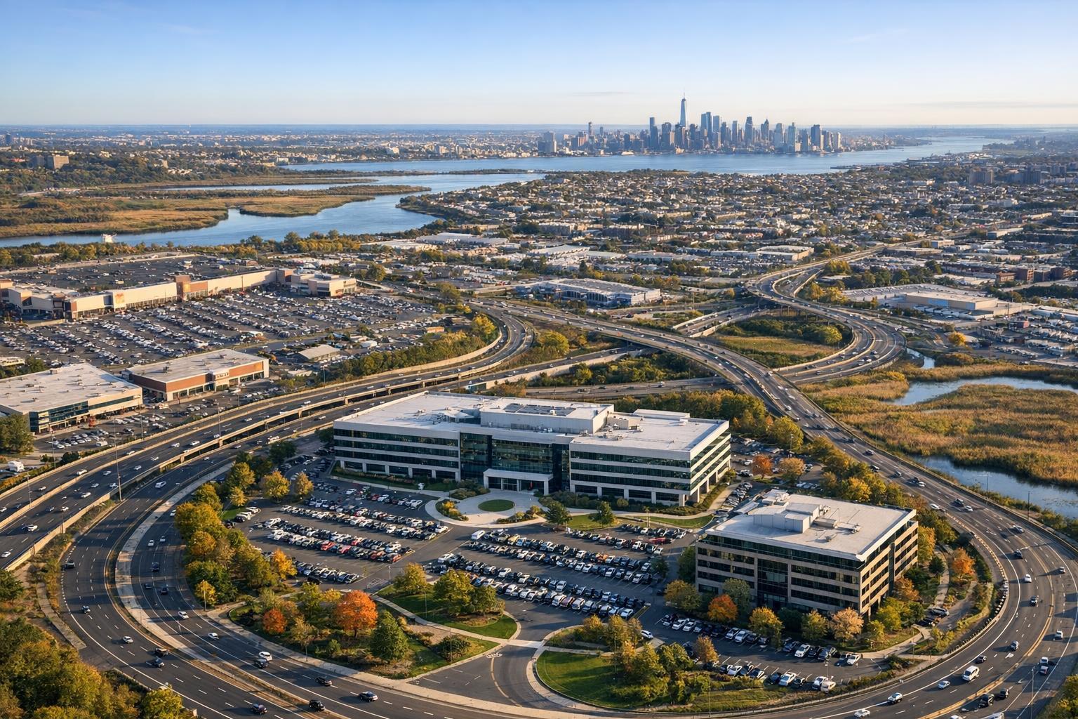
Captured by drone photography NJ, a complex web of highways and buildings is seen with the New York City skyline in the background.
Drone Photography NJ: Elevating Commercial Real Estate Listings with Aerial Real Estate Visuals
Drone photography NJ is transforming the way commercial properties are marketed by delivering compelling aerial real estate visuals that help listings stand out in a crowded, competitive market—especially in NYC, North Jersey, and the surrounding region. In this guide, you’ll learn how leveraging expert drone media can drive visibility, generate stronger buyer impressions, and help agents or property managers get results that ordinary photos can’t achieve.
The Real-World Problem: Listing Media That Fails to Make an Impact
If you’ve listed or represented commercial properties in North Jersey, you already know the challenge: static photos and uninspired media often blend into an endless scroll of listings fighting for attention. Over and over, we’ve seen what happens when sellers rely on lower-quality visuals—fewer clicks, fewer inquiries, and prolonged time on market, especially in high-density, high-value locations.
Common hurdles we see on the ground include:
- Listings that look flat, empty, or lack context (think blank conference rooms or sterile lobbies)
- Poorly-lit interiors that hide layout and detail, or wide windows that blow out the view
- Outdoor photos that miss showing access, amenities, or parking—crucial for many NJ and NYC buyers
- A weak sense of scale, location, or neighborhood context
- Visuals that fail to connect with premium buyers or tenants, especially for unique properties
Without high-impact aerial real estate visuals, even premium office buildings, retail sites, or industrial assets risk fading into the background. Agents in our market face high stakes. The first impression (often made by a thumbnail image on the MLS or Crexi) can make or break the next inquiry.
What Experienced Media Teams Know: Production Matters for Listing Performance
From years spent in the field, at sunrise shoots in Jersey City or fast-paced evenings in Midtown, we’ve learned that great media is never accidental. Seasoned real estate photographers and drone pilots know:
- Golden hour matters: Early morning or late afternoon light brings out exterior textures, highlights landscaping, and avoids harsh shadows or glare on glass. We schedule drone flights to maximize natural light and minimize wind or weather risk.
- Preparation pays off: We collaborate with site managers for pre-shoot walk-throughs. Removing vehicles from parking lots, opening curtains, and timing rooftop access all impact aerial results.
- Framing and height aren’t guesswork: Every property gets a custom flight plan—lower, sweeping angles emphasize curb appeal and show walkability; higher shots put the property in context by revealing proximity to major highways, transit, or waterfront.
- Post-production is crucial: Raw drone footage often needs vertical line correction, exposure blending, and controlled color grading, especially for glass-heavy modern buildings. Inconsistent editing causes listings to look off-balance or amateurish alongside broker-branded marketing.
Our experience tells us that buyers and tenants aren’t just choosing properties—they’re choosing listings that earn their attention in the first seconds of a search.
How RealtaSnap Solves It: Reliable, Impactful Drone Media & Aerial Visuals
At RealtaSnap, we offer purpose-built drone photography and videography for NJ and NYC commercial real estate. Every shoot is handled by certified, insured drone pilots with extensive experience flying in complex airspace and urban neighborhoods—helping ensure safety, compliance, and truly marketable results.
We deliver:
- Dramatic aerial views and cinematic videos that highlight the property’s best attributes—size, surroundings, amenities, and access routes
- A streamlined booking experience through our client portal, allowing you to schedule online and communicate about site details with ease
- Seamlessly integrated in-house editing for perfectly balanced skies, corrected vertical lines, and editing tailored to your branding
- Ultra-quick turnaround times (often within 24-48 hours of the shoot), so your listing goes live with high-impact visuals right away
- Reliable coordination—we know how to manage property access, HOA or city permissions, and day-of logistics for drone flights in dense environments
- Clear, upfront pricing: Commercial drone photography packages start at $295, with video add-ons available. Both photography and bundled packages deliver value without confusing add-ons or unexpected fees. All prices and information are subject to change. Information is deemed reliable but not guaranteed.
Our mission is to give NYC and NJ agents, hosts, and property owners the creative edge needed in fast-moving markets—all with technology and service designed for real-world commercial real estate.
Learn more or book your drone media session here.
Key Benefits of Choosing RealtaSnap
- FAA-certified pilots for legal, safe drone operations
- In-house editing for every visual, not just one-size-fits-all
- 24- to 48-hour digital delivery so listings launch fast
- Photo, video, and 3D mapping packages to fit any property size
- Proven experience shooting in NYC, North Jersey, and urban-suburban environments
- Online portal with transparent pricing and scheduling
- Aerial visuals tailored for commercial platforms (CoStar, LoopNet, MLS, and more)
- Turnkey service—no need for agent or owner on-site
Why This Matters in the NYC / NJ Market
In the high-density, high-value NYC and New Jersey real estate landscape, superb drone photography isn’t just a bonus—it’s an expectation. Out-of-state investors often rely on aerial views to understand neighborhood context, access, and infrastructure in ways static ground shots can’t communicate.
Whether you’re listing a Jersey City mixed-use building, a suburban flex warehouse in Bergen County, or prime retail on the Gold Coast, the right visuals set expectations and drive engagement in a market where seconds on a listing page count. Competition is fierce, and buyers demand instant clarity on what sets your property apart. Strong aerial real estate visuals are now standard for premium listings and are increasingly prioritized on commercial platforms.
Comparison With Traditional or Weaker Solutions
We’ve often been called in to reshoot properties listed with rushed photos, phone snapshots, or footage by generalist providers:
- Phone photos rarely capture true scale, clarity, or the site’s proximity to transit, major employers, or traffic flows.
- Rushed media often misses golden-hour opportunities and leaves problematic shadows, unclear access points, or unwanted clutter in the frame.
- Inconsistent editing or DIY photo stitching can yield disjointed visuals that feel amateurish and cost agents precious credibility.
- Delayed delivery slows your property launch. When you’re waiting on media, you’re losing buyer momentum.
- Generic providers might deliver images, but rarely provide branding continuity, context, or the consultative approach that ties visuals to client goals in NJ and NYC.
RealtaSnap is built around operational excellence—from lighting and timing strategy to delivery and support—making us a trusted partner for professionals who understand that media quality is foundational for commercial real estate marketing.
Conclusion & Call to Action
For commercial agents, property managers, and owners in New Jersey and New York City, the stakes have never been higher for standing out visually. The right drone photography NJ package can be the difference between quick engagement and a listing that languishes unseen—especially as buyer expectations and competition only increase.
RealtaSnap’s team brings hands-on, local expertise, tech-forward convenience, and reliable, editorial-quality results. Your listings deserve to shine—in every frame, on every platform.
Ready to upgrade your next property launch? Get started with RealtaSnap’s aerial photography and see what expert, production-focused media can do for your commercial portfolio.
Frequently Asked Questions
1. How are drone photos used in commercial real estate listings?
Many commercial agents use aerial real estate visuals to show the layout, property boundaries, and proximity to highways or amenities—info critical for buyers and tenants evaluating potential locations. Drone photos can be featured as lead images on MLS, CoStar, LoopNet, and in marketing decks, instantly increasing attention compared to ground-level views.
2. What about legal compliance and permissions for drone photography in NJ/NYC?
Legal drone operations require FAA certification, insurance, and sometimes local permits, especially near busy airports or restricted airspace. At RealtaSnap, every drone operator is certified, and our team handles required waivers or permissions, so you can focus on listing strategy—not regulatory details.
3. How fast will I receive my drone media after the shoot?
We know fast delivery is essential in these markets. RealtaSnap typically delivers fully-edited drone photos and videos within 24–48 hours after your session. This quick turnaround helps you launch listings while buyer interest is hottest—with no long waiting period.
Want to see more? Explore our full service lineup and book your next shoot at www.realtasnap.com.


