The Impact of Drone Photography NJ on the Evolution of North Jersey Real Estate Listings
Drone photography in NJ captures a stunning suburban landscape with a poolside home, lush greenery, and the New York City skyline in the distance.
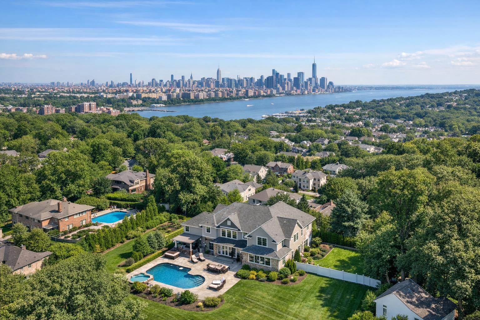
Drone Photography NJ: Elevate Your North Jersey Listings with RealtaSnap’s Trusted Workflow
Drone photography NJ has quickly become the secret weapon for North Jersey real estate agents who want their properties to make an unforgettable impression. In this article, you’ll learn exactly how aerial imagery is changing the listing game, why experienced media professionals insist on using dedicated drone specialists, and what sets RealtaSnap’s drone photography solutions apart for agents targeting today’s fast-moving markets. We’ll share real-world scenarios, specific operational insights, and practical solutions to the listing challenges you face every week.
The Real-World Problem in North Jersey Property Marketing
Ask any north jersey real estate photographer: standing out in a competitive market is tougher than ever. Properties hit StreetEasy, Zillow, or MLS, and in a split second, prospective buyers or renters scroll past a sea of nearly identical thumbnails. Without true aerial perspective, urban condos, suburban homes, and new developments in NJ risk blending into the background.
The friction often starts before the first showing. Agents struggle with poor lighting, uninspiring exterior shots, and ground-level images that don’t capture the story of the property—especially if it’s tucked into a block of lookalike homes or set in a leafy neighborhood where the curb appeal is hidden from the street. Empty spaces, awkward angles, and inconsistent visual branding create weak first impressions that linger. Buyers can’t see proximity to parks, commuter rail, or waterfronts. Sellers get frustrated when their home’s unique setting never gets the spotlight it deserves.
We hear it from agents in towns like Hoboken, Montclair, and Fort Lee all the time: “My listing photos aren’t telling the full story. I need buyers to feel the potential before they even schedule a tour.” The risk? Lower click-through rates, sluggish buyer engagement, and listings that grow stale before you have time to adjust the price.
What Experienced Media Teams Know About Drone Photography for Real Estate
Here’s what the pros see in the field: Beautiful photos are about more than pointing a camera and snapping a few exteriors. For drone photography real estate projects, teamwork and hands-on knowledge matter.
First, timing is critical. In NJ, the “golden hour” window is short, and unpredictable weather can change your plan in minutes. Professional media crews know to scout locations ahead, checking for obstructions, tree coverage, and sun path to ensure the drone flight highlights the lot’s dimensions and context without glare or odd shadows.
Second, getting clean, vertical lines and natural colors in an aerial photo isn’t automatic. Experience teaches you to adjust white balance for shifting daylight, bracket exposures to blend sky and landscaping detail, and correct for fish-eye distortion caused by wide-angle drone lenses. Even the best flight path is useless if window glare or roof artifacts distract the eye.
From prepping the property—reminding owners to move cars, tidy driveways, or stage patios—to post-flight editing, real estate drone photographers have workflow habits that make or break the final product. Fast turnaround also counts: agents need crisp, consistent aerials to pair with interior shots and floor plans for a unified, professional listing launch.
Let’s not forget compliance. FAA-certified drone pilots are required for commercial real estate shoots, securing flight permissions and adhering to local regulations. It’s the difference between legitimately showcasing a property and risking fines or takedown requests.
How RealtaSnap Solves It: Trusted Aerial Solutions, Fast Turnaround, Seamless Online Booking
RealtaSnap was built by real estate media professionals who know the stakes in North Jersey and the broader NYC metro. Our process takes the guesswork out of drone photography real estate projects by pairing experienced, FAA-certified drone pilots with in-house editing teams and a two-step quality control workflow.
What does that mean for you? Your aerial visuals are captured with industry-leading gear, processed for true-to-life color and clarity, and reviewed for consistent branding—all within a guaranteed 24-hour turnaround. Agents can spend less time chasing media vendors and more time marketing listings.
Booking is incredibly easy with RealtaSnap’s tech-driven system. You can schedule a drone photography session for your NJ property in under 3 minutes using our online platform at www.realtasnap.com/schedule. Final deliverables—high-resolution aerial photos or video—are automatically uploaded to your account, ready to download, share, or add to your favorite listing platforms.
Drone Service Pricing:
- 10 Aerial Photos: $209
- 1-Minute 4K Drone Video: $229
- Photo + Video Combo: $299
There are no hidden fees or confusing upgrade tiers. All drone images are professionally edited using RealtaSnap’s in-house process for clarity and visual impact.
All prices and information are subject to change. Information is deemed reliable but not guaranteed.
Benefits of Choosing RealtaSnap for Drone Photography in North Jersey
- FAA-certified pilots ensure legal, safe aerial shots every time
- True verticals & color-accurate editing for modern listing platforms
- 24-hour turnaround supports quick market launches
- Seamless online scheduling in under 3 minutes
- Bundled packages for photo, video, and floor plans
- Visuals delivered via intuitive desktop and mobile platforms
- Transparent, competitive pricing—no surprise add-ons
Why This Matters in the NYC and NJ Real Estate Market
Urban and suburban properties in the NYC and New Jersey corridor demand more strategic marketing than most. There’s massive competition from nearby listings, diverse property types (from brownstones to new developments), and a tech-savvy client base used to scrolling visually stunning feeds.
Buyers making decisions online expect context at a glance—proximity to transit, parks, the Manhattan skyline, or that rare backyard oasis in Montclair. In fast-moving rental markets, polished aerials catch the eye and signal that your listing is worth a closer look, which is especially important when dozens of nearly identical properties hit the market weekly.
RealtaSnap’s media specialists understand urban density, township permitting quirks, and the unique angles required to show off narrow lots, gated driveways, or rooftop decks. It’s not just about capturing an image—from Edgewater to Westfield, the right angle literally puts value on the map.
Comparison: RealtaSnap’s Drone Solutions vs. Traditional or Lower-Quality Alternatives
Phone photos. Quick drive-by shots. Last-minute scheduling with generic vendors. If you’ve tried any of these approaches, you’ve felt the pain: crooked horizons, washed-out skies, mystery objects in the lawn, or a video so shaky it discourages rather than excites. Worse yet, piecing together separate providers for drone, interior, and video often leads to mismatched lighting, off-brand editing, or long delays between deliverables—at the very moment you need everything, yesterday.
RealtaSnap brings a unified, expert workflow, so your drone photography real estate projects get the right framing, balanced window exposures, and color-matched skies that make listings pop on every device. Our two-step editing process means you never see those subtle but costly issues: haloing around roofs, pixelated tree lines, or shadows that obscure landscaping. With 24-hour delivery and photos formatted for both MLS and modern rental platforms, you’re always ready to launch.
Conclusion & Call to Action
At the end of the day, north jersey real estate photographer teams and agents can’t afford to blend in when the stakes are high. High-quality drone photography isn’t just a luxury—it’s an essential tool to showcase location, scale, and lifestyle on every type of New Jersey property. With RealtaSnap, agents gain a partner who’s as invested in your listing’s success as you are, delivering expertly produced aerial visuals, lightning-fast turnaround, and reliable, transparent pricing.
Get the ball rolling and set your properties apart—book your next drone shoot with RealtaSnap or learn more about our comprehensive services at our real estate drone photography page.
Frequently Asked Questions
1. Will drone photography work for small lots, townhomes, or urban properties?
Absolutely. Our experienced pilots know how to work around tight spaces and local airspace restrictions. We plan each shoot for the property’s size and context, using angles and altitudes that highlight location—whether it’s a cozy townhouse or a downtown high-rise—and always follow the latest regulations for safety.
2. How quickly can I get my final drone photos or video after the shoot?
We guarantee a 24-hour turnaround on all drone deliverables. Our editing team processes and reviews every file so you receive professional, color-accurate visuals fast—ready for your next virtual tour or listing launch.
3. What if I need interior photos, floor plans, or virtual tours in addition to drone images?
You’re in the right place. RealtaSnap offers bundled packages for interiors, drone, floor plans, and even 3D virtual tours. With one easy booking, you can build a visual suite that makes your listing shine on every platform. That’s real convenience and consistency from a single, trusted partner.
All prices and information are subject to change. Information is deemed reliable but not guaranteed.


