The Evolving Role of Drone Photography in New York City Real Estate Marketing
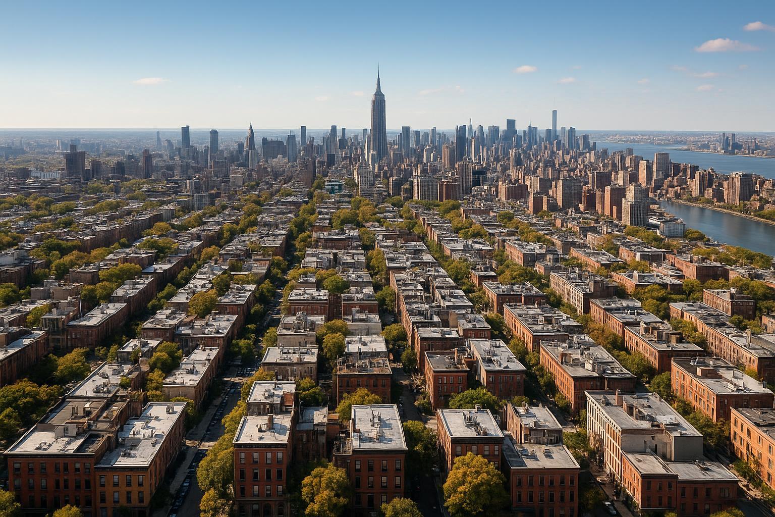
Drone photography captures a sprawling urban landscape with rows of residential buildings and the iconic skyline in the distance, highlighting prime real estate value.
Drone Photography Real Estate: How Aerial Imagery Is Changing NYC Real Estate Marketing
If you’re looking for ways to elevate your real estate marketing in NYC, drone photography real estate has become one of the most powerful tools for agents, property owners, and marketing teams. High-quality aerial real estate photography not only captures a property’s full story, but also showcases features that traditional photography can’t reach—giving listings a competitive edge in fast-moving urban and suburban markets. In this article, you’ll learn how drone imagery revolutionizes real estate marketing nyc, why agents and sellers should care, and what it takes to get it right in New York City and New Jersey.
The Real-World Problem
Without professional drone or aerial photography, many NYC and NJ listings face frustrating challenges. We've seen it firsthand as media specialists:
- Most listings rely on ground-level photos that can’t capture building scale, block views, outdoor amenities, or rooftop access.
- Weak first impressions: With only a fraction of properties featuring true aerial perspectives, those without drone images often blend into a crowded, thumbnail-driven marketplace.
- Agents struggle to communicate unique selling points—like private terraces, skyline views, or the relationship between building, park, and neighborhood.
- Inconsistent branding: A listing with basic phone or rushed camera photos doesn’t deliver the consistent, polished look buyers expect—especially in premium categories.
- High-value features are easily missed or minimized: Pool areas, courtyards, rooftop spaces, parking setups, and proximity to local highlights all go unnoticed.
- Urban constraints: NYC listings, in particular, suffer from cramped street views, poor natural lighting, and tight angles that fail to convey a true sense of space or surroundings.
We've worked with agents who report that listing engagement often plateaus unless visuals spark immediate interest. A lack of elevated imagery means fewer clicks, lower inquiry rates, and more time on market—results no real estate professional wants.
What Experienced Media Teams Know
In the field, professional real estate media teams bring a deep practical understanding of what makes aerial real estate photography (and all listing content) stand out:
- Timing and Lighting: The best aerial shots use either early morning or late afternoon sun to create dimensional shadows, warm highlights, and clear views of the property’s context—crucial for showcasing outdoor amenities and rooftop spaces.
- Framing and Storytelling: We select flight paths that accentuate scale (think, 45-degree oblique shots for high-rises or wide orbit shots for large homes), while carefully balancing cityscape, building outline, and neighborhood features in each frame.
- Regulatory Awareness: NYC’s complex airspace and local permitting rules require that pilots conduct airspace and safety evaluations before each shoot; some addresses simply aren’t flyable, and roof access can be the difference between a spectacular or impossible aerial.
- Workflow and Turnaround: Our team coordinates closely with listing agents to schedule aerials alongside interior shoots, ensuring color consistency and aligned branding. Speed is vital—turnaround is typically within 24-48 hours, so agents can launch or refresh listings fast.
The value of drone imagery isn’t just technical. On listing platforms, we’ve observed that the first five gallery images shape a buyer’s impression and engagement. A well-placed drone shot of a building’s facade, or of an entire block at golden hour, will consistently outperform even well-shot interiors alone.
How RealtaSnap Solves It
At RealtaSnap, we take an expert and deeply practical approach to producing impactful drone photography for real estate marketing in NYC, New Jersey, and beyond. Our service model is grounded in reliability, visual excellence, and operational efficiency:
- FAA-Compliant Pilots: Every drone operation is conducted by certified, experienced pilots who assess local airspace and obtain necessary FAA clearance, maintaining full regulatory compliance【20:10†RealtaSnap_Service_Execution_Policy_MASTER.docx】.
- Real-World Feasibility Planning: We verify fly zones before scheduling, identify best roof or terrace access for urban jobs, and candidly advise when aerials aren’t possible. This transparency ensures clients avoid wasted time or false expectations.
- Consistent Visual Standards: Drone photos are captured in high-resolution HDR, with blue sky replacement if needed, and professionally color-matched to your property’s gallery. When combined with ground photos, this creates a unified, story-driven listing presentation.
- Flexible Service Options: Need just drone stills? A combination of video and stills? Fast upgrades to social formats? Our booking process handles all mixes, with simple pricing and next-day scheduling available【20:1†RealtaSnap_Booking_Process_MASTER.docx】.
- Fast Turnaround and Seamless Delivery: Most drone photo or video orders are delivered within 24–48 hours, ready for MLS, social, or custom web galleries.
- No-nonsense Editing and Retouching: We provide realistic retouching, skyline adjustments, and object removal if needed (per rate sheet add-ons), keeping every image authentic while maximizing impact.
All prices and information are subject to change. Information is deemed reliable but not guaranteed【20:0†RealtaSnap_Rate_Sheet_MASTER.docx】.
Benefits of Choosing RealtaSnap for Drone Photography
- Certified, insured, FAA-compliant drone pilots every time.
- Pre-flight airspace and neighborhood assessment for safety.
- Blue sky guarantee for marketable, sunny imagery.
- Rapid 24–48 hour turnaround on aerial photos and video.
- Visual brand consistency across all property media.
- Flexible options: photo, video, or combined.
- Price transparency—no hidden fees.
- Simple online booking and real-time scheduling.
- Honest advice when aerial is not feasible.
- Local NYC/NJ expertise with market-specific sensibility.
Why This Matters in NYC, NJ, and Surrounding Markets
NYC and New Jersey present unique challenges—and opportunities—for aerial real estate photography. Manhattan, Brooklyn, and Jersey City listings often feature high-rises, rooftop spaces, and dramatic skyline views that can be the deciding factor for buyers or renters. Suburban homes, on the other hand, benefit from aerials highlighting lot size, curb appeal, and neighborhood amenities.
Urban buyers have elevated expectations: Premium listings compete fiercely, and buyers anticipate a “wow” factor in both photography and marketing. Rental competition is also intense, and luxury developers now use drone tour videos to differentiate new projects. On platforms like StreetEasy, Zillow, and Realtor.com, data shows that listings with professional drone imagery consistently see higher click-through and inquiry rates.
The right aerials can also help agents build personal brands, sign new clients, and stand out in nearly every residential and commercial property segment.
Comparison: RealtaSnap vs. Traditional or Lower-Quality Alternatives
- Phone/DIY Photos: Despite smartphone improvements, handheld or DIY drone shots lack stability, dynamic range, and compositional intent—resulting in distorted lines, overexposed skies, or flat perspectives that hurt listing credibility.
- Rushed or Inexperienced Shoots: Non-specialist providers often fail to account for unique NYC constraints, leading to delays, legal headaches, or outright cancellations due to missed airspace red flags.
- Inconsistent Editing: Piecemeal or generic editing workflows result in mismatched color balancing between drone and ground shots, weakening a listing's cohesive visual story.
- Delayed Delivery: When media isn’t turned around in 24–48 hours, listings languish and lose “new” momentum in MLS feeds.
- Poor Framing or Missed Angles: Unskilled operators may skip key amenities (rooftop, common spaces, street scenes), robbing the listing of its most “clickable” assets.
- No Regulatory Compliance: Illegal flights risk fines, insurance voids, or worse—news headlines. RealtaSnap prioritizes safety, compliance, and honest feasibility assessments.
Conclusion & Call to Action
Drone photography real estate is more than a trend—it’s a necessity for winning attention and trust in NYC and NJ’s competitive market. The stakes, and expectations, are higher than ever before; buyers and renters demand immersive, high-quality media from the very first click. Whether you need to showcase an urban penthouse overlooking Central Park or a sprawling New Jersey estate, professional aerial imagery unlocks new levels of visibility and storytelling power.
If you want to see the difference expert drone photography can make for your next listing, explore our services at RealtaSnap’s Drone Photography & Videography NYC or visit www.realtasnap.com for our full range of offerings.
Frequently Asked Questions
1. What should I know about drone legality in NYC real estate marketing?
Drone operations in NYC are strictly regulated. Only FAA-certified pilots familiar with local airspace and restrictions should perform aerial shoots. At RealtaSnap, we conduct all necessary checks and provide honest feasibility assessments, so your project stays compliant and safe【20:10†RealtaSnap_Service_Execution_Policy_MASTER.docx】.
2. Will every listing benefit from aerial real estate photography?
Not every property is a match for drone imagery. Tight airspace or lack of roof access can limit options, especially in dense NYC neighborhoods. We help you decide if aerials will truly showcase your property’s best features, prioritizing authenticity over gimmicks.
3. How fast can I get my aerial photos or video after the shoot?
Most drone photography and video projects are delivered within 24–48 hours. Our process is designed for fast, reliable turnaround, enabling you to go live with high-impact visuals as soon as possible. RealtaSnap makes hitting your launch window seamless【20:0†RealtaSnap_Rate_Sheet_MASTER.docx】.
Ready to bring your listing above the crowd? Experience the difference with proven, practical expertise—choose RealtaSnap for drone photography real estate in NYC, New Jersey, and the surrounding region.


