Expert Insights on Drone Photography for Real Estate Professionals in NJ
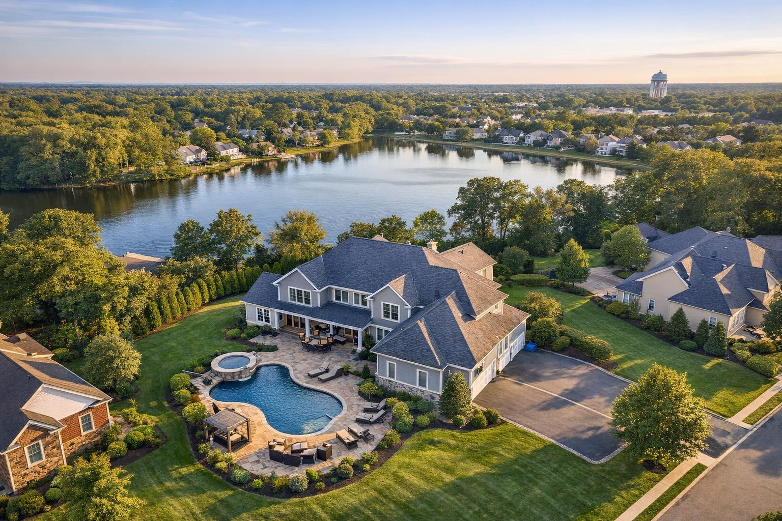
Drone photography in NJ captures a stunning view of a luxurious home with a pool, lush greenery, and a serene lake in the background.
A Complete Guide to Drone Photography for Real Estate in NJ
Introduction
If you’re looking for a competitive edge in property marketing, drone photography NJ is fast becoming a necessity, not a luxury. Today’s buyers expect more visual information upfront—especially in dynamic markets like New Jersey and New York City, where attention spans on listing platforms are short and inventory moves quickly. In this complete guide, you’ll see how drone photography real estate services—also known as aerial real estate photography—can transform your listings, drive engagement, and help your properties stand out in even the most crowded marketplaces. We’ll cover why this media matters, what seasoned real estate photographers know from the field, and actionable tips for getting the most from aerial visuals. Plus, you’ll discover how RealtaSnap streamlines the process for agents, hosts, brokers, and property managers across NJ, NYC, and nearby suburbs.
The Real-World Problem: What Happens Without Quality Drone Media?
We’ve documented hundreds of listings—condos, townhomes, sprawling suburban estates, and urban walkups. Too often, we work with agents frustrated by lackluster results from traditional photography alone:
- Missed Curb Appeal: Ground-level shots can flatten context, hiding key features like lot size, landscaping, roof condition, or the appeal of a corner location.
- Weak Digital First Impressions: On platforms like Zillow and StreetEasy, potential buyers often scroll past listings that don’t “pop” visually. Static, poorly lit, or awkwardly framed images reduce click-through rates by double digits.
- Incomplete Storytelling: Aerial real estate photography fills the gaps—showing proximity to parks, waterfronts, schools, transport lines, or local hotspots. Without it, listings may leave buyers guessing.
- Lost Bids in Competitive Markets: Especially for luxury homes or properties with unique layouts, not showcasing every angle can lead to weaker offers or longer days on market.
- Stagnant Commercial Listings: Retail and mixed-use property managers in NJ have told us that drone images help convey scale and accessibility—essentials for leasing or investment pitches—yet are often missing.
We’ve measured this directly: properties lacking compelling visuals see slower engagement, confused questions from buyers, and unnecessary price drops. Media that fails to reflect “the real feel” simply doesn’t sell the story.
What Experienced Media Teams Know
Field-tested real estate photography isn’t just about expensive equipment or flying a drone overhead. Here’s what a pro team like ours does differently:
- Lighting and Timing: The difference between a dull and a dazzling aerial shot often comes down to the schedule. Golden hour—right after sunrise or before sunset—gives exteriors warmth and shadow depth, whether in the suburbs or Jersey City’s bustling neighborhoods.
- Site Prep and Coordination: Before a drone takes off, we coordinate with homeowners or building management to clear cars from driveways, secure outdoor furniture, and prep amenities (open pool covers, swept patios). Little details like these add polish and minimize retouch requests.
- Framing and Vertical Alignment: We never settle for gimmicky, top-down views. True professionals blend oblique shots (angled to show depth, not just roofs) and perfectly corrected vertical lines, which modern buyers expect, especially in multi-story listings.
- Post-Production Consistency: Aerial images need color grading and window/sky exposure blending to match interior shots—otherwise, your listing looks visually disjointed. We build custom editing profiles to ensure sets are harmonious across all platforms.
- Regulatory Savvy: NJ and NYC airspace is complex—FAA Part 107 is just the start. We pull sectional charts, submit flight plans if near airports, and verify no-fly zones before every shoot.
Bottom line: Great drone photography real estate services are as much about planning and polish as the pictures themselves.
How RealtaSnap Solves It
At RealtaSnap, our process is built around reliability, quality, and convenience. We serve agents and property owners across NJ and the NYC region, specializing in both residential and commercial visual marketing.
- Streamlined Booking and Fast Turnarounds: Most photo and video sessions can be scheduled online in under two minutes. Drone and aerial packages are ready for delivery in as little as 24 hours, with high-resolution files in your inbox and custom gallery access.
- FAA-Licensed Pilots with Local Knowledge: Every shoot is flown by a licensed, insured professional with local market experience. We navigate municipal rules unique to New Jersey’s diverse towns and busy city corridors, keeping you compliant and stress-free.
- Comprehensive Media Bundles: Our drone photography packages are often paired with interior photos, virtual tours, floor plans, and twilight shoots, so you receive a cohesive marketing package—no shopping around for extras.
- Consistent Editing for Brand Cohesion: All visual assets are color-matched, horizon-leveled, and optimally staged for syndication across MLS, Zillow, and brokerage custom sites. This attention to detail means your branding stays consistent and listings look vibrant everywhere.
Want proof? Agents using RealtaSnap’s drone services routinely receive comments about the “wow factor” on their listings, with buyers and renters gaining a much clearer sense of value before ever stepping through the door.
For full package details and a gallery of recent shoots, explore our Drone Photography & Videography NYC page.
Benefits of Choosing RealtaSnap for Drone Photography
- Fast, easy online booking and next-day digital delivery
- FAA-certified, insured pilots with deep local knowledge
- Integrated media—from ground, aerial, and virtual tours—for visual consistency
- Apartments, homes, and commercial spaces showcased at their best angles
- True-to-life editing and sky/window blending for balanced, attractive images
- Flexible scheduling, seven days a week, including evenings and weekends
- All images MLS, Zillow, and rental-platform ready
- Volume discounts for property managers and multi-listing brokers
- Full regulatory compliance and flight planning handled in-house
- Friendly, responsive support from real estate media specialists
Why This Matters in the NYC / NJ Market
Why does aerial real estate photography have so much impact here? Unlike suburban areas with uniform lot sizes, the NYC/NJ corridor is a mosaic: dense city blocks, varied building heights, sprawling towns, historic districts, and waterfront developments. Buyers want—and need—context. Drone visuals instantly reveal walkability, commuting access, and neighborhood amenities, all of which drive ROI for sellers and host reputations for short-term rentals.
Rental competition is particularly fierce in Hoboken, Jersey City, and Hoboken—where renters view dozens of nearly identical listings online. The right drone shot can draw the eye, differentiate your unit, and cut down on “tire-kicker” showings by answering location and lifestyle questions before the tour.
Commercial listings also benefit. Investors and tenants want visual evidence of parking, foot traffic, and proximity to highways or transit. Photos from ground level simply can’t deliver this information effectively, especially for larger parcels or mixed-use properties.
Comparison with Traditional or Lower-Quality Alternatives
We’ve often been called in to rescue listings suffering from old-school photography. Here’s what usually goes wrong when agents cut corners:
- Phone Photos: Even with advanced smartphones, ground shots often have distorted lines, blown-out skies, and missed details. Buyers notice—and judge—these flaws quickly.
- Rushed or Inconsistent Edits: Quick-and-dirty post-processing delivers washed-out colors, harsh shadows, and mismatched photo sets. Listing platforms amplify these inconsistencies.
- Can’t Show Context: A photo from the sidewalk can’t reveal roof condition, backyard depth, or proximity to amenities—essentials in city and suburban settings.
- Delayed Media Delivery: Waiting days for photos slows the listing process. Momentum gets lost, especially when “coming soon” listings promise visuals ASAP.
- Poor Staging Coordination: Un-prepped exteriors (overflowing trash cans, cluttered decks, parked trucks) instantly date images and dampen buyer excitement.
With RealtaSnap, you won’t sacrifice precision, speed, or polish. Our workflow and experience eliminate these pitfalls, giving your listings the visual edge that turns lookers into serious inquiries.
Actionable Tips for Agents Considering Drone Photography
- Prep Before the Shoot: Remove cars, mow lawns, and tidy up outdoor spaces to maximize appeal.
- Prioritize Weather and Timing: Book shoots for clear days and aim for early morning or late afternoon for the best lighting.
- Open Communication: Share your shot list or highlighting must-have angles—like water views, decks, or unique features—to ensure expectations are met.
- Use Full Media Bundles: Combine aerial real estate photography with interiors, video, and floor plans to paint a comprehensive picture.
- Check Local Regulations: Use a provider who knows the FAA rules and local restrictions—in NJ, this can vary block by block.
- Review and Approve Edits: Work with your media team to ensure images align with your brand—consistency matters, especially for teams with multiple listings.
Conclusion & Call to Action
In the fast-paced real estate markets of New Jersey and New York City, drone photography is no longer optional—it’s a proven tool for creating immersive, click-worthy listings that buyers remember. Experienced media partners understand not just how to fly a drone, but how to tell a story, blend visuals, and deliver fast, compliant, and attractive results every time. If you’re ready to elevate your next listing, see more about our drone photography and videography services here, or explore our full suite of visual media for property marketing at RealtaSnap.com.
Frequently Asked Questions
1. Is drone photography legal everywhere in NJ, and how does RealtaSnap handle regulations?
Many agents are concerned about no-fly zones or FAA restrictions in dense areas. RealtaSnap only uses FAA-certified pilots and handles all regulatory checks, permitting, and flight planning for you. We make compliance effortless so you can focus on your listing.
2. How quickly can I receive my drone photos, and what if the weather doesn’t cooperate?
Turnaround time for our drone photography NJ packages is typically 24 hours after the shoot. If weather conditions are unsafe or unflattering on your scheduled day, we’ll work with you to reschedule promptly—without additional hassle.
3. Do aerial real estate photography and ground photos really need to match for branding?
It’s a common concern that inconsistent editing can make listings look piecemeal. RealtaSnap ensures all your visual media—including drone shots—are color corrected, sky-replaced if needed, and brand-matched for a cohesive look across every marketing channel. This keeps your listings sharp and professional.
All prices and information are subject to change. Information is deemed reliable but not guaranteed.


