Drone Photography’s Evolving Role in Showcasing NYC Real Estate Listings
Drone photography in NYC captures a vibrant cityscape featuring a mix of residential buildings and the iconic skyline, including the Empire State Building.
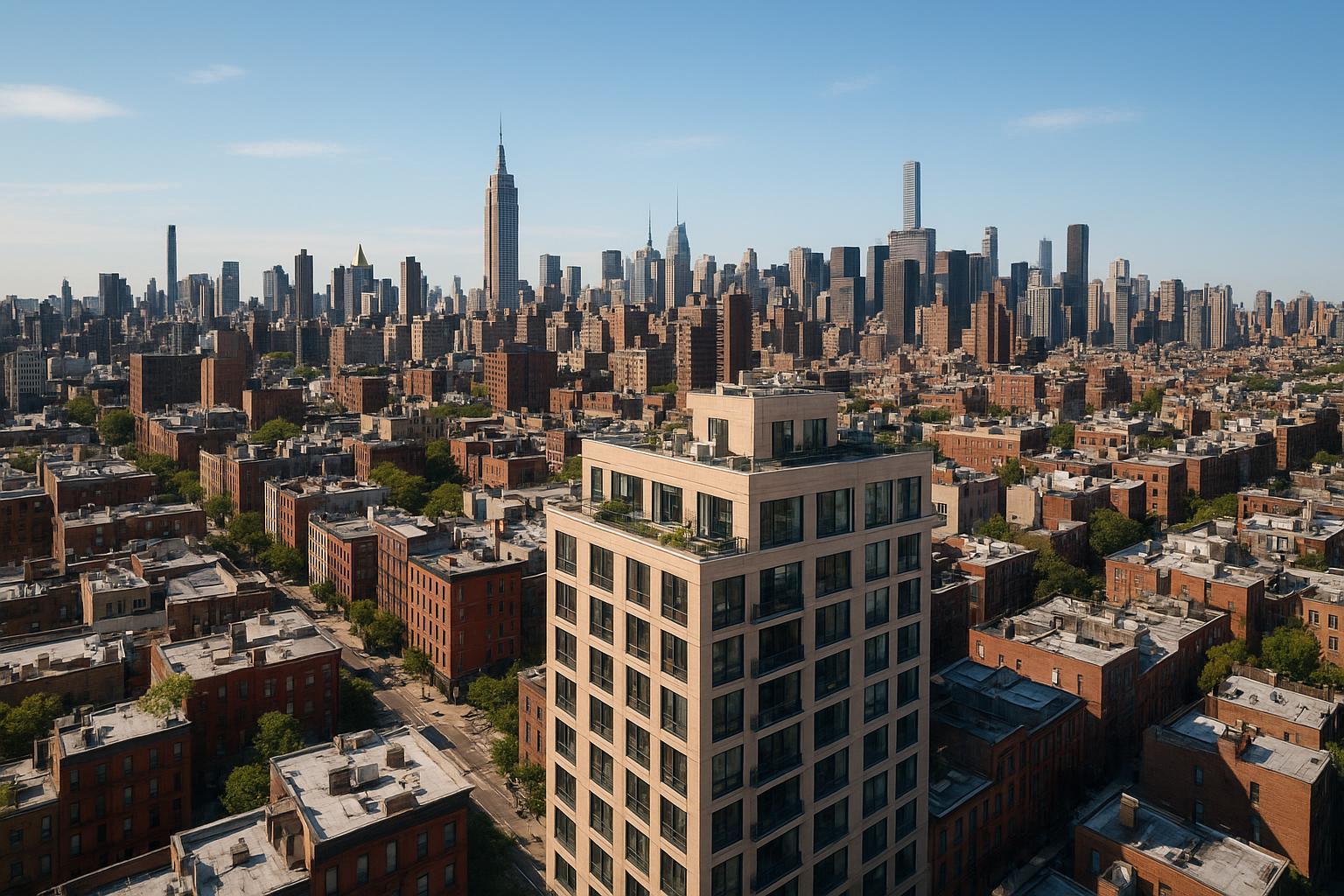
Drone Photography NYC: Elevating Real Estate Listings with Aerial Views
Drone photography NYC is transforming the way properties are showcased and sold, especially in dynamic markets like New York City and New Jersey. In this article, you'll learn how drone photography—known in the industry as drone photography real estate or aerial real estate photos—sets listings apart, the real-world problems it overcomes, NYC’s unique regulations, and how professional media teams like RealtaSnap approach these shoots for maximum impact. Plus, we offer actionable tips on preparing a property and address the most common questions we hear from agents, sellers, and property owners.
The Real-World Problem: Why Drone Photography Matters in NYC Listings
When you list a property in New York or New Jersey, your competition isn’t just the building next door—it’s every listing on every platform, citywide. Agents and property owners contend with challenges such as:
- Listings getting lost in crowded online searches.
- Weak first impressions due to flat, uninspiring photography.
- Lowered buyer excitement because of limited visuals—especially in dense or high-rise settings.
- Poorly-lit ground shots that miss the feel of a property’s location and scale.
- Difficulty showing proximity to parks, water, amenities, or transit.
- Inability to highlight rooftop features, green spaces, or panoramic skyline views.
- Inconsistent branding from DIY or rushed shoots.
- Media that simply doesn’t “sell the story” of the property.
In short, buyers form instant judgments, often skipping to the next listing if your visuals don’t stand out. In urban settings, even beautiful interiors can fade into the background without exterior context. Traditional photography—while essential—rarely provides the scale or excitement that hooks today’s buyers in a split second.
What Experienced Media Teams Know: The Art and Science of NYC Drone Work
Teams with real experience in drone photography real estate know that every aerial shoot is far more than “just flying a drone.” Here’s what separates the professionals:
- Regulatory Know-How: Every flight in NYC must comply with FAA Part 107, airspace rules, and site-specific restrictions. Urban drone work requires evaluating airspace, securing authorizations, and—sometimes—navigating controlled or restricted environments. Without a clear understanding of this landscape, your drone session might not happen at all【20:11†RealtaSnap_Service_Execution_Policy_MASTER.docx】.
- Access & Logistics: Access to the rooftop or terrace can make or break an aerial session. Not all buildings provide this access, and not every address is safe or feasible for a drone pickup.
- Timing Matters: Early morning or late afternoon shoots often deliver the most flattering light and calm conditions, avoiding harsh shadows on building facades.
- Safety & Discretion: Crowded streets, tight alleys, and wind conditions pose real safety concerns. Experienced teams plan each flight, mitigate risks, and work around pedestrian or vehicle activity.
- Visual Storytelling: Professional media teams refuse to accept “one-size-fits-all” shots. They frame each aerial to showcase the property’s context—think view corridors, skyline backdrops, proximity to parks, or dramatic roof decks.
- Editing Expertise: Urban drone images often require vertical correction, blue sky replacement, and careful balancing of window exposures due to reflective city glass and variable lighting.
- Turnaround & Consistency: Urban listings move fast; brokers need next-day media to stay competitive. Reliable teams—like RealtaSnap—deliver on tight timelines with consistent, polished results.
How RealtaSnap Solves It: NYC & NJ Drone Photography, Done Right
At RealtaSnap, we blend regulatory expertise, creative vision, and hands-on urban experience. Here’s how we address the unique challenges of drone photography in New York and New Jersey【20:4†RealtaSnap_Service_Execution_Policy_MASTER.docx】:
- Compliance & Safety: Every drone operator is FAA-certified. We vet each location for airspace restrictions and secure necessary flight authorizations. If the site is not flyable, we’re upfront—saving clients from last-minute surprises.
- Feasibility Evaluations: We assess sites for possible rooftop access, obstructions, and ground-level risks. We do not attempt flights where safety or legality is in question.
- High-Quality Capture: Our drones shoot in high-resolution 4K HDR, with blue sky replacement available if needed—a major asset for cloudy or overcast shoot days.
- Rapid Turnaround: Finished aerial photos and videos are typically delivered in 24–48 hours, supporting the brisk market pace in NYC and NJ.
- Custom Framing: We compose every shot with utmost care, correcting for distortion and maximizing each property’s unique attributes.
- Specialized Urban Workflow: From checklists for property prep (such as clearing balconies) to recommending optimal time slots to avoid midday glare, our workflow is purpose-built for city listings.
- Clear, Predictable Rates: Drone photo packages start at $209 for 10 high-res HDR images, with add-ons available. Photo-video bundles and standalone drone videos are also offered (see the latest rates for specifics—prices may change; all information deemed reliable but not guaranteed)【20:5†RealtaSnap_Rate_Sheet_MASTER.docx】.
For a deeper look at our aerial process or to see sample galleries, visit our NYC drone photography page.
Benefits of Choosing RealtaSnap (Bullet Points)
- FAA-certified pilots ensure legal, safe flights
- High-res 4K HDR photos capture every detail
- Rapid 24–48 hour turnaround on most shoots
- Blue sky replacement included if needed
- Carefully composed shots maximize visual impact
- Advanced editing for vertical and line correction
- Clear, flat-rate pricing for easy budgeting
- Local expertise in NYC and NJ site logistics
Why This Matters in the NYC / NJ Market
New York City and New Jersey rank among the world’s most visually competitive real estate landscapes. Here, buyers expect more than interior shots—they want to see skyline views, neighborhood context, and unique amenities from above. Distinguishing factors in NYC and NJ include:
- High-Rise Living: Many buyers shop for “view” as much as square footage. Drone imagery captures panoramas impossible from inside.
- Urban Density: With buildings tightly packed, expertly timed aerials reduce clutter and frame open spaces, terraces, or unique architectural features.
- Rental & Condo Competition: Hundreds of near-identical listings flood platforms. Standout aerials draw more clicks and virtual tours.
- Diverse Neighborhoods: From historic brownstones to modern skyscrapers and Jersey waterfronts, aerials clarify a property’s place in its larger environment.
- Listing Platform Trends: Portals increasingly surface listings with eye-catching lead images—those with drone photos consistently draw higher engagement.
Comparison with Traditional or Lower-Quality Alternatives
Relying on “phone photos,” amateur pilots, or generic providers can backfire:
- Phone photos miss the scale and grandeur of New York’s vertical cityscapes and ignore FAA compliance.
- Inconsistent providers may delay delivery, misunderstand airspace rules, or deliver uneven quality.
- Rushed or DIY media can introduce risk—either through illegal flights or subpar, unedited images.
- Limited editing leaves skewed verticals, blown-out skies, or distracting reflections.
- Missed details—like window exposure balance, rooftop prep, or travel logistics—lead to cancellations or unusable footage.
When property value, timing, and reputation are at stake, these shortcuts cost far more than they save.
How to Prepare for a Drone Shoot
Agents and sellers in NYC and NJ can get the most out of their drone session by:
- Securing rooftop or terrace access for best aerial vantage points.
- Clearing balconies and rooftops of clutter, debris, or personal items.
- Informing building management about flight windows and anticipated activity.
- Scheduling shoots for early morning or late afternoon to leverage the best light conditions.
- Having backup ground-based perspectives in case weather or airspace issues arise.
A trusted partner provides helpful prep checklists and communicates throughout—this is embedded in RealtaSnap’s workflow.
Conclusion & Call to Action
Drone photography NYC has become an essential ingredient for modern real estate marketing—especially in NYC, New Jersey, and the surrounding region, where competition is fierce and buyer expectations run high. The combination of compliance, visual artistry, practical logistics, and lightning-fast turnaround sets experienced teams like RealtaSnap apart. Ready to take your listings to the next level with professionally executed aerial real estate photos? Discover how RealtaSnap helps agents and sellers stand out—explore our drone photography services here or browse more media solutions at www.realtasnap.com.
Frequently Asked Questions
1. Can you legally fly drones for real estate in NYC and NJ?
Yes—RealtaSnap uses only FAA-certified pilots who thoroughly vet each site for airspace rules and flight restrictions. Some NYC areas require special authorizations, and not every address is flyable. We’ll always be transparent about feasibility and never risk illegal or unsafe flights.
2. What if my building doesn’t allow rooftop access or drone flights?
Limited access is common in NYC and parts of NJ. RealtaSnap evaluates every site in advance and recommends alternative perspectives (such as elevated pole shots or nearby vantage points) if drone flight isn’t possible. We help agents and owners set clear expectations up front.
3. How should I prepare my property for a drone shoot?
Ensure building management is informed, rooftop/balcony spaces are cleared, and access is coordinated for the drone team. Early morning or late afternoon slots often provide the best light. Our team supplies custom prep guidance so clients know exactly what to expect—all part of RealtaSnap’s service approach.
All prices and information are subject to change. Information is deemed reliable but not guaranteed.


