Drone Photography and Its Impact on Real Estate Marketing and Curb Appeal in NYC
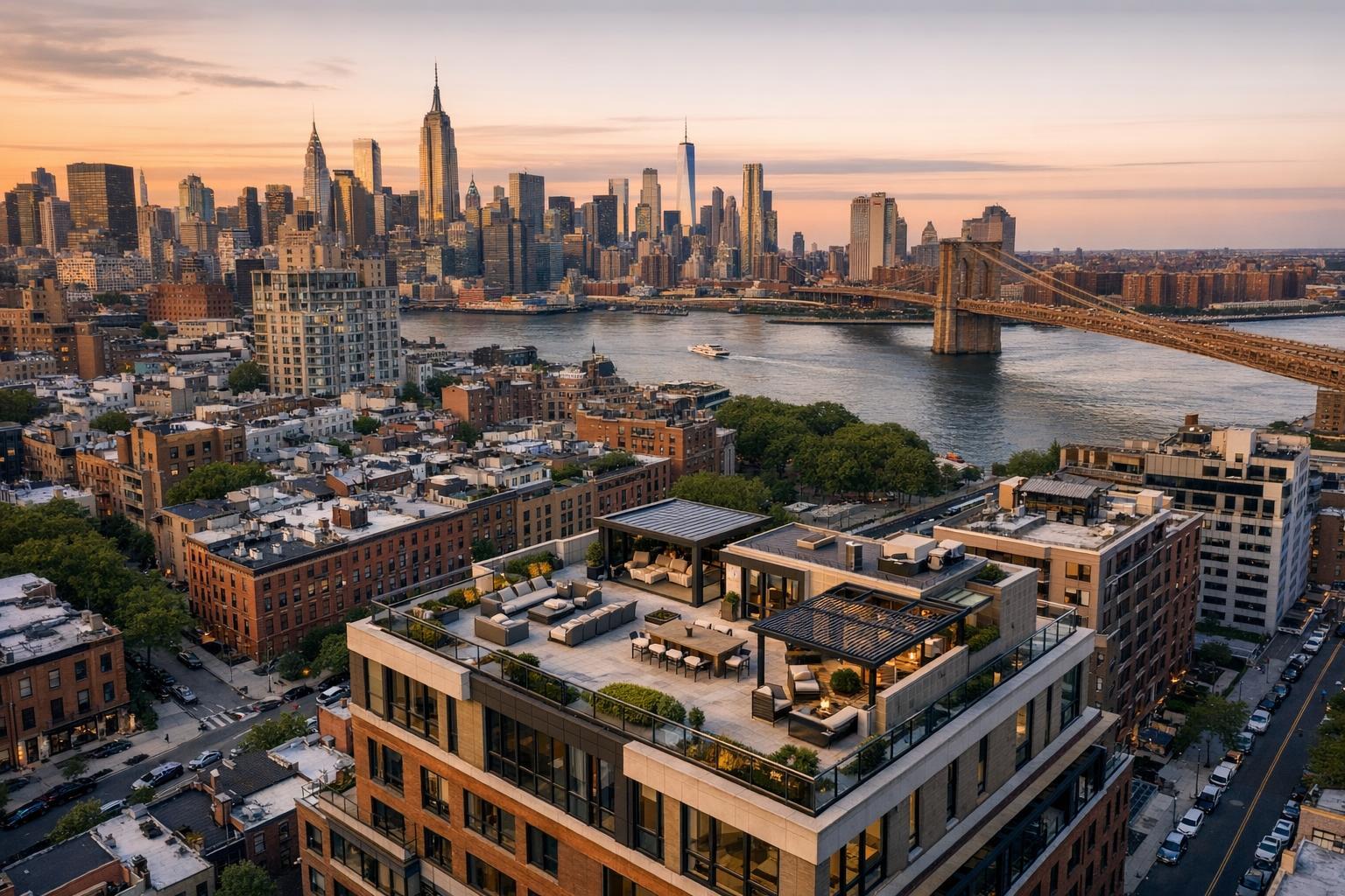
Drone photography captures a stunning real estate rooftop terrace with a panoramic view of the city skyline and a nearby bridge at sunset.
Drone Photography Real Estate: Transforming NYC & NJ Listings with Aerial Perspective
If you’re in New York City or New Jersey real estate, drone photography real estate is quickly shifting from cutting-edge perk to essential listing standard. Today’s most successful agents leverage high-impact aerial real estate photography to capture the unique stories of properties in Brooklyn brownstones, Jersey City high-rises, Hoboken rentals, and suburban estates alike. In this article, you’ll learn the nuts and bolts of why drone photography in NYC and neighboring markets creates a distinct competitive edge—and how RealtaSnap’s reliable, FAA-certified drone services help agents, owners, and hosts win more attention in a crowded marketplace.
The Real-World Problem: Standing Out (and Selling) in a Visual-First Era
Every day, new listings go live on StreetEasy, Zillow, MLS, and Airbnb. In NYC and New Jersey, where inventory is tight and buyer attention even tighter, your first few photos decide whether a listing gets noticed—or passed over. Standard ground-level shots simply can’t tell the full story. Many agents still upload cell phone photos or use rushed media: dark corners, crooked lines, poorly lit facades, missing context, or window glare all make a listing feel uninspiring. For luxury co-ops, investment condos, and architecturally distinct homes, this underwhelming media fails to reflect the property’s real value.
On the commercial side, empty office parks or retail units with bland imagery struggle to attract serious leads. Aerial real estate photography, meanwhile, is often the difference between a property being seen as “just another address” versus “an opportunity with location, scale, and context.”
Without compelling drone visuals:
- Click-through rates are lower, with buyers often skipping listings before reading the description.
- First impressions are weak, especially when property features (like roof decks, parking access, or the building’s position in the block) aren’t clear.
- Sellers and landlords may question an agent’s marketing investment or skill.
- Media inconsistency can make branding efforts feel scattered—especially for teams managing multiple listings.
We’ve seen countless cases where a property’s best features—water views, private gardens, skyline proximity—were invisible in the initial gallery. In these markets, that’s a costly miss.
What Experienced Media Teams Know
Seasoned real estate media professionals understand the technical, aesthetic, and logistical demands behind quality drone photography in NYC and NJ. From shooting full exteriors at the right time of day (think: early morning for east-facing homes, golden hour for penthouses) to monitoring weather windows and airspace restrictions near airports, every flight is a balancing act of planning and creativity.
True professionals obsess over details like:
- Framing a building’s vertical lines properly while flying above sloped Brooklyn streets so it doesn’t appear distorted online.
- Balancing sunlight with shadow so rooftop decks look inviting but not washed out.
- Timing shots to minimize traffic, trash, or unflattering street activity commonly found on city blocks.
- Coordinating with property managers for access and ensuring drone pilots are legally cleared to fly over private spaces, rooftops, or even inside atriums for grand, cinematic reveals.
- Editing aerial shots so clouds, construction cranes, or neighboring eyesores don’t distract from the subject.
- Maintaining a fast, reliable workflow: clients expect images turned around fast—ideally within 24 hours of the shoot—ready to upload and tag for listing sites.
Aerial real estate photography isn’t just about high vantage points. It’s about using perspective, clarity, and light to tell a real story about the property’s context, amenities, and scale.
How RealtaSnap Solves It
At RealtaSnap, our team brings years of hands-on production know-how to real estate media in NYC, New Jersey, and beyond. We’ve built a service that’s engineered for agents who care about consistency, reliability, and results:
- FAA-certified drone pilots: Every flight is legal, safe, and insured—no guesswork, no risky shortcuts.
- Precision planning: We map each shoot according to flight regulations, HOA rules, sun angle, neighborhood quirks, and property highlights.
- Rapid turnaround: Standard photo delivery is 24 hours, even for aerial packages, so your listing goes live fast and looking its best.
- RealtaSnap app experience: Schedule, track, and download your media with zero guesswork. Our in-app chat keeps you informed from booking to delivery.
- Consistent editing: Every shot is carefully corrected for vertical lines, window glare, and skyline smog—a must for city listings.
- Proven workflow: We coordinate with supers, property managers, and doormen for seamless entry and smooth production, even on tight urban lots.
- Clear, fair pricing: Packages start at $199 for drone photography. Commercial-focussed packages with both drone and ground-level assets are available for multi-unit marketing, new developments, and unique venues.
All prices and information are subject to change. Information is deemed reliable but not guaranteed.
Every image is more than documentation—it’s a trigger for buyer imagination, helping viewers see not just the listing, but the future lifestyle or investment it represents. See our complete drone packages at www.realtasnap.com/drone-photography-videography-nyc.
Benefits of Using RealtaSnap Drone Services
- FAA-certified drone pilots for safety and compliance
- 24-hour digital delivery standard for fast listing launch
- Seamless in-app booking, tracking, and media management
- Expert editing for verticality, window exposure, and sky color
- Packages tailored to both residential and commercial needs
- Legal flight planning and insurance included for all NYC/NJ jobs
- Consistent branding across multi-listing marketing
- City-savvy crew fluent in navigating unique urban constraints
- Aerial, interior, and ground-level shots integrated for a cohesive story
- Real-world scheduling flexibility — we adapt to tight windows and busy tenant schedules
Why This Matters in the NYC / NJ Market
New York City and New Jersey real estate are defined by competition and nuance. Urban buyers crave context: Where is that one bed in relation to the park, train line, water? What’s the commute like in Jersey City? How close is the roof deck to iconic landmarks? In Manhattan, outdoor space is at a premium—drone imagery makes even modest patios feel aspirational. Suburban NJ buyers respond to drone shots that highlight open yards, neighborhood amenities, and school proximity.
Rental listings move fast, sometimes in days. Aerial real estate photography speeds up engagement on platforms where a striking first impression can mean multiple inquiries within hours. Commercial buyers, on the other hand, focus on lot lines, access points, and visibility—details only captured from the air.
Different listing sites also prioritize bold visuals at the top of the gallery. In our experience, a stunning drone opener increases listing time-on-page and supports stronger brand recall for agents who consistently use this level of media.
Comparison with Traditional or Lower-Quality Alternatives
We’ve walked into listings where prior agents used cell phones or DIY drone footage—sometimes from unlicensed pilots. The results are telling:
- Phone photos: Warped exteriors, overexposed windows, and cramped rooms undermine trust.
- Rush jobs: Inconsistent angles and poor timing fail to capture the city’s character or property strengths, especially with variable lighting.
- Generic editing: Automated filters obscure fine details, distort colors, or give a “fake” look that turns off discerning buyers.
- Delayed delivery: Missed listing timelines mean lost momentum; the market doesn’t wait.
- Poor staging or prep: Forgotten trash cans, dirty windows, and awkward angles hurt otherwise valuable listings.
- Unlicensed drone ops: Legal risk and possible fines in NYC/NJ airspace.
By contrast, RealtaSnap pairs genuine neighborhood insights with field-tested workflow—whether handling a Hoboken brownstone on a rainy Tuesday or a West Village penthouse at sunset. Real professionalism shows up in “invisible” ways: polished results every time, peace of mind for the listing agent, and media that works across every platform and social channel.
Real-World Use Cases: Where Drone Photography Shines
- Tribeca lofts and SoHo walk-ups: Towering drone shots show block character, park access, and unique rooflines.
- Jersey City and Hoboken condos: Aerials reveal transit convenience and skyline proximity.
- Brooklyn brownstones: Angled shots emphasize garden spaces and tree-lined streets.
- Commercial Manhattan towers: Bird’s-eye perspectives display property scale and signage opportunities.
- Suburban Essex or Bergen homes: Sweeping yard and pool views help families envision outdoor living.
Conclusion & Call to Action
Today’s buyers expect immersive, visually rich listings—especially in NYC and NJ, where properties must shine instantly to stand out. With RealtaSnap’s proven approach to aerial real estate photography, you’ll capture attention and elevate your brand with every listing. Ready to invest in smarter, more effective property marketing? Learn more and book your next drone shoot at realtasnap.com/drone-photography-videography-nyc. Every property has a story. Let’s tell it—brilliantly, and from above.
Frequently Asked Questions
1. Is drone photography legal in NYC and New Jersey?
Many agents are concerned about the risks of illegal flights or fines. At RealtaSnap, every drone flight is handled by FAA-certified pilots and always complies with local airspace regulations. This ensures your listing is promoted safely and legally, with proper insurance and permits in place.
2. How fast can I get my drone photos after a shoot?
Time-to-market is a real concern, especially for fast-moving rentals and sales. RealtaSnap delivers edited drone images within 24 hours post-shoot, so your listings can go live quickly and confidently—all through a seamless digital portal, with no back-and-forth or uncertainty.
3. What if I need both drone and ground-level photos?
Some providers only do one or the other, which means piecemeal service and inconsistent results. RealtaSnap offers complete media packages—combining aerials, interiors, exteriors, and more—so you get cohesive, consistent, ready-to-upload assets, all organized in your app account for instant use.
Discover more about our drone and real estate media services at www.realtasnap.com.
All prices and information are subject to change. Information is deemed reliable but not guaranteed.


