Assessing the Impact of Drone Photography on NYC Real Estate Marketing
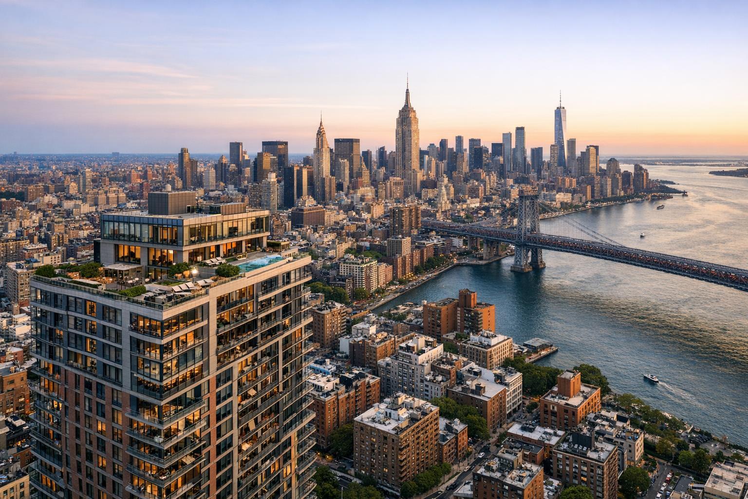
Drone photography captures the stunning skyline of New York City with the Empire State Building and a bridge spanning the river at sunset.
Drone Photography NYC: Elevating Real Estate Media with Aerial Perspectives
As drone photography NYC becomes a standard in real estate marketing, agents and property managers across New York, New Jersey, and nearby markets are discovering how aerial photography and carefully crafted real estate media can transform listings that might otherwise be overlooked. In this article, we’ll break down the practical impact of drone imagery, explore how a seasoned media team approaches every listing, and share actionable best practices for agents who want lasting results with drone technology. You’ll learn how drone photos genuinely make listings stand out, why visual quality matters so much in NYC and NJ, and what makes RealtaSnap's approach both effective and reliable for property professionals.
The Real-World Problem: Why Traditional Property Photos Struggle in NYC and NJ
Let’s get real about the challenges. Even in high-demand neighborhoods, NYC and New Jersey agents know what happens when a listing’s visuals fall short. You upload your new listing, but the photos look flat, its outdoor areas appear cramped, and none of the angles show the buzz of the block or the skyline view that buyers crave. Walk-up buildings blend into the background; rooftop decks look small or inaccessible; backyards are hidden by shadows or neighboring fences.
Weak real estate media causes several tangible problems:
- Low click-through rates: Listings with predictable or uninspiring 2D photos slide past in search results.
- Forgettable first impressions: When buyers browse on mobile or scroll quickly, average visuals rarely stop thumbs.
- Empty or awkwardly lit spaces: Interiors that look dim, harshly shadowed, or cluttered cost you valuable buyer interest.
- Limited imagination: Prospective buyers can’t visualize outdoor potential or neighborhood context from ground-level images alone, and small NYC lots are easily misunderstood.
- Slower deal timelines: Stale-looking listings remain on the market longer, affecting perception, price, and client satisfaction.
- Branding inconsistency: Without a professional approach, even a high-end property can look generic or bland.
We see it firsthand: When photos feel like afterthoughts or are “quick fixes” from a phone, even great inventory can stall. This is especially true in markets as competitive, visually driven, and densely packed as NYC and New Jersey.
What Experienced Media Teams Know: Hard-Learned Lessons from Actual Productions
In our experience capturing thousands of properties in NYC, Jersey City, Hoboken, and the surrounding area, true impact starts long before the shutter clicks. Professional real estate photographers and drone pilots think beyond the obvious angles.
- Timing is everything. We track light throughout the day—shooting exteriors when the sun is at an angle that flatters architectural lines and avoids harsh midday glare off glass and brick. For interiors, we often time shoots so the sun streams in through main windows, then bracket exposures for balanced results that avoid blown-out skies.
- Room prep shapes every shot. We collaborate with agents to declutter, stage appropriately, and even shift small décor for maximum visual flow. For drone work, we ensure outdoor spaces are clear—lawn furniture straightened, decks swept, and any signage or features aligned.
- Framing isn’t just point-and-shoot. Every photo is composed to show space, not just square footage. We correct verticals so buildings don’t look like they’re tilting, and for drone shots, we compose at heights that show off terraces, bay windows, and proximity to amenity spaces or city icons.
- Editing and delivery must be as consistent as the shoot. Our workflow blends multiple exposures for every room and embraces both color accuracy and a touch of warmth—buyers want clarity, but they also want allure. Post-production is as important as capturing the moment.
- Aerial storytelling adds dimension not possible with ground photography. A drone’s perspective reveals the “feel” of a block, the privacy of a backyard oasis in Brooklyn, or the walking proximity to transit in Weehawken or Edgewater.
Clients repeatedly tell us how aerial photography helps buyers “get” a space before ever booking a tour. These aren’t just pretty pictures—they’re real tools for faster, higher-confidence sales and leases in a platform-driven era.
How RealtaSnap Solves It: Practical, Reliable, and Grounded in Results
At RealtaSnap, we don’t just fly a drone and hand off the images. We approach every listing as an opportunity to showcase a property’s unique story—and our process reflects that commitment:
- Tailored Aerial and Ground Coverage: Our experienced team evaluates each property, recommending drone photography, ground-level stills, and even cinematic video to tell a complete story. Whether you’re listing a Tribeca penthouse or a Jersey City brownstone, we create images that highlight strengths and minimize distractions.
- Licensed, Insured, and FAA-Certified Pilots: You never risk safety, regulatory compliance, or building management headaches. All drone operations are handled by professionals familiar with NYC and NJ’s specific flight restrictions and airspace rules.
- Reliable Turnaround Times: We know how critical listing launch dates are. RealtaSnap delivers edited, ready-to-upload media within 1–2 business days after the shoot, with clear communication every step of the way.
- Consistent Editing and Branding: Our dedicated in-house editing team corrects for color, line alignment, and window exposures so listings always present cohesive, magazine-quality visuals—no matter the weather on shoot day.
- On-Site Guidance: Our team helps with staging tweaks, directs simple rearrangements, and actively collaborates with agents and homeowners for best results. We’re not just photographers; we’re partners in the branding process.
Want to see how this works for your next listing? Explore RealtaSnap’s drone photography services for NYC, New Jersey, and beyond.
Benefits of Choosing RealtaSnap
- Consistent, high-impact photography for every listing
- Licensed, compliant, and insured drone operations
- Fast turnaround: typically 1–2 business days
- Professional onsite staging and visual advice
- In-depth understanding of NYC/NJ neighborhood dynamics
- Post-production for magazine-quality results
- Seamless booking and transparent communication
- Visuals tailored for top NYC listing platforms
- Aerial photography that highlights real selling points
- Adaptable for condos, brownstones, new construction, and rentals
Why This Matters in the NYC / NJ Market
Urban and suburban property markets around New York City and New Jersey are among the most competitive in the country. Buyers—local and international alike—often search online first, relying heavily on visual media to decide what to tour in person. In NYC, roof decks and skyline views are prized yet easy to miss with phone photography. In Jersey City or The Heights, unique exterior angles or proximity to the PATH create premium value but are hard to communicate without aerial imagery.
NYC’s dense built environment means that even high-end interiors feel compressed without skillful camera work—especially for units with limited natural light or constrained outdoor space. Aerial photography does more than look dynamic: It provides proof of lifestyle, context, and potential that’s essential when buyers are comparing five listings in 30 minutes.
Rental competition is fierce: Clear, compelling real estate media helps you set your property apart quickly, attract motivated tenants, and reduce days-on-market in both busy and slow seasons.
Comparison with Traditional or Lower-Quality Alternatives
Let’s be honest about what many listings still look like:
- Phone Photos: Even the latest smartphones struggle with verticals, dynamic range, and window exposures, often leaving rooms either washed out or underexposed. Exteriors shot from the street can make premium amenity spaces appear small or ordinary.
- Rushed “Point-and-Click” Services: Speed over quality means you miss the subtle staging, angle adjustments, or careful lighting that professional photographers provide—and it shows. Platforms like StreetEasy and Zillow are flooded with cookie-cutter images that do nothing to differentiate listings.
- Inconsistent Editing: Without careful post-processing, colors are inaccurate, and photos can look cold or artificially sharpened. This inconsistency hurts agent branding and confuses buyers.
- Delays and Lack of Communication: Fast-moving markets mean agents can’t afford to wait days for their photos, wonder when they’ll arrive, or struggle to contact an overbooked provider.
RealtaSnap is designed for agents who want a reliable, results-driven partner—not just a vendor. Our blend of field-tested technique, local insight, and streamlined workflow ensures your listings consistently look their best.
Conclusion & Call to Action
In the fast-paced world of New York City and New Jersey real estate, every listing only gets one chance to make a great first impression. Thoughtfully executed drone photography and professional real estate media aren’t luxuries—they’re competitive necessities for agents, hosts, and property managers looking to stand out.
If you’re ready to enhance your listings, attract more qualified buyers or tenants, and build a brand that buyers recognize, discover RealtaSnap’s full suite of services today. Our experienced team is ready to help your next listing shine. All prices and information are subject to change. Information is deemed reliable but not guaranteed.
Frequently Asked Questions
1. How much does drone photography in NYC and New Jersey cost, and is it worth the investment?
Pricing depends on property size, location, and the media package selected. At RealtaSnap, aerial photography starts at $299 for standard residential drone shoots. Many agents find that high-quality drone images increase click-through rates, support stronger offers, and justify their costs in days-on-market savings and client satisfaction. All prices and information are subject to change. Information is deemed reliable but not guaranteed.
2. Are there legal restrictions or special preparations for drone imagery in urban markets like NYC?
Yes, New York City and New Jersey both have unique airspace, building, and privacy regulations. At RealtaSnap, all drone flights are operated by FAA-certified, insured pilots who handle necessary permissions and safety checks. We also coordinate with building management and work with agents in advance to prepare outdoor areas and maximize shoot efficiency, so you don’t have to worry about compliance details.
3. What if my property doesn’t seem “drone worthy”—will aerial photos still add value?
Absolutely. Whether it’s a garden-level co-op in Brooklyn, a rooftop condo in Jersey City, or a suburban home in Short Hills, aerial photography can reveal features, exterior layouts, and neighborhood amenities that are hard to capture otherwise. Our team tailors each shoot to fit the property’s unique strengths, ensuring you get imagery that works—for every listing, not just the obvious standouts.
If you have more questions or are ready to upgrade your visual marketing, RealtaSnap’s NYC drone photography team is here to help.


