Analyzing the Role of Drone Photography in Shaping Modern NYC Real Estate Listings
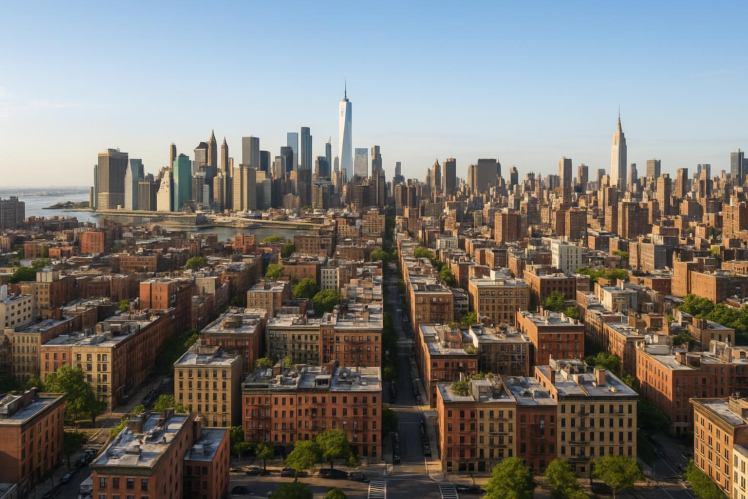
Drone photography captures the expansive view of New York City's skyline with prominent skyscrapers, streets, and the waterfront.
Drone Photography NYC: How Aerial Imagery Is Transforming Real Estate Marketing in New York and New Jersey
If you’ve been searching for ways to stand out in the crowded world of real estate listings, you’ve likely come across the increasing power of drone photography NYC specialists bring to the market. In fact, drone-based aerial real estate photography isn’t just a trend—it’s rapidly becoming a must-have for agents, property managers, brokers, and sellers across Manhattan, Brooklyn, Queens, New Jersey, and beyond. In this article, you’ll learn how drone photography is reshaping property marketing, the real-world challenges it addresses, and what sets expert providers like RealtaSnap apart for local listings.
The Real-World Problem: Why Standard Listing Media Falls Short
Every seasoned agent, rental host, or property owner in NYC and New Jersey knows the pain points when launching a new listing:
- Low click-through rates on Zillow, StreetEasy, or Realtor.com—photos just blend in.
- Listings generate weak first impressions, especially for unique or high-value buildings where the context, landscaping, or skyline is never shown.
- Inconsistent lighting and narrow angles limit what buyers or tenants see; rooms look smaller and less inviting.
- Empty outdoor areas and rooftops get overlooked, leading to wasted amenities.
- Slow buyer engagement stalls showings. Days go by before the right person reaches out.
- Media that misrepresents scale—small apartments appear tight and cramped, while expansive listings lose their grandeur.
- Urban context or neighborhood is entirely missing from the visuals.
- Branding is inconsistent when phone snaps or piecemeal media are used.
For commercial listings, the problem is even more pronounced: potential tenants want to see access, traffic, visibility, and proximity to landmarks—none of which a ground-level shot can fully convey.
RealtaSnap’s team hears this over and over: “We have a beautiful building, but the photos don’t do it justice. Buyers or renters just aren’t feeling the impact online.”
What Experienced Media Teams Know (Real-World Workflow Insights)
As real estate media professionals serving NYC, NJ, and surrounding markets, our team at RealtaSnap has spent thousands of hours on site, climbing rooftops, troubleshooting airspace restrictions, balancing difficult exposures at golden hour, and solving problems agents didn’t even know they had. Here’s what we know because we’ve lived it:
- The best aerial real estate photography happens with thoughtful timing. Lighting changes rapidly across Manhattan, so capturing at midday can wash out terraces, while shooting at golden hour creates depth and shadowplay—even if you only have a short window.
- Room and terrace preparation matters. Uncluttered rooftops, staged patios, and clean decks ensure drone images look intentional, not accidental.
- FAA compliance isn’t just a box to check. In NYC especially, drone photography requires active evaluation of airspace, proper pilot licensing (FAA Part 107), and strict on-site safety assessment. It’s not worth risking fines or flight bans for one dramatic image.
- Consistent window exposure and vertical line correction in editing are crucial for presenting even city landmarks realistically; distortion can quickly mislead buyers or make the space look “off.”
- Rapid, reliable turnaround matters. In a hot market, media teams need to deliver next-day or 48-hour assets, so listings go live when interest is highest—not a week after the shoot.
- Editing restraint is key. Real buyers notice when blue skies are replaced, but even subtle object removal or light retouching can dramatically increase visual appeal if done tastefully.
We’ve also seen listings get passed over simply because the aerials were missing, looked generic, or showed too many parked cars and neighboring roofs. True mastery is knowing which angles capture the most value—and which angles to skip.
How RealtaSnap Solves It
RealtaSnap’s drone photography real estate services are built for agents, owners, and marketing pros who want stunning, trustworthy imagery, delivered with speed and professionalism. Here’s how we address the challenges, from scheduling to delivery:
- Local Market Knowledge: We operate across New York City (all boroughs), New Jersey, and select surrounding markets—meaning we know the building types, airspace challenges, and legal landscape specific to your listing【20:10†RealtaSnap_Service_Areas_MASTER.docx】.
- FAA-Compliant Operations: All RealtaSnap drone shoots are conducted by licensed pilots (FAA Part 107) who evaluate airspace conditions, required clearances, and on-site logistics before every flight. We handle standard drone authorizations and advise if special permitting is needed.
- Flexible Options: Choose from aerial photos, video, or both—including blue sky replacement, high dynamic range (HDR) capture, and seamless integration with your main listing photos. See our full service options at RealtaSnap Drone Photography NYC.
- Operational Expertise: Our workflow ensures room and exterior prep guidance is provided upfront, and we optimize shots for both residential and commercial properties, from high-rise condos to boutique retail spaces.
- Fast Turnaround: Typical delivery is within 24–48 hours—a crucial asset in fast-paced markets.
- Transparent Pricing: Drone photo packages begin at $209 for 10 HDR images, with video and combo options available. All prices and information are subject to change. Information is deemed reliable but not guaranteed【20:5†RealtaSnap_Rate_Sheet_MASTER.docx】.
- No Surprises: Our media team captures what actually exists—no speculative changes or over-promising. High-quality edits and virtual enhancements are available per project needs (see rate sheet for optional add-ons).
You can book your session in minutes, using our online scheduler or mobile app, and receive all your media ready to download and use for MLS, social, or your website【20:1†RealtaSnap_Booking_Process_MASTER.docx】.
Benefits of Choosing RealtaSnap Drone Photography
- FAA-certified pilots for safe, legal aerial captures
- 24–48 hour delivery standard for most media packages
- Local market expertise across NYC and NJ
- Photo, video, twilight, and add-on options
- True HDR and blue sky replacement for maximum impact
- Seamless media integration with ground-level photography
- Realistic edits that preserve architectural accuracy
- Transparent, competitive pricing
- Clear communication and trusted on-site process
- Easy online booking and project management
Why This Matters in the NYC / NJ Market
Real estate in NYC and New Jersey is unlike anywhere else. High-rise condos, co-ops, brownstones, mixed-use buildings, and commercial storefronts all demand different visual strategies. Here’s why drone photography real estate solutions matter so much here:
- Buyers expect context. They want to see proximity to parks, subways, rivers, and unique features like rooftop amenities, outdoor terraces, and neighborhood landmarks.
- Rental competition is fierce. Landlords and property managers need aerial real estate photography to show off shared spaces, outdoor seating, and walkability—especially in crowded boroughs.
- Commercial buyers and tenants look for visibility—not just square footage, but signage exposure, corner lot status, and surrounding traffic.
- Listing platforms favor strong visuals. Image-heavy interfaces on sites like Zillow, Streeteasy, or CoStar reward listings with compelling hero images and aerials, driving more eyes to your page.
In a market where “average” is overlooked, the right media strategy can be the difference between days on market and a property that lingers.
Comparison with Traditional or Lower-Quality Alternatives
While it may be tempting to cut corners with smartphone snaps, stock aerials, or DIY drone work, here’s what property professionals actually encounter:
- Phone photos produce distorted perspectives, fail to convey scale, and lack the resolution for print or large digital display.
- Rushed media shoots almost always miss the best light or the optimal window for aerials, especially in urban environments where shadows and building reflections shift by the hour.
- Inconsistent editing leads to color imbalances, crooked skyline lines, and missed branding opportunities.
- Delayed media delivery hurts listing performance—by the time your visuals arrive, buyer interest may have already shifted elsewhere.
- Generic providers may not know the unique regulatory environment of NYC/NJ airspace—putting your listing or reputation at risk with flights that are delayed, canceled, or outright illegal.
RealtaSnap is purpose-built to avoid these traps. Our team’s field experience means we anticipate and navigate urban complexities, delivering consistently impactful imagery every time. Visit www.realtasnap.com to view our latest drone real estate projects across the five boroughs and New Jersey.
Conclusion and Call to Action
In New York and New Jersey’s hyper-competitive markets, it’s not enough to just “show” a property—you need to captivate, inform, and inspire. Drone photography NYC solutions from RealtaSnap combine cutting-edge aerial technology, expert local production, and real-world reliability to help your listings stand out. Whether you’re an agent, property manager, or owner, our team brings deep operational know-how and transparent pricing to every shoot.
Ready to elevate your next listing with professional aerial real estate photography? Learn more or book now at RealtaSnap Drone Photography NYC or visit www.realtasnap.com.
Frequently Asked Questions
1. Is drone photography always available for every NYC or NJ listing?
Not every property is eligible for drone photography, especially in areas with restricted or controlled airspace. Our FAA-certified pilots assess airspace, safety, and building access before the shoot. We’ll let you know upfront if your site poses unique challenges, and we only accept projects we can complete both legally and safely. If a flight isn’t feasible, we’ll recommend alternative ways to enhance your listing.
2. How do I prepare my property for an aerial shoot with RealtaSnap?
Clear outdoor spaces, remove clutter from rooftops or patios, and ensure any outdoor amenities are set up to look inviting. Our team provides guidance on prepping for drone sessions, and we always coordinate with you to optimize each shot. Proper prep helps us achieve the best possible visuals of your space.
3. What is included in RealtaSnap's drone photography packages, and how fast will I get my images?
Choose from photos, video, or both, all captured and edited by our experienced media team. Standard delivery is typically within 24–48 hours after the shoot. Packages include HDR capture, blue sky edits as needed, and seamless handoff so you can start marketing right away—all at transparent published rates. We’re committed to delivering efficiency and peace of mind every step of the way.
All prices and information are subject to change. Information is deemed reliable but not guaranteed.


